Lake Butrint and Vivari Channel EarthCache
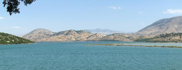
Lake Butrint and Vivari Channel
-
Difficulty:
-

-
Terrain:
-
Size:  (not chosen)
Please note Use of geocaching.com services is subject to the terms and conditions
in our disclaimer.
Introduction
During our 10-days holiday on Corfu in August 2008 we visited
Albanian Saranda and historical place Butrint. The road joining
these two places, which is incredibly narrow, takes round Lake
Butrint. Because no cache is placed in this spectacular area we
decided to create Earthcache there.
If you interested in spectacular places we can recommend you our
three Earthcaches that we decided to create on Corfu:
Pantokrator,
Pantokrator II and
Bella Vista to Paleokastritsa.
Enjoy this spectacular countryside!
Hydrology
Lake Butrint is placed in a seaside wetland complex in the
south-western part of Albania, famous for its archaeological
monuments (ancient port of Buthrotum), historical significance, and
natural richness. The core area is composed by a tectonic lagoon of
1600 ha that is surrounded by forested hills and mountains and
complemented by saltwater and freshwater marshlands. The maximum
depth of Lake Butrint is 21 metres. From a geomorphology point of
view Lake Butrint is contained to the Ionian zone.
The catchment of Lake Butrint is defined by Bistrica River in the
North, Mile Mountain in the west and the Pavllo River in the south.
The lake has a tectonic origin while its water regime is typical of
coastal lagoons. It joins the Ionian Sea through the channel of
Vivari (3600 m long, 60-100 m wide and up to 5-6 m deep). During
high tides (approx. 15-20 cm), the sea level rises and as a
consequence the saline water penetrates into Lake Butrint. The
opposite phenomenon happens during low tide. A small amount of
continental water, deriving from Bistrica and Kalasa rivers, enters
the lagoon in its northern side.
Lake Butrint has mesotrophic waters with eutrophic tendencies in
certain risky areas. The limnology of the lake is divided into two
distinct layers. The upper layer (approx. 8 m in depth) is rich in
oxygen. Its concentration is about 8-9 mg/lit on the surface and
reduces to zero by the depth of 7.5-8m. Salinity fluctuates with
seasons: from 15.00 gr./l in winter till 33.00 gr./l in summer. The
values of pH oscillate Information Sheet on Ramsar Wetlands (Ris):
Butrint (Albania) 4 between 6.5 and 9.5. The organic matter is
about 2–10 mg/l. Water temperature fluctuates from 14°C in winter
till 25°C in summer. The lower layer is rich on sulfuric gas. Its
concentration increases with depth and reaches the highest level at
the bottom of the lake (>5.0 mg/lit). Salinity remains nearly
the same throughout the year (35.00 gr./l). Temperature has a
relative homothermy of 18°C throughout the whole year. No animals
are found in the lower layer. Lake Butrint is surrounded by
different ranges of mountains and hills: Mile mountain range to the
east (845 m), Sotira to the west (240 m) and Stillo to the south
(240 m). This higher terrain compliments the lower wetland areas by
providing environmental corridors and areas where there is less
human disturbance for wildlife. The coastline is much refracted,
with many peninsulas, islands and small deep bays. From a
morphological point of view it is divided into two main types: high
abrasive coast and low accumulating coast. Butrint is characterised
by mild Mediterranean climate. The annual average temperature is
17.1°C. Temperatures fluctuate from 9.7°C in January to 25.1°C in
August. Rain precipitation is relatively high, over 1,500 mm per
year.
Lake Butrint and Vivari Channel
Additional historical information
Very close to Lake Butrint there is placed a historical area
Butrint. Butrint occupies the small Ksamili peninsula between the
Straits of Corfu and Lake Butrint. Due to such a strategic position
on the Mediterranean Sea, there were many military operations for
the control of the area from the first Peloponnese war (V Century
B.C.) until the Napoleonic wars (XIX Century).
Butrint was controlled by the Tribe which was part of the Greek
Epirot Federation. Colonists from Corcyra settled in Butrint around
the IV Century B.C. within a century of the Greeks arriving.
Butrint had become one of the ancient world’s major fortified
maritime trade centres with its own acropolis.
Butrint then came under the control of the Illyrians anxious to
control the maritime trade and during the third Macedonian War in
167 B.C. the city was conquered by the Romans. The Romans used the
port as a supply base for military campaigns in Epirus and
Macedonia in the II Century B.C. and area was afterwards
‘romanised’. With the creation of the Byzantine Empire in the East,
Butrint was therein enveloped and remained part of the Empire until
the latter’s fall at the hands of the Turks in 1453. Barbarians,
Vandals, Slavs, Goths invaded the city, the Slavs settling there
from the VII Century until the Byzantines expelled them in the IX
century. With the defeat of the Venetians by Napoleon’s army in
1797, this coveted city briefly became part of the French Empire
until 1798 when fortune changed again and it was seized from the
French by the Albanian lord Ali Pasha of Tepelene. Butrint remained
part of the Ottoman Empire until 1912, when Albania became an
independent state.
From the XII Century however, Butrint was in decline. A
catastrophic earthquake in 1153, the conquest by the Venetians, the
subterranean infiltration of water and the subsequent epidemics
completed the ruin of the city and forced the inhabitants to flee.
Throughout the occupation by the Ottoman Empire, from the 15th to
the 20th centuries, the city remained in deep slumber. The waters
covered Butrint in mud, and abundant vegetation completely hid the
city from view until the 1920s when Mussolini, tracing Aeneas’
footsteps, ordered the first excavation of the area. Butrint was
designated a UNESCO world heritage site in 1992.
For more details please click here:
http://www.butrinti.com or
http://www.butrint.com.
Butrint - Historical site
How to get the earthcache coordinates
The Earthcache “Lake Butrint and Vivari Channel” is reachable using
car or bus and road from Saranda. Drive carefully because the road
is very narrow! You can park very close to earthcache coordinates.
The Earthcache is also reachable using boat. The Earthcache
coordinates brings you close to the Vivari Channel.
The Earthcache “Lake Butrint and Vivari Channel” coordinates also
brings you close to the main entrance to the Butrint historical
area. If you want to enter you will have to pay some money.
Although to approve finding of this Earthcache you do not have to
enter Butrint historical area we highly recommend visiting this
magnificent spot.
How to get the reference point coordinates
The reference point of the Earthcache “Lake Butrint and Vivari
Channel” is reachable using car or bus and the same road from
Saranda to Butrint. Drive carefully because the road is very
narrow! The Reference Point of the Earthcache is probably also
reachable using boat and your foot. The Earthcache coordinates
brings you close to Lake Butrint.
Approving the finding
To approve the finding of this Earthcache you need to:
1) Using profile e-mail me which lithologic basis is under Lake
Butrint and Vivari Channel. Please select one of the following
possibilities: slate, conglomerate, magmatic rock, dolomite,
limestone or soil.
2) Using profile e-mail me if the Vivari Channel originated
naturally or if it was created by humans.
3) Using profile e-mail me which type of the water (salt or fresh)
in Lake Butrint and Vivari Channel.
4) Using profile e-mail me what is the altitude above the sea level
of Lake Butrint and Vivari Channel.
5) Upload in the log photo from the “Lake Butrint and Vivari
Channel” earthcache coordinates N 39° 44.634 E 020° 01.143 with you
and the Vivari Channel behind you (see spoiler) or with you in from
of the entrance gate. Any other photos from the historical area
with you are welcomed.
6) Upload in the log photo from the reference point coordinates N
39° 47.470 E 020° 00.530 (or its near surroundings) with you and
Lake Butrint behind you. If you travel by bus you can take a photo
inside the bus with Lake Butrint and a bus window behind you.
Please feel free to log your finding and to send your answers for
approving questions at the same time. If your answer will be
incorrect we will contact you for its correction.
Additional Hints
(Decrypt)
1) hfr vagrearg
2) hfr vagrearg
3) gnfgr vg be hfr lbhe oenva
4) ybbx ebhaq ubj gur punaary naq ynxr ybbx yvxr naq hfr lbhe oenva
5) gnxr n cubgb ng gur rnegupnpur pbbeqvangrf (frr fcbvyre)
6) gnxr n cubgb ng gur ersrerapr cbvag pbbeqvangrf