Silver Sands State Park, Milford, CT1.
Is
this a Tombolo?

Aerial photograph of Charles Island
with it’s “tombolo”, taken in 2004.
A tombolo is a depositional land-form that
creates a narrow neck of land connecting an offshore rock or island
with the mainland. Sand is deposited in such a fashion
because waves refract (bend) around both sides of the island and
thus wash sand toward the middle, where it is deposited.
Charles Island at Silver Sands State Park is connected to the
mainland beach by a gravel bar. Although it is referred to as
a tombolo, it appears more that it is left behind from erosion
rather than deposited. We will explore that notion in this
EarthCache.
The “tombolo” is submerged most of the time
and Charles Island is only accessible at low tide. The
“tombolo” is flooded by as much as 4 feet of water during high
tide. People venturing out onto the island should be acutely
aware of the tides. The “tombolo” is only above water for
about two hours per tidal cycle. Currents over the flooded
neck can be tricky and an undertow develops during some
conditions. Therefore, to complete this
EarthCache, the smart cacher will look up the tide
charts2 and will plan the trip to start about and hour
or 90 minutes before low tide and head back to the mainland no
later than an hour after low tide. If you are late in
returning you may have to wait 12 hours for the next low tide (it
will be dark and cold) or you may have to swim; the currents are
said to be tricky. You may wish you had a kayak.
Purpose: This EarthCache is
published by the Connecticut Geological and Natural History Survey
of the Department of Environmental Protection. It is one in a
series of EarthCache sites designed to promote an understanding of
the geological and biological wealth of the State of
Connecticut.
Location:
N. 41o 11.9016’, -073o 03.9708’
Directions: Off I-95: take Exit
35. Follow Schoolhouse Road south to Route 1 (Bridgeport Avenue).
Turn left onto Route 1 then right at first light (Silver Sands Park
Way). Follow Park Way across Meadowside Road and continue down hill
to main parking lot. There are no park entrance or
parking fees (as of Summer, 2008).
Silver Sands is Connecticut’s newest shoreline
State Park. It was created by reclaiming an old land-fill and
sewage treatment plant. According to Joseph Leary (2005),
“Extensive clean-up work has turned Silver Sands into one of the
state’s prettiest beaches,” and the area wild-life is coming
back. A broad salt-marsh separates the beach from the
1. A description of the geology of this
state park has been written and is awaiting posting at the State
Parks section of the DEP
website.
2.
http://www.saltwatertides.com/pickpred.html
mainland. The marsh was larger prior to
the land-filling operation. The large mound just to the west
of the road is the covered land-fill. A large box-culvert at
the east end of the beach drains the salt marsh
Some of the beach sand is natural, but its
coarseness suggests that some has been added during the
clean-up. The sand on the beach-face is noticeably coarser
than the sand that is uncovered at low tide. In addition,
beach-sand east of the park contains more shells and slightly finer
grained than sand inside the park. It is also narrower than
the beach in the park.


A.
B.

C.
D.
Figure 1. A. Box culvert draining the
salt-marsh behind the beach. Notice more sand on the park
side (left) of the culvert relative to that of the east. B.
Beach sand east of the park contains more shells and is finer
grained. C. Coarse sand on the park beach.
D. Fine sand on beach to east of box-culvert.
Find N. 41o 11.5195’,
-073o 03.4014’. Charles Island is a little
more than a half-mile off shore from the beach. Access is
over a rocky “tombolo” at low tide. BE AWARE OF THE TIDES
and do not get caught on the island after the tide has begun to
submerge the “tombolo” (reread the warning at the beginning of this
EarthCache). The tombolo is relatively straight and
covered with pebbles, cobbles and boulders. At its landward
end there is a sand and shell veneer. At the island
connection there is a “tail” of shell sand. The rest of the
tombolo is covered by a armor of stones that do not move around
much during the year. These stones are not wave-deposited but
rather are left behind. We refer to them as a
“lag-deposit”.

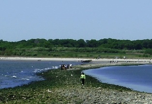
Figure 2. Left: Tail” of shelly
sand deposited on north side of island at its connection to the
“tombolo” Right: Central part of “tombolo” has no sand
deposits; rather it is a lag of cobbles that were too large
to be eroded by storm waves. Note in distance the sand veneer
on the “tombolo” at its attachment to the mainland.
The beaches of Charles Island itself are of
interest. The interior of the island is a nesting area for
egrets and herons. PLEASE DO NOT ENTER THE INTERIOR OF THE
ISLAND AND DISTURB THEM! Indeed, access is restricted
during nesting season (May 12 to September 10) by the Parks
Department. The beaches are littered with a great variety
of large and small stones that were brought and left by the glacier
during the last ice age. Many are a porphyritic
mafic-gneiss, others are porphyritic granitic-gneiss. Some
however, are quartzite, basalt, and biotite schist. That they
all are concentrated here suggests that this


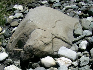
Figure 3. Typical rocks composing the
end moraine of Charles Island. Left: Porphyritic mafic
gneiss. Center: Porphyritic granite gneiss.
Right: Fine-grained basalt.
is an end moraine left by the glacier during
its melt-back history (Stone and others, 2005). The melting
stopped for several years and the glacial front remained in this
position long enough to deposit a moraine.
The source of the rocks in the end moraine is
of interest. The porphyritic mafic- gneiss, which makes up a
considerable proportion of the boulder and cobble population, is
identical to the outcrops along the road entering the park.
It is mapped as a metavolcanic rock by Rodgers (1985). The
porphyritic granite-gneiss is similar in appearance to the Harrison
Gneiss that crops out in the Shelton-Ansonia area, about five miles
north-northwest of the park. The basalt is problematic.
The closest outcrops of basalt/diabase to the north-northwest of
the park are in the Ansonia-Seymour area (the Bridgeport
Dike). It is possible that the source for the basalt is the
Buttress dike, but the closest known outcrops are northeast of the
park. The orientations of streamlined (drumlin-like) hills
and glacial grooves and striations in this area are toward the
southwest (Flint, 1968; Stone and others, 2005), suggesting
that glacial movement could have brought basalt boulders from the
known areas of outcrop. Alternatively, because the trend of
the Buttress Dike is southwestward, possible outcrops of the
Buttress Dike could be just north and northwest of the park and
today are covered by glacial soils.
By definition, a tombolo is a depositional
landform created by wave refraction around the island or rock to
which the tombolo is connected. This is problematic because
the “tombolo” at Charles Island does not appear to be deposited by
wave refraction. Rather it appears that it was deposited as
glacial till and subsequent wave erosion has removed sand and silt
leaving behind a concentration of cobbles and small boulders that
form the land connection. It is noteworthy that Patton and
Kent (1992), in their description of Connecticut shoreline
environments, omit Charles Island in the discussion and
illustration of tombolo landforms.
References.
Flint, R.F., 1968, The surficial geology of
the Ansonia and Milford Quadrnagles, with map
State
Geological and Natural History Survey of Connecticut, Quad. Rpt.
23, 36p
Leary, Joseph, 2004, A Shared
Landscape: A Guide and History of Connecticut’s
State
Parks
and Forests. Friends of Connecticut State Parks, CT
D.E.P, and CT Forest and Park Association, Hartford, CT, 240p.
Patton, Peter and James Kent, 1992, A
Moveable Shore, the Fate of the Connecticut Coast.
Duke
University Press, Durham, N.C., 143p.
Rodgers, John, 1985, Bedrock Geological Map of
Connecticut. State Geological and
Natural
History Survey of Connecticut, Nat’l. Resource Atlas Series,
1:125,000, 2 sheets.
Stone, J.R., Schafer, J.P., London, E.H.,
DiGiacomo-Cohen, M.L., Lewis, R.S., and
Thompson,
W.B., 2005, Quaternary Geologic Map of Connecticut and Long Island
Sound Basin (1:125,000). U.S. Geol. Surv. Sci. Invest. Map #
2784.
To log this EarthCache:
1. Why do you agree or disagree with the
above assessment of the Charles Island “tombolo”?
2. Submit a picture of yourself or your
family/companions at the Charles Island location (see above) with
the “tombolo” in the background.
3. Submit a picture of yourself or your
family/companions that illustrates westward drift of beach sand on
the beach west of the “tombolo”. Include an explanation of
how this picture demonstrates westward drift of the sand.
Difficulty: 1
Terrain difficulty: 2