Edit: 25.11.2011 Logging requirements changed
German version below
English version
The way to the mirador is not fully secured. Watch out for your kids.
Parking area: There is a hugh parking area at the road MA-2210.
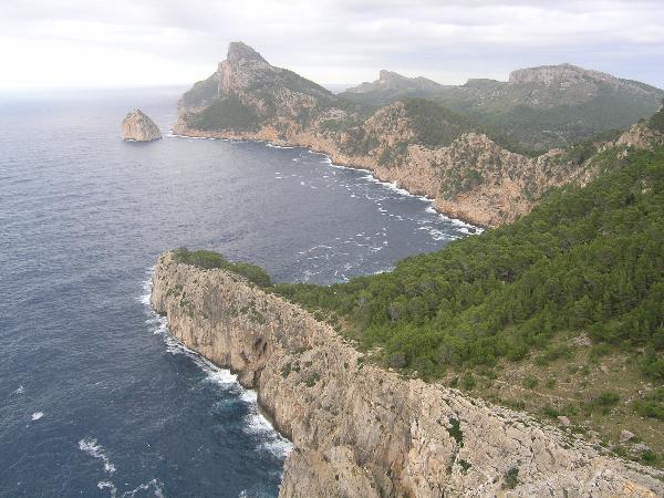
The peninsula Formentor in the North of Mallorca is a geological sensation. It dives out of sea with needle-pointedly steep cliffs and hugh mountains. In between there are lying fertile valleys. The name Formentor originates from the latin word Frumentorum (cereals).
The peninsula Formentor is a foothill of the Serra de Tramuntana. The last one dominates the whole west- and northwest of Mallorca and reaches it maximum in Puig Major (1445m), the highest mountain of Mallorca.
The origin of the tectonical structure of the Baleares correspond to those of a alpine one. The Baleares are a piece of a circummediterain alpidish system of fold mountains, which reaches as a hugh bend from the betish cordilleres of Southern Spain far into the mediterain sea. The proove for that was brought only a few years ago with the finding of dark slate and sandstones from the carbon area.
Mallorca consists up to 90% of limestones. Before the big continantal drifts in the late middleages of earth the island was a hugh flat area. Because of the continental drifts the hugh carbonate stones ( depositions of the Trias and Jura area) were torn to pieces and pushed on top of each other, so that the Tramuntnana folded upwards. Through tectonical influences the stones were transported from their original place and tilted. The steep slopes point to Northwest and build there those markant cliffs. The flattenings out point to Southeast and move on to the central basin.
At the cape de Formentor you could see those a few hundred of meters thick and pushed up stones very clearly. Those compact limestones weather at the surface often in a caracteristical pattern of grooves and ridges which are called „Karren“. At first there is a chemical exhaustion, which will later erose further under the mechanical influences of spray, rain and meltwater.
At the vista point Punta de la Nao, on the way to cape de Formemtor, there are forms of Karren in stripes and bowls.
To log this cache as a found
1.) upload a foto which shows you at the given koordinates (Mirador Punta de la Nao = Mirador Es Colomer, this task is re-allowed by GC since June 2019).
2.) At the given koordinates you will find a information sign with the altitude. Compare this with the altitude showed by your GPS and mention the difference in your log.
3.) Draw a picture of the steep coast looking towards the Cape and add it to your log or upload two other photos: one with striped and one with bowl shaped forms of Karren.
If your log does not contain the required uploads, your log will be deleted without comment. 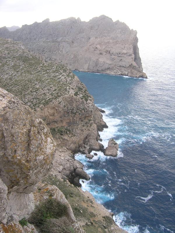
Deutsche Fassung:
Hinweis: Der Weg zum Mirador ist nur größtenteils abgesichert. Passt auf eure Kinder auf.
Parkplatz: Großer Parkplatz direkt an der MA-2210
Die Halbinsel Formentor im Norden Mallorcas ist eine geologische Sensation. Sie taucht aus dem Meer mit nadelspitzen Steilklippen und gewaltigen Bergmassiven auf. Dazwischen liegen fruchtbare Täler. Nicht umsonst leitet sich der Name Formentor von dem lateinischen Wort Frumentorum (Getreide) ab.
Die Halbinsel Formantor ist ein Ausläufer der Serra de Tramuntana. Letztere nimmt den gesamten West- und Nordwestteil Mallorcas ein und steigt am Puig Major, der höchsten Erhebung Mallorcas, bis auf 1445m empor.
Der Ursprung des tektonischen Aufbaus der Inselkette der Balearen entspricht dem eines alpinen Bauplans. Die Balearen sind das Bruchstück eines zirkummediteranen alpidischen Faltengebirgssystems, welches als ausgedehnter Gebirgsbogen, von den Betischen Kordilleren Südspaniens ausgehend, weit in das Mittelmeer hineinragt. Der Beweis dafür konnte erst vor einigen Jahren durch das Auffinden von dunklem Schiefer und Sandsteinen aus der Karbonzeit mit Gewissheit erbracht werden.
Mallorca ist bis zu 90 Prozent verkalkt. Vor den großen Kontinentalverschiebungen des späten Erdmittelalters präsentierte sich die Insel als ein große Fläche ebener Sedimente.
Im Zuge des Kontinentaldrifts wurden die mächtigen Karbonatgesteine (Ablagerungen aus der Trias und Jura-Zeit) regelrecht zerfetzt und übereinander geschoben, so dass sich die Tramuntana auffaltete. Durch die tektonische Einflüsse sind diese Gesteinskomplexe aus ihrer ursprünglichen Lage transportiert und gekippt worden. Die steilen Flanken zeigen nach Nordwesten und bilden dort die markanten Steilküsten. Die Abflachungen zeigen nach Südosten und gehen in das zentrale Becken über.
Am Cap de Formentor, wo die Faltensättel wieder unter den Meeresspiegel abtauchen und sich Felsvorsprünge ausgesprochen landschaftlicher Schönheit zeigen, lassen sich die mehreren hundert Meter dicken, übereinander geglittenen Gesteinspakete besonders gut beobachten. Die kompakten Kalkgesteine verwittern an der Oberfläche gerne in einem charakteristischen Muster von Rinnen und Graten, die Karren genannt werden. Es handelt sich zunächst um chemische Auslaugungen, die dann durch Gischt, Regen- und Schmelzwasser mechanisch weiter ausgewaschen werden. Am Aussichtspunkt Punta de la Nao, auf dem Weg zum Cap de Formentor, sind sowohl streifige als auch napfförmige Karrenformen ausgebildet.
Um diesen Cache als Found loggen zu dürfen,
1.) Füge deinem Log ein Foto bei, welches dich an den oben angegebenen Koors (Mirador Punta de la Nao = Mirador Es Colomer, von GC wieder erlaubt seit Juni 2019 ) zeigt.
2.) An den oben angegebenen Koordinaten findest du eine Höhenangabe. Vergleiche sie mit der Höhenangabe auf deinem GPS und erwähne die gegebenenfalls vorhandene Abweichung in deinem Log.
3.) Zeichne die Steilküste mit Blick zum Kap und lade deine Zeichnung in deinem Log hoch oder füge deinem Log zwei weitere Fotos bei: ein Foto von einer Stelle mit den oben erwähnten gestreiften, das andere mit napfförmigen Karrenformen.
Logs ohne die erforderlichen Uploads werden kommentarlos gelöscht.
Und falls dies mindestens dein vierter unserer Mallorca-Caches sein sollte, darfst du unsere MallorGeoCoin discovern. Code in unserem Profil.
Quelle: http://geo-aktuell.com/homepage2/Mallorca.html