Dutch version:
Let op! De vragen zijn aangepast m.i.v. 7 mei 2012.
Het Engbertsdijksvenen is een uitgestrekt veengebied met heideterreinen en vennen. Een restant van het grote veenmoeras dat ooit het noordoosten van Nederland bedekte. Van de oorspronkelijke grootte van 1000 hectare is momenteel nog zo’n 12 hectare in oorspronkelijke staat over gebleven. Daar in de kern is het veenpakket maximaal 6,3m dik.
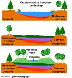
Het Engbertsdijksvenen is ontstaan na de laatste ijstijd in Nederland, het Weichselien. Tijdens deze ijsperiode die duurde van 116.000 tot 11.500 jaar geleden was er in Nederland sprake van een pool woestijn of ook wel een Arctische woestijn. Overal in de grond was sprake van permafrost. Het einde van het Weichselien betekende de inzet van een warmere periode. Door het smeltende water ontstond hier een landschap van hoogtes en slenken. In de slenken bleef het water staan doordat een voor water ondoordringbaar keileempakket op de bodem lag. In het water groeiden waterplanten en riet. Na het afsterven kwamen deze afgestorven planten op de bodem van de slenk terecht en vormden zo door de jaren heen een dik afvalpakket. In de zuurstofarme omgeving verteren de resten slecht en het plantenpakket wordt dan zo dik dat het boven het water uitkomt. Voorwaarde voor groei van het veen is dat er geen waterafvoer meer is die voor verdroging van het veen kan zorgen.
Door op het logo van SchoolTV Beeldbank te klikken wordt een nieuw venster geopend waarin een kort leerzaam filmpje afgespeeld wordt over het ontstaan van veen.

In de vijftiende eeuw werd reeds door de monniken van Sibculo begonnen met het afgraven van veen voor eigen gebruik. Later werd dit tijdens de industrialisering veel grootser aangepakt. Hele netwerken van smalspoor, waterwegen en wegen zijn vroeger aangelegd om de turf te kunnen vervoeren. Veel van het smalspoor in het gebied is door Staatsbosbeheer echter alweer verwijderd, ook zijn sloten en vaarten, die vroeger voor de afwatering moesten zorgen inmiddels alweer gedempt. Een mooi voorbeeld van eens een diepe sloot/ waterweg is te vinden op N52° 29.033’ E6° 39.562’.
Hier aangekomen is ook goed te zien hoe groot het hoogteverschil in waterstand is tussen de veenkern en de iets verder gelegen zandafgraving in westelijke richting. Voor wie nog veel meer wil leren over het veen en over het leven in en met het veen moet zeker een bezoek brengen aan het veenmuseum gelegen aan de Paterswal te Westerhaar-Vriezenveensewijk (N52° 26.816’ E6° 39.229’). Zie ook www.veenmuseum.nl
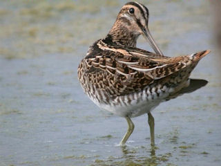
Was dit gebied vroeger het domein van de turfstekers, nu is het een gebied met veel watervogels, steltlopers en andere dieren en planten.
Een staatsnatuurmonument, Wetland en Habitatrichtlijn in één. Het is daarmee een echt eldorado voor natuur- en vogelliefhebbers. En voor wandelaars, voor wie aantrekkelijke routes zijn uitgezet.
Zie ook wandelnetwerk Twente (www.wandelnetwerktwente.nl) Het gebied is zowel vanaf de noordzijde als de zuidzijde toegankelijk. Vanaf deze parkeerplaatsen voeren gemarkeerde routes door het gebied. Het verdient de aanbeveling om te starten vanaf de noordzijde. Als je start vanaf de zuidzijde moet je rekening houden met een flinke wandeling. Maar zeer zeker de moeite waard! In het gebied zijn veel bijzondere dieren en planten te zien, dus verrekijker en fototoestel meenemen.
Op coördinaat N52° 29.440’ E6° 39.969’ is de informatieboerderij van Staatsbosbeheer te vinden en tevens een watermeter met enkele informatieborden.
Om de cache te kunnen loggen moet je het volgende doen:
Onderweg kom je langs een watermeter (N 52° 29.440 E 006° 39.969 ), maak hier een foto van de watermeter en plaats deze bij je log. Geef in je mail met de antwoorden op de onderstaande vragen tevens de hoogte van de waterstand door (vraag d).
Niet verplicht, maar wel heel erg gewaardeerd. Op de volgende coördinaten (N52° 28.962’ E6° 40.058’) maak je een foto van jezelf of je gps met het laatste restant oorspronkelijk veen op de achtergrond.
Stuur een mail met de antwoorden op de volgende vragen:
a. Welk soort veen is in dit natuurgebied te vinden?
b. Met welke snelheid groeit dit veen en van welk plantje is het veen sterk afhankelijk?
c. Hoe worden de zandkoppen genoemd die her en der uit de grond steken en waarnaar verschillende plaatsen in de omgeving genoemd zijn?
d. Geef de waterstand door van de watermeter
e. De bonusvraag!
In de buurt van N52° 29.020’ E6° 39.620’ en N52° 28.990’ E6° 39.730’ zijn twee grote schuin weglopende rechthoekige gaten in de grond te vinden.
Deze gaten zijn door mensenhanden gemaakt en hadden een specifieke functie. De vroegere functie is echter niet meer direct af te leiden aan de huidige situatie.
Vertel me waarvoor of hoe de gaten zijn gebruikt
Het antwoord op de bonusvraag is niet te vinden in het gebied zelf. De toezichthouders/ medewerkers van Staatsbosbeheer als ook de "oudere" bewoners uit de omgeving weten het vaak wel. Dus kom je iemand tegen...
Hieronder de banner die je mag gebruiken als je dat leuk vindt:

met de volgende code:
< a href = “https://coord.info/GC1H7GB“ > < img src="http://imgcdn.geocaching.com/cache/9afe0f9e-8a4a-4d53-b41d-3e6e9423e707.jpg"/ >
Deze Earthcache is met de welwillende medewerking van Staatsbosbeheer tot stand gekomen.
Voor informatie en rondleidingen:
Staatsbosbeheer Engbertsdijksvenen
Dorpsstraat 1A
7694 AA Kloosterhaar
0523-241453

" English version:
The Engbertsdijksvenen are a vast peat area with heath land areas and peats. A remainder of the large peat marsh that once covered the North east of the Netherlands. Of the original size of 1000 hectares at present day only 12 hectares have remained in original state. There in the core the peat parcel has a maximum thickness of 6,3 meters.
The Engbertsdijksvenen have arisen after the last ice age in the Netherlands, the Weichselien. During this ice age (or better called a glacial) which took place from 116.000 till 11.500 years ago the area was like an arctic dessert. The ground was constantly frozen (permafrost). By the time the Weichselien ended a warmer period started. Melting water created a landscape of altitudes and gutters. In the gutters water stayed behind because of a impenetrable layer of boulder clay on the sand floor. In the water reed and water plants grew. After dying the decaying plants remained on the floor of the gutter en created over the years a thick layer of debris. In a poor oxygen surrounding plant rests decay poorly and the layer of plant rests becomes so thick that it arises over the water level. Under condition that there is no outlet of water, which causes the peat to dehydrate, the peat can grow.
After dying these dead plants sank on the floor of the gutter and formed this way over the years a thick detritus parcel. The plant parcel becomes then so thick that it ends up above water. Because of this particular plant it can establish itselves. These plants sour the water still further, as a result of which, dead plants becomes preserved.
The literally spoken text from the videoclip from SchoolTV Beeldbank:
On small places in Noord Brabant and in the northern part of our country is the ground type Raised Bog found. The raised Bog is for a large part dug up, but on some places we can still see it. This is that Raised Bog. But what kind of ground type is it actually? How has it arise? For that we must go back in time thousands of years. The Netherlands existed for a large part of marsh and forests. Plants that died in that time, got under the water of the marsh. When plants are under water they are not accessible for oxygen. Because of this they can’t decay and many parts remain on the marsh floor. In time they form a new layer of soil, on which new plant scan grow again. The layer of plant rests continues to grow higher and higher. On a certain moment the layer gets above water level and again a new floor has arisen. On this floor plants and trees continued to grow and that is what the raised blog areas are.
In the fifteenth century the monks of Sibculo already started with digging up peat for personal use. Later this was more spectacularly tackled during the industrialization. Complete networks of narrow gauge, water ways and roads for transport of peat have been build in former days. Much of the narrow gauge in the area has been removed by Staatsbosbeheer, also are the waterways, which had to ensure the drainage in former days, be subdued. A nice example of once a deep ditch is on N52° 29,033’ E6° 39,562’. Arrived here is good to see how the unevenness in water cog between the peat core and the sand levellingpit a little bit further to the west.
Those who still wants to learn more concerning the peat and the life in and with the peat should certainly pay a visit to the peat museum, located at the Paterswal in Westerhaar-Vriezenveensewijk.
(N52° 26.816’ E6° 39.229’). See also www.veenmuseum.nl
This area was in former days the field of the peatdiggers, now it is an area with much wildfowl, stilt-walkers and other animals and plants. A state nature monument and Wetland in one. It is with that, a real Eldorado for nature- and birdlovers. And for walkers, for whom attractive routes have been made. Also see Wandelnetwerk Twente.
www.wandelnetwerktwente.nl
The area is both as from the North side and the south side accessible. As from these parking places marked routes start. It is recommended to start from the North side. If you start from the south side it is a considerable walk. But certainly worth while! In the area much particular animals and plants to see, therefore you should take your binoculars and camera.
On coordinate N52° 29,440 E6° 39,969 you’ll find an information farm and also a water meter with some information signs.
To log the cache you must do the following:
Go to the following coordinates (N52° 28,962 E6° 40,058) and make a photograph of yourself with gps clearly visible in one hand. On the photograph must be visible: The last remainder original peat
Send a mail with the answers on the following questions:
a. Which type peat is found in this area?
b. At which speed does this peat grow and of which small plant is the peat strongly dependent?
c. How are the sandheads called which arise in these surroundings, and which names are also found in several places in the surroundings?
d. Which level in cm does the watermeter show?
e. Anyone who knows the answer to the bonus question can obtain the most wanted banner and use in its profile and on his Internet site. A link to the banner is then sent by mail. In the area of N52° 29,020’ E6° 39,620’ and N52° 28,990’ E6° 39,730’ are two large slantingly rectangular holes in the ground. These holes have been made by man and had a specific function. However the former function is no longer directly to be understood at the current situation.
So tell me what you think It was.
This Earthcache was made with the willing coöperation of Staatsbosbeheer.
For information and guided tours:
Staatsbosbeheer Engbertsdijksvenen
Dorpsstraat 1A
7694 AA Kloosterhaar
0523-241453