From the guidelines, as from January 2013: "People do not need to wait for permission to log your EarthCache. Requiring someone to wait is not supported by the EarthCache guidelines. People should send their logging task answers to you, then log your EarthCache. When you review their logging task answers, if there is a problem, you should contact them to resolve it. If there is no problem, then their log simply stands."

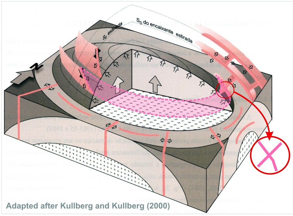
The Sintra Massif or batholith is a circular intrusion dating to ca. 90-80 M.a. into Mesozoic sediments that is made up of a central syenitic ring surrounded by an outer, large, granitic ring and a discontinuous outer gabbro-diorite ring that is better exposed in the south.
This disposition reflects the installation of two distinct diapirs: the first of granitic composition with crustal affinities and the second of gabbro-syenite composition with mantle affinities occupying the nucleus of the first diapir.
The upwelling of these diapirs resulted in a dome structure that generated several fault systems that were subsequently filled with felsic material.
Three types of faults were developed:
1 - Following the main intrusion occur the formation of open subvertical radial faults.
2 - Cone-like faults parallel to startification. These faults, associated with the intrusion of the granitic diapir acted as tension gashes. These are subparallel to sedimentary bedding and developed a sill complex that dip away from the massif in the east.
3 - Conical fractures associated with the intrusion of the second gabbro-syenite diapir dip towards the nucleus of the massif and acted as open reverse faults. These are mainly located in the south and south east of the intrusion and originated a complex system of felsic dykes.
The intersection of the any of these faults systems, today filled with felsic material, would yield dykes with a cross-cutting relationship. Given the right conditions and the right angle of cut you could end up with dykes in the shape of X’s or any other form in between.
If you imagine the intersection of a subvertical radial fault with a conical one, you can generate an X if you then observe it in section (See diagram).
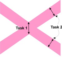 At the coordinates you will be confronted with two felsic dykes at approximately right angles to each other so that it forms an almost perfect X.
To claim this cache you have to perform the following tasks:
1 – Measure, or at least estimate, the vertical thickness of the central portion of the X,
2 – Measure, or at least estimate, the thickness of the western arms of the X, and
3- Tell me which dyke was intruded first and which was intruded second. The one going from bottom right to top left or vice versa?
Send me the answers through my GC profile to validate your find and I hope that you have enjoyed the scenery.

A estrutura da intrusão magmática que compõe o Maciço de Sintra é complexa mas pode ser descrita, sinteticamente, como um núcleo de natureza sienítica envolvido por um largo anel granítico e por um anel gabro-diorítico descontinuo; este encontra-se melhor representado a sul, onde se dispõe entre os sienitos e os granitos e é bastante 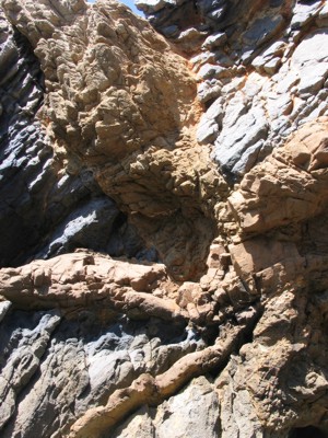 mais reduzido a norte, onde aflora perifericamente em relação ao anel granítico. Esta disposição reflecte a instalação de dois diapiros magmáticos distintos: o primeiro de composição granítica com afinidades crustais e o segundo de composição gabro-sienítica com afinidades mantélicas, ocupando, grosso modo, o nuc1eo do primeiro diapiro.
A ascensão deste magma gerou diversas falhas e fracturas, hoje preenchidas por material félsico.
Reconhecem-se 3 tipos de falhas:
1. Falhas radiais, subverticais abertas,
2. Falhas em cone paralelas à estratificação que associadas à intrusão do diapiro granítico actuaram como fendas de tracção. São paralelas a S0 (estratificação dos sedimentos) e desnvolveram um complexo de filões camada (soleiras) que inclinam para fora do maciço.
3. Fractures em cone associadas à intrusão do segundo diapiro de gabro-siénito que actuaram como falhas inversas abertas. Estão localizadas principalmente no S e SE e originaram um complexo sistema de diques félsicos.
O “X” resulta da intersecção de dois destes sistemas de falhas: as subverticais e cónicas que depois de preenchidas por magma liquido dão o efeito visto no local. Para perceberam melhor vejam o esquema apresentado.
A cache: Nas coordenadas encontrarão um “X” quase perfeito. Para conseguirem fazer o found desta EC têm umas simples tarefas pela frente:
1 – Estimem a espessura vertical no meio do X,
2 – Estimem a espessura dos braços oeste do X,
3- indiquem qual dos filões se implantou primeiro. O que vai de do canto inferior direito ao canto superior esquerdo ou vice-versa? e finalmente,
(Enviem-me as respostas por mail para validar o found e espero que tenham gostado da paisagem)
Divirtam-se!
 The most exciting way to learn about the Earth and its processes is to get into the outdoors and experience it first-hand. Visiting an Earthcache is a great outdoor activity the whole family can enjoy. An Earthcache is a special place that people can visit to learn about a unique geoscience feature or aspect of our Earth. Earthcaches include a set of educational notes and the details about where to find the location (latitude and longitude). Visitors to Earthcaches can see how our planet has been shaped by geological processes, how we manage the resources and how scientists gather evidence to learn about the Earth. To find out more click HERE.