GEOCACHE “DE KWEN”
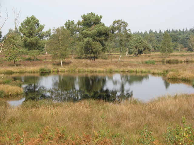
“Het Quin” of “De Kwen”zoals deze mooie plek in de volksmond in Afferden wordt genoemd, was oorspronkelijk een zandduin met een aantal vennen in het 800 hectare grote Bergerbos. Tegenwoordig maakt het onderdeel uit van een 110 hectare groot heidegebied waarin runderen en geiten meehelpen dit gebied open te houden.
Het Bergerbos is een onderdeel van het 5323 hectare grote Nationaal Park “De Maasduinen”. Dit park dankt zijn naam aan de opvallende stuifzandruggen die paraboolduinen worden genoemd. Deze paraboolduinen zijn ontstaan tegen het einde van de laatste ijstijd. Grote delen van Noord- en Midden-Limburg waren toen bedekt met een laag dekzand. Door de wind werd dit zand opgeblazen tot zandruggen en hoefijzervormige duinen. De “Kwenseberg” is met z’n 30 meter boven NAP een van de vele rivierduinen in dit gebied.
Staatsbosbeheer heeft in het Bergerbos, de Afferdense bossen en de Duvelskuul, zo'n 30 hectare bos gekapt om de 3 heide-eilandjes met elkaar te verbinden: "Het Quin" (oftewel "De Kwen") in het noorden, "De Cokse Hei" in het midden en ("De Duvelskuul") in het zuiden van de Afferdense bossen. Aan hei en open zand zijn diverse plant- en diersoorten gebonden. Vogels als nachtzwaluw en boomleeuwerik, amfibieën als hagedis, knoflookpad, heikikker en rugstreeppad, insecten als blauwvleugelsprinkhaan, diverse heidevlinders en -libellen doen er hun voordeel mee. De deelpopulaties ervan kunnen zich dan door het hele gebied verspreiden. Uiteindelijk zal een nieuwe ecologische verbindingsstrook ontstaan, bestaande uit een bosheidelandschap. Er is nog 10 à 25 procent bos over.
De Kwen wordt veel bezocht door wandelaars en is een onderdeel van een etappe van het Pieterpad. Het Pieterpad voert van Pieterburen in Noord Groningen naar de Sint-Pietersberg in Zuid Limburg en is daarmee de langste aaneengesloten wandelroute van Nederland.
Deze 5.5 km lange tocht gaat over bospaden met soms los zand of modder en kan eigenlijk alleen maar te voet uitgevoerd worden en is niet toegankelijk per rolstoel. Onderweg wordt meerdere malen een gebied ingegaan met loslopende geiten en runderen. Deze kunnen onvoorspelbaar reageren als je te dicht in de buurt komt. Houd hier rekening mee! Verder is er geen toegang met loslopende honden en na zonsondergang.
Parkeer je cachemobiel op WP1: N51°38.959' E006°00.630'
(Voor diegenen die onbekend zijn in dit gebied: Neem de afslag ter hoogte van Tuincentrum Verheijen op de N271.)
Bij WP1 kan tevens antwoord gevonden worden op de eerste vraag:
Hoeveel km is de rode wandelroute? Rond dit af op hele km.
Antwoord = A
Ga nu naar WP2: N51°38.910' E006°00.767' en vergeet vooral niet van het uitzicht te genieten.
Tel het rijtje extra schroeven.
Antwoord = B
Verlaat nu “De Kwenseberg” en vervolg je weg naar WP3: N51°38.835' E006°00.978'.
Welke kleur heeft het routebordje onder het paarse routebordje?
Tel het aantal letters van deze kleur.
Antwoord = C
Gebruik de paden om bij WP4: N51°38.740' E006°01.212' te komen.
Noteer het nummer van het knooppunt.
Tel nu van dit nummer alle cijfers op en deel dit door 3.
Antwoord = D
Ga dan naar WP5: N51°38.563' E006°01.757' en rust maar uit op het bankje met uitzicht op “Het Zevenboom ven” oftewel “De Zeuvenbeum”.
Neem de woordwaarde van de leverancier van het bankje en stapeltel de uitkomst.
Vermeerder deze som met 3. (Het antwoord op deze vraag is tijdelijk niet te vinden en krijg je daarom kado: E=4)
Antwoord = E
Zet ‘m dan in de bergversnelling en ga naar WP6: N51°38.673' E006°01.924'.
Hier staat een routepaal met rode bordjes. Tel het aantal schroeven in deze paal.
Antwoord = F
Al slingerend vervolg je de weg naar het hoogste punt van de maasduinen; WP7: N51°38.801' E006°01.697'.
Met goed weer kun je vanaf hier tot 30 km ver kijken.
Deze constructie is op Hemelvaartsdag opgeleverd. In welk jaar was dat?
Tel van dit jaartal alle cijfers op.
Antwoord = G
Daal nu af naar WP8: N51°38.857' E006°01.730'.
Een van de laatste woorden op het bovenste bord is een diersoort. Hoeveel letters heeft dit woord?
Antwoord = H
Ga verder naar WP9: N51°38.920' E006°01.827' .
Welk nummer heeft dit ruiterknooppunt?
Stapeltel dit nummer en verminder de uitkomst met 2.
Antwoord = I
Gebruik nu weer de paden om bij WP10: N51°38.951' E006°01.336' te komen.
Tel het aantal horizontale rijen schrikdraad.
Antwoord = J
Vervolg je weg naar WP11: N51°38.823' E006°01.207'.
Zoek de bout met de letters 'TY' en stapeltel de nummers eronder.
Antwoord = K
Voor de laatste vraag ga je naar WP12: N51°38.944' E006°01.092'.
Hoeveel banken van Staatsbosbeheer staan hier?
Antwoord = L
De cache ligt nu op N51°(A-J)(C+E).LGB' E006°(I-J)(H-B).D(F-K)L'
Ga tenslotte via WP13: N51°39.145' E006°01.008' weer terug naar je cachemobiel.
Als je alle 3 de caches (De Kwen, De Duvelskuul & De Cokse Hei) hebt bezocht, dan mag je onderstaande banner aan je profiel toevoegen.
Bannercode:
<p><a href="http://coord.info/GC6JJPP"><img src="https://s3.amazonaws.com/gs-geo-images/6dd1ccae-b1a2-40e5-b0ac-86279550e05b.jpg"></a></p>
ENGLISH VERSION
“Het Quin” or “De Kwen”, as called by the local inhabitans, was originally a river dune with some fens in the forest called "Bergerbos" covering approximately 800 ha. In these days this place is a part of a 110 ha. sized heathland area in which galloways and goats are helping to keep this area open.
The "Bergerbos is part of the national park "Maasduinen", founded in 1996 and covering approximately 5300 ha. The landscape consists of forests and heathlands on a sandy plateau along the river Meuse close to the German border. The present characterics of the park are strongly influenced by an intense interplay of wind, water and humans through the course of time, resulting in a unique pattern of drifting sand ridges or parabolic dunes which date from the last glaciation. Besides heathlands and forests, there are several fens in the park. The "Kwenseberg" dune is about 30 meters above sea level.
Staatsbosbeheer (a Dutch organization founded in 1899 to control and conserve Dutch nature reserves) has cut down about 30 ha. trees to connect 3 islands of heathlands. These islands are called "Het Quin" ("De Kwen") in the north, "De Cokse Hei" in the middle and ("De Duvelskuul") in the south of the Afferden forest. The natural rejuvenation of this forest lead to new flora and fauna like some reptiles and amphibians species. Among the flora we find several oak species, birch, pine, alder and beech.
"De Kwen" will be visited frequently by hikers and is part of the "Pieterpad". The Pieterpad is a long distance walking route in the Netherlands. The trail runs 485 kilometres (301 mi) from Pieterburen, in the northern part of Groningen, south through the eastern part of the Netherlands to end just south of Maastricht, on the top of Mount Saint Peter (St Pietersberg).
This geocache trail is about 5.5 km and uses small sandy forest trails with sometimes mud and can only be done by foot. The area is not accessible for wheelchairs. Along the way you enter several times an area with galloways and goats. These animals can response unpredictable if you come too close. So keep this in mind. Furthermore there is no access to this area for unattached dogs and after sunset.
Park your cache vehicle on WP1: N51°38.959' E006°00.630'
(For those who are not familiar in this area, take the turn on the N271 road nearby garden center Verheijen.)
At WP1 you can also find the answer to the first question.
How many km is the red walking route? Round this up to whole km.
Answer = A
Go to WP2 N51°38.910' E006°00.767' and don't forget to enjoy the view.
Count the number of extra screws in a row.
Answer = B
Now leave the "Kwenseberg" dune and follow the path down to WP3: N51°38.835' E006°00.978'.
What color is the route sign under the purple route sign?
Count the number of letters of this color.
Answer = C
Use the trails to get to WP4: N51°38.740' E006°01.212'.
Take the number of the intersection (knooppunt).
Add up from this number all individual digits and divide the result by 3.
Answer = D
Than go to WP5: N51°38.563' E006°01.757' and take some rest on the wooden bench with a view to "De Zeuvenbeum" lake.
Take the word value (digital root) of the supplier of the wooden bench and increase the result by 3. (The answer to this question is temporarily unavailable, that's why you got this for free now: E=4)
Answer = E
Now go uphill to WP6: N51°38.673' E006°01.924'.
Here stands a pole used for routing with red signs. Count the number of screws in this pole.
Answer = F
Along a twisted trail you will find the highest point of the "Maasduinen" area; WP7: N51°38.801' E006°01.697'.
If the weather is clear, you have a view up to 30 km.
This construction has been delivered on Ascension Day. In which year?.
Add up all individual digits.
Answer = G
Go downhill to WP8: N51°38.857' E006°01.730'.
One of the last words on the uppersign is about an animalspecies (in dutch). At how many letters consists this word?
Answer = H
Go further to WP9: N51°38.920' E006°01.827'.
What number does this horse rider junction have?
Digitsum this number and reduce the result by 2.
Answer = I
Use the trails to find WP10: N51°38.951' E006°01.336'.
Count the number of horizontal electric wires.
Answer = J
Continue to WP11: N51°38.823' E006°01.207'.
Find the bolt with the characters 'TY' and digit sum the numbers underneath.
Answer = K
For the last question you have to go to WP12: N51°38.944' E006°01.092'.
How many wooden benches labeled "Staatsbosbeheer" are placed here?
Answer = L
You can find the stash on N51°(A-J)(C+E).LGB' E006°(I-J)(H-B).D(F-K)L'
Afterwards you can go back to your cache vehicle via WP13: N51°39.145' E006°01.008'.
If you have visited all 3 geocaches (De Kwen, De Duvelskuul & De Cokse Hei) you may add the banner below to your profile.
Bannercode:
<p><a href="http://coord.info/GC6JJPP"><img src="https://s3.amazonaws.com/gs-geo-images/6dd1ccae-b1a2-40e5-b0ac-86279550e05b.jpg"></a></p>