Flowerpot Island Earthcache EarthCache
Flowerpot Island Earthcache
-
Difficulty:
-

-
Terrain:
-

Size:  (other)
Please note Use of geocaching.com services is subject to the terms and conditions
in our disclaimer.
PLEASE NOTE THE LOGGING REQUIREMENTS AS ALL EARTHCACHES HAVE. FAILURE TO SEND ANSWERS BEFORE LOGGING OR WITHIN A REASONABLE TIMEFRAME WILL BE CAUSE FOR LOG DELETION.
This Earthcache is on Flowerpot Island, northeast of Tobermory at the end of the Bruce Penninsula. THE CACHE IS NOT AT THE POSTED COORDINATES, rather they are at the start of the Loop Trail at Beachy Cove which takes you around Middle Bluff on the island.
To access this Earthcache, you will need to either take the Blue Heron V ferry (a very cool trip which also passes over two shipwrecks in Big Tub Harbour) or you will need to boat or padddle the 6km from Tobermory to the public docks at Beachy Cove on the island. Please note that unless you are taking the ferry, you must dock at the public dock, not the ferry dock. See additional waypoints.
Flowerpot Island is part of the Fathom Five National Marine Park and was, at one time, simply a high point along the Niagara Escarpment which extended all the way across to Manitoulin Island. Water levels have fluctuated dramatically over the millennia and offshore from Flowerpot Island is evidence of an ancient waterfall that would have rivalled Niagara itself. Most of the trip over from the mainland is in about 30M of water but at the base of this “waterfall” the depth is 90M.
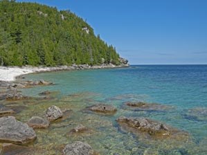
The key to Flowerpot Island and most of the Bruce Penninsula is the dolomite bedrock. This type of limestone, acted on by water in the form of glaciers, lakes, rain, and frost, has resulted in features such as the “flowerpots”, caves, raised beaches, and surface etchings. Dolomite is a soft rock that dissolves in water. As a result, its surface wears like melting ice. You will notice this especially in the surface pitting and in the caves.
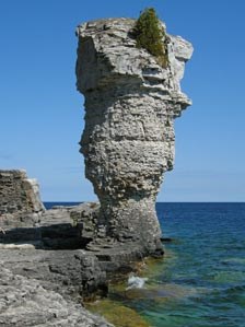
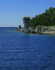
When at the Flowerpots themselves, you will notice the tops are wider and have thicker layers. When the lake levels were at this height, the cap rock resisted erosion but the surrounding rock did not. As the lake levels dropped, the erosion ate away lower and lower. These two formations now stand 12 and 7M high respectively and are set well back from the cliff face. Both flowerpots were capped with concrete and had mortar applied to their bases in the past in order to slow down erosion.
Another interesting feature on the loop trail is the main cave. Not far from the large flowerpot heading towards the lighthouse, you will climb the staircase into the cave. This cave is 14M above the current shoreline but was created by wave action 5,000 years ago when the water levels were much higher. The rock in this cave was once part of a chain of coral and sponge reefs on the bottom of a warm, shallow, tropical sea that once covered the area. This was the edge of ancient Lake Nipissing. The floor of the cave is made up of loose rock that was pried away from the ceiling by water freezing in the cracks of the rock.
As you continue on the trail, you will come to the lighthouse station. You will have to follow the concrete path to the east of the buildings to get to the site of the old lighthouse (and current light “tower”).
If you come by private boat, you will need to head for the ferry dock area in order to pay your park admission and start the trail which will take you to the appropriate locations to gather the data. Once you are ready to start out, you have two choices…stay on the loop trail and just head towards the flowerpots when you can to complete the tasks or do like we did and hike the rocky shoreline to get to the flowerpots. This was a lot of fun but may be more challenging at certain times of the year when water levels are higher.
Take some time and explore the lightkeeper’s buildings and museum. Don’t forget the “Loo with a View”! To get back to the docks, you can either retrace your steps or follow the trail past the “Loo” and head back via the inland part of the loop. This is a really nice hike as well through quite a diverse terrain.
LOGGING REQUIREMENTS
Please email me all answers BEFORE POSTING YOUR FIND. Once verified, you can log the find and upload your picture from number 3.
1) N45 18.068 W081 36.760 – How many big boulders here and what colour is the algae?
2) N45 18.092 W081 36.749 – Little Flowerpot…estimate its height
3) N45 18.201 W081 36.701 – Big Flowerpot… take a picture of someone in your party near the base of the flowerpot and holding your GPS unit
4) N45 18.233 W081 36.759 - Atop the rocks near the large flowerpot you will see picnic tables. The trail continues on behind them. Head up the trail towards the lighthouse and you will see the signs to the cave off to the left. Climb the stairs to the cave. As water moves down through the bluff it dissolves the rock. When it reaches the ceiling of the cave it leaves calcite behind before it drips down. What is the name of the small bumps that are formed? NOTE: The answer is NOT Stalactite or Stalagmite.
5) N45 18.431 W081 36.847 - Continue along to the lighthouse area and up to the light tower via the concrete path. The area where the original lighthouse was built on was known as Castle Bluff. What type of rock formation is Castle Bluff? How far is it from the top of Castle Bluff to the water?
Enjoy the adventure!
Additional Hints
(No hints available.)