The Gatineau Parkway is closed during the winter months and used
as a cross country ski trail. Call the Gatineau Park Information
and Ski Condition line at 819-827-2020 or 1 800 465-1867
(toll-free).
As you stand at the Champlain Lookout the whole of the Ottawa
Valley is displayed before you. But 11,000 years ago you would have
seen something completely different, the Champlain Sea, an inlet of
the Atlantic Ocean. The sea is thought to have been similar to the
present day James Bay region of Canada, a subarctic ocean dominated
by ice. Plant and animal communities in and around the Champlain
Sea were likely similar to those that exist near the present Gulf
of St. Lawrence, where beluga whales and several species of seal
still thrive.

During its maximum extent, the Champlain Sea covered an area of
over 20,500 square miles in portions of Ontario, Quebec, New York
and Vermont. This area includes much of what is now the St.
Lawrence River Valley, the lower Ottawa Valley and the Champlain
Valley.
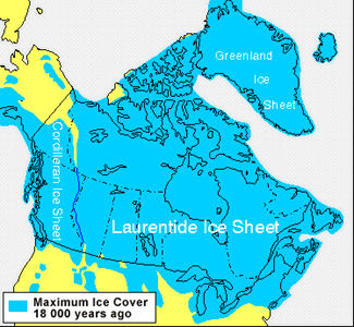
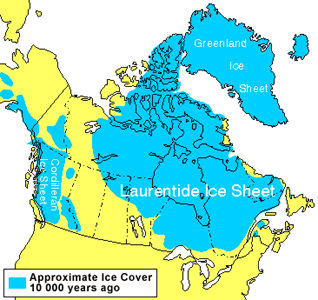
About 15,000 years ago the Wisconsin Glaciation, the last of
four major glacial periods to cover the Ottawa-Gatineau region,
reached its peak. The Laurentide Ice Sheet covered an enormous area
of eastern Canada with ice that was kilometers thick. The
tremendous weight of the glaciers caused the earth beneath them to
compress and subsequently sink. Immediately after the glaciers
retreated northward the land remained depressed for quite some
time, and global sea levels were rising with the melt waters,
allowing the ocean to overflow the land. As the ground level rose
up, a process called ‘isostatic rebound’ which is still
occurring in the Hudson’s bay area, the sea retreated. By
about 10,000 years ago the sea had entirely receded from its bay
and the current landscape of rivers and lakes formed.

To log this cache go to the posted co-ordinates and
photograph yourself with the Ottawa Valley in the background
and post this on your log. Then you must discover the answer to
these three questions and email them to me, Bluelamb03
1. How thick was the ice sheet that covered this region?
2. How deep was the Champlain Sea in this region?
3. What is the elevation of the Champlain Lookout now?