This earthcache is located at the Palisades Sill roadside
parking area on the north side of US Highway 64 within the boundary
of Cimarron Canyon State Park. The park is part of the 33,116-acre
Colin Neblett Wildlife Area, the largest wildlife area in New
Mexico. The Cimarron River flowing eastward past the Palisades is
well-known for eight miles of excellent trout fishing. The
earthcache is best completed during daylight hours.
Cimarron, New Mexico is famously situated "where the mountains
meet the plains." As you drive west from Cimarron into the Cimarron
Range of the Sangre de Cristo Mountains, most of the hillsides are
covered with soil, grasses, and trees. Notable exposed ledges and
cliffs formed from light-colored sheets of porphyritic dacite
include the Palisades and two formations at Philmont Scout Ranch:
Lovers Leap and Cathedral Rock, both of which are on private
property.
A sill is a type of igneous rock body that formed from volcanic
activity under the earth's surface, intruding between older rock
beds. Sills form parallel to surrounding rock and are usually
horizontal, although tectonic processes can alter their
orientation. The age of the Palisades Sill has been estimated as
between 26 million and 34.7 million years.
The porphyritic dacite of the Palisades is composed of
large-grained crystals (phenocrysts) of plagioclase feldspar,
biotite, hornblende, and quartz in a fine-grained gray rock
groundmass. One characteristic of porphyritic dacite is the large
number of cooling joints, which (especially evident in the
Palisades) caused the rock to crystallize into tall, thin columns.
An apron of broken rock at the base of the Palisades hints at the
effects of weathering and time.
How Tall are the Palisades?
Palisades up Cimarron
Conon 1000 feet high.
Cimarron, N. Mexico.
Despite the claims of this vintage postcard (postmarked in 1919),
the Palisades are not 1,000 feet taller than the Cimarron Canyon
floor. The elevation of the river at the base of the Palisades is
approximately 7,680 feet and the elevation of the cliffs visible
from the cache coordinates is approximately 8,000 feet, a
difference of just over 300 feet.
However, the terrain close to the Palisades climbs past 8,200 feet
and 8,400 feet, and the closest unnamed peak some 1,300 feet NNW of
the Palisades is 8,985 feet tall, so the postcard publishers may
easily be forgiven for their enthusiasm. |
 |
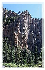
The Scenery
Much of what may be appreciated at the Palisades is visual; the
towering cliffs and wooded riverside create a cool, tranquil spot
that has served as a unique landmark for passersby. These historic
postcards and modern images highlight several principle features of
the Palisades area. All are located in the immediate vicinity on
the north side of US Highway 64.
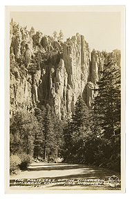
| The Palisades have
been featured on dozens of postcards over the last century. The
best-known commercial photographer to capture this classic view on
the approach from Eagle Nest was Burton Frasher, Sr. (1888-1955),
who traveled the Southwest taking thousands of photographs of main
streets, civic buildings, and scenic byways for his Frasher Foto
postcard line.
This postcard was published in 1935 and the
photograph was taken in 2008. |
 |
 |
|
The Devil's Mailbox is within sight
of the Palisades parking area northwest along the top of the
Palisades Sill. Although this 1938
Frasher's Foto postcard image was taken from a
different perspective (from the south side of the highway), the
post is clearly recognizable based on its relationship to the
surrounding terrain. |
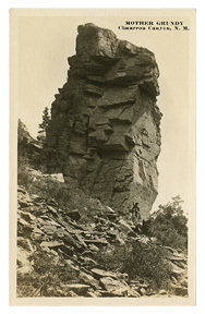 |
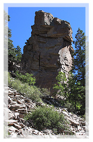
This enormous
formation seems to be perched precariously on a slope high above
the north side of US Highway 64 just southeast of the Palisades. It
was identified as "Mother Grundy" in one c1910-1930 postcard image;
note the person waving at the base. The formation appeared much the
same in 2008.
Mother Grundy is visible from these coordinates:
N 36° 32.226
W 105° 09.049 |
 |
|
The southeast end of the Palisades features rounded rock columns
distinctly different from the main formation. These columns
protruding above the treetops have been featured on postcards such
as this early view captioned "PALLICE. ADE N.M". |
................................................................................................................
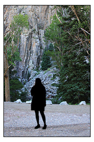 |
Sample Logging
Photo
Showing Palisades in
Background |
To Log this Earthcache
1) Visit the Palisades and
locate the Official Scenic Historic Marker at the
coordinates.
2) Have your photograph taken
at the site with your GPSr so that some portion of the distinctive
Palisades are visible, as shown in the sample logging photo. For
solo cachers, a photo of your hand holding your GPSr in front of
the Palisades is certainly fine. If your GPSr and phone are in one
unit (e.g., an iPhone with Geocaching app), a creative photo of
your choosing at the site is also acceptable. Please do not post
photographs of the scenic marker.
3) Immediately before logging
your find, e-mail the answers to the following three questions
using this link. Do not post the answers in your
log!
Question 1 - According to the scenic marker, of what rock type
is the Palisades Sill composed?
Question 2 - According to the scenic marker, how many years ago
were the Southern Rocky Mountains uplifted?
Question 3 - Looking northwest from the scenic marker to the top
of the Palisades, you should see The Devil's Mailbox. Using any
method at your disposal, estimate the height of the post itself
(not the elevation), and e-mail me your guess. If weather or other
conditions prevent you from seeing The Devil's Mailbox, please let
me know.
4) Upload your photograph(s)
when you log your find. Logs without at least one photograph will
be deleted, hence the (albeit modest) difficulty rating.
.................................................................................................................
Please follow all posted park rules and regulations during
your time in Cimarron Canyon State Park, and please do not disturb
any natural resources in this area. Some of the rules are
displayed on a covered signpost in the Palisades Picnic Area across
US Highway 64 from the Palisades. More information is available at
the park office in the Tolby Campground area approximately three
miles east of Eagle Nest. Fees are charged for some activities.
Information for this earthcache was gathered from several
sources, including the
Cimarron Canyon State Park web site and the
NMBGMR Geologic Tour: Cimarron Canyon State Park.
For a general treatment of Cimarron-area geology I highly
recommend: Robinson, G. D., et al. (1964). Philmont Country: The
Rocks and Landscape of a Famous New Mexico Ranch. [U.S.]
Geological Survey Professional Paper 505. Washington: US Government
Printing Office.
Creation of this earthcache was approved by the Cimarron Canyon
State Park staff.