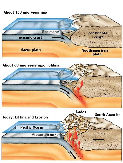
The present age of the mountains is estimated at about 60 million years. According to most scientific literature the formation of the mountain range only took about 3 million years.
The Andes resemble a standard example of plate tectonic processes of an ocean-continent-convergence. The movements were caused by the subduction of the Nazca plate benath the South American plate about 150 million years ago. At the subduction line – the boundary between both plates – we find now two deep sea trenches. The Peruvian oceanic trench is 6262 m b.s.l., topped by the Atacama trench which goes down to 8066 m below sea level. The orogenesis (mountain formation) started in the Tertiary (Jurassic Period), but most of the formation of the present appearenace took place in the Pleistocene (the Cretaceous Period). By faulting, folding and uplifting sedimentary and metamorphic rocks of the ancient cratons to the east. The lack of erosion lead to a stabilisation of the Andes-Orogen in the west. This is the reason why the the Altiplano is so wide.
Until today there are still various geodynamic processes in the formation of the Andes:
• Convergence movement up to 10 cm per year
• Vertical uplifting up to more than 1 mm per year
• Extreme thickness of the crust (60-70 km)
All the above mentioned processes lead to more compression and a continuation of the thickness ot the crust towards the East. Because the plates are still in movement the orogenic events are responsible for earthquakes and volcanic eruptions.
The Andes mountain range is host to a lot of active volcanoes; some of them the highest active ones in the world.
language-changed image from klett.de
Educational information:
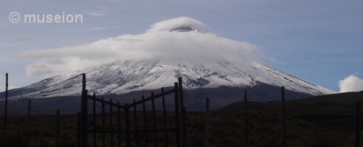
Cotopaxi is the second highest mountain in Ecuador. It used to be the highest active vulcano in the world until the Tupungato in Chile woke up in 1986. The highest volcano in the world is Ojos del Salado - also in the Andes but further south in the Atacama desert.
The name means Cone of Moon in Castillan.You will find Cotopaxi in the middle of a likewise named National park and the province of Cotopaxi, Pichincha, and Napo, east of the Panamericana between Quito and Latacunga. It rises about 3000 m above the surrounding area and on the summit you can measure a height of 5897 metres (19,347 ft) above sea level. Even though Alexander von Humboldt tried to climb it he reached only 4500 m. The first person to record reaching the top was Dr. Wilhelm Reiss, A.M. Escobar in 1872. Now the most used path up the mountain is the Whymper route.
The park was founded in 1979 and requires a fee of $10 to enter. On 33.393 hectares you will find the vegetation and fauna of a high andean climate above 3400 m. There are dear, pumas, condors, wild horses, and llamas - just to name a few animals found here. The vegetation is amazingly rich and I highly suggest to go to the museum to get more information. In order to claim this Earth cache you need to go there anyway.

Short history of volcanic activities:
| 1534 |
Eruption, Ashes, first recorded eruption because it happened while the natives were fighting with the Spanish. The geologic occurences caused panic amongst the intruders. |
| 1742 |
After years of inactivity suddenly 3 major eruptions, destruction of the Cutuchi river valley and the city of Latacunga |
| 1743 |
2 eruptions. The one on the 30th of November destroyed not only the Valleys of Cutuchi and Los Chillos, but also Latacunga again. It had also considerable side effects in the Amazon jungle. |
| 1766 |
Eruptions with emissions of ashes, lava and cinders. Again destruction of the Cutuchi River Valley and Latacunga. |
| 1768 |
Eruptions with lava flows and ash precipitation reaching as far as Guyaquil and Colombia. The Cutuchi River Valley was buried underneath ashes which reached until the Valley of Los Chillos and Tumbaco. Destruction of the city of Latacunga yet again. |
| 1803 |
Minor eruption |
| 1853 |
Lava: appearance of the flows of Manzana Huaico which were several kilometers long and Puca-Huaico on the western slope |
| 1863, 1866 |
Lava flows |
| 1877 |
4 eruptions; the one on the 26th of June destroyed a textile manufacture in Sangolqui and Latacunga |
| 1878 |
2 "Fire nuts", ash precipitation |
| 1979 |
3 ash eruptions, with extensive precipitation |
| 1880, 1882 |
ash eruptions |
1883, 1885,
1903, 1904 |
Lava and cinder flow |
| 1975 |
Cotopaxi experiences a sudden warm-up. The snow in the interior of the crater shrank to the point of disappearing completely. A few earthquakes were measured. |
Now on to your tasks here. Apart from the pictures which must be included in your log, please do not include the answers. Mail them to me instead. Though I speak Spanish it would be nice, if your log contains at least a bit of English.
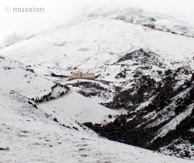
1. You need to have reached the hut José Ribas on the way up the mountain. This is not so difficult and you don't need to have extensive mountaineering experience. Look at your GPS - how high are you? Post a picture with you and your GPS (visible display with numbers) at this point. If you go up the mountain - congrats and please post a picture with you on the top (including your GPS).
2. Estimate the difference (in metres) between the beginning of the glacier and the hut. If this is not possible for whatever reasons, tell me what the sign behind the hut (towards the mountain) says.
3. There is a very educational and interesting little museum in the park. In order to learn more about this area I'd like you to go and visit it. There is no charge (at least not yet). Opening times (so far) 8-12 and 13-17. There is one table with "Volcanic Products". Make a picture of the according display. If this is not possible: they have a stuffed Andean condor there. Estimate the size of it.
4. There is a little path behind the museum where you have a nice view towards Cotopaxi. What does the sign at the beginning above you say?