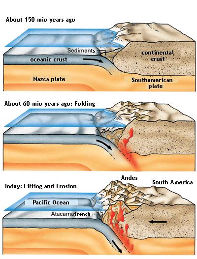
The present age of the mountains is estimated at about 60 million years. According to most scientific literature the formation of the mountain range only took about 3 million years.
The Andes resemble a standard example of plate tectonic processes of an ocean-continent-convergence. The movements were caused by the subduction of the Nazca plate benath the South American plate about 150 million years ago. At the subduction line – the boundary between both plates – we find now two deep sea trenches. The Peruvian oceanic trench is 6262 m b.s.l., topped by the Atacama trench which goes down to 8066 m below sea level. The orogenesis (mountain formation) started in the Tertiary (Jurassic Period), but most of the formation of the present appearenace took place in the Pleistocene (the Cretaceous Period). By faulting, folding and uplifting sedimentary and metamorphic rocks of the ancient cratons to the east. The lack of erosion lead to a stabilisation of the Andes-Orogen in the west. This is the reason why the the Altiplano is so wide.
Until today there are still various geodynamic processes in the formation of the Andes:
• Convergence movement up to 10 cm per year
• Vertical uplifting up to more than 1 mm per year
• Extreme thickness of the crust (60-70 km)
All the above mentioned processes lead to more compression and a continuation of the thickness ot the crust towards the East. Because the plates are still in movement the orogenic events are responsible for earthquakes and volcanic eruptions.
The Andes mountain range is host to a lot of active volcanoes; some of them the highest active ones in the world (Cotopaxi a little bit further north).
language-changed image from klett.de
Educational information:
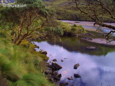
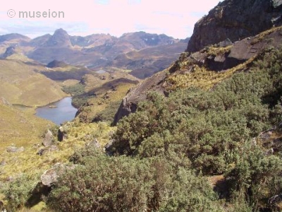
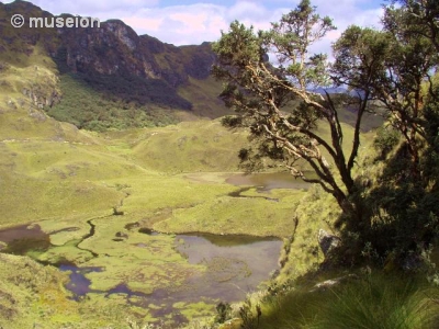
You will find Cajas about 30 km to the Northwest of Cuenca in the province of Azuay in the Ecuadorian Andes. It is one of the very good examples of the wide plateau-like mountainous regions. Due to the lack of declinations and the solid rock underground it withholds a lot of water.
The origin of the in the park dates back to the Mezozoic era (120 to 200 million years ago). The altitude of the plateau-like region varies between 3160 and 4450 metres above sea level. Since the vegetation of the Páramo can contain very much water and can even "feed" the springs in dry times the area holds a very important water reservoir. Additionally to the flora about 270 lakes and lagoons along with the underground water are the main source of drinking water for the nearby city of Cuenca. The lakes are mostly connected underground. The lagoons mostly date back to the Antropozoic era (1 to 2 million years ago) when the glaciers were formed. (The Mammoths still lived, and mankind originated and evolved slowly.) When the glaciers melted here in the mountains the valleys and lagoons were formed in the shape of boxes, or cajas. Hence the came of the area.
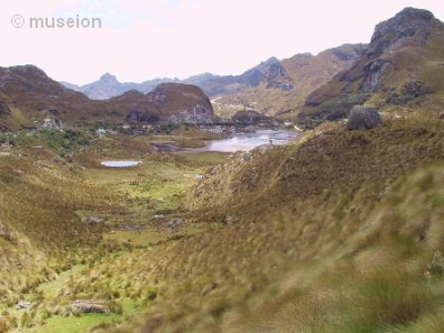
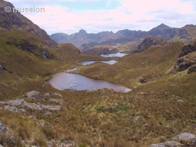
In 1996 Cajas with 28.808 ha was declared a National Park.
Apart from the astounding beauty of the surroundings, part of Cajas' fame comes from a supposed sighting of the Virgin (Virgen del Cajas). Therefore a lot of Christian believers come here to pray or ask for miracles.
The remains of almost a hundred villages and a few more minor settlements from the time before the Cañari have been found in the area as well.
Approximately 125 species of birds have been found here. A lot of the local flora and fauna are endemic and highly endangered. Among them the Great Andean Condor (only about 80 left in Ecuador) and the Violet-tailed Metaltail. In the lakes, you can also find Andean gulls, yellow-billed pintails and the speckled teal.
 There is also a large black and white raptor - the Curiquinga. The largest hummingbird of the world has it's residence in the agave flowers.
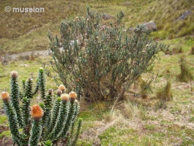
Parámo grass, Chuquiraga Jussieui, Valeriana rigida, Tillandsia, and Espeletia are prominent in the park as well. Especially the latter has an interesting life circle.
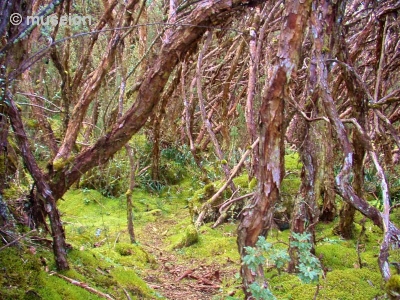
Among the vegetation are also some of the last remaining Polylepis forests in the park. Polylepis species, also known as Quinoa, frequently grow at or above the natural tree line in the Andes. Polylepis tarapacana is especially remarkable for being the woody plant occurring at the highest elevations worldwide. It forms monotypic stands at about 3,800 - 4,500 m.a.s.l., far above the natural treeline which is typically between 3,200 and 3,5000 m.a.s.l. The Polylepis forests are separated by the true treeline of the forests of the humid yungas or dry Interandean valles by shrubs or grasses of the puna.
 Polylepis is a genus of trees and shrubs restricted to the Andes of South America. Controversy exists between tropical ecologists whether its currently fragmented distribution is natural or the result of human land-use. Some scientists believe that much of the open grasslands of the Andean altiplano that currently separate isolated Polylepis forests were in fact one continuous forests before early native Andean peoples cleared or burned the ancient forests. This would also explain the remnants of the pre-Incan ruins in the area.
Polylepis forests now exist primarily as small, widely isolated fragments, which are being rapidly depleted by rural communities. Remaining Polylepis forests are used for firewood and building material and provide protection against erosion and habitats for endangered animals. In some countries - including Ecuador, conservation and reforestation measures are underway. The treelike plants belongs to the Rosaceae family and to the tribe Sanguisorbeae. They are wind-pollinated and can be recognized by its pinnate leaves and a multi-layered, papery bark. This unusual bark also prompted its scientific name, a combination of Greek and Latin meaning "many-scales".
It is possible to go trekking in the park. However, you must have good orientation. Your GPS should help you. If you are a fairly experienced hiker and have the appropriate acclimatisation you should be able to cross the park in two days. However, I strongly suggest to inform yourself of the appropriate clothing. There is no permanent snow but it is cold at night - sometimes reaching down to -8 °C. Hail or rain are not uncommon.
It is possible to camp in the park. However, please stay on the - admittedly - narrow paths anyway. The vegetation takes a long time to regenerate.
There is also an admission to the park. Please have $10 ready.
Now on to your tasks here. Apart from the pictures which must be included in your log, please do not include the answers. Mail them to me instead. Though I speak Spanish it would be nice, if your log contains at least a bit of English.
1. Look at your GPS - how high are you at the parking place? The one near the restaurant, leading directly through the area along the old Inca road connecting Cuenca with the Pacific? If you don't pass this street because you are hiking in another end, post me the altitude of one of the Quinoa forests with a picture of the display.
2. You have to post a picture in your log of you, your GPS, and a recognizable part in the park. Also, a picture with you inside or close to a forest of Polylepis is necessary. Yes, you can combine this with the first task.