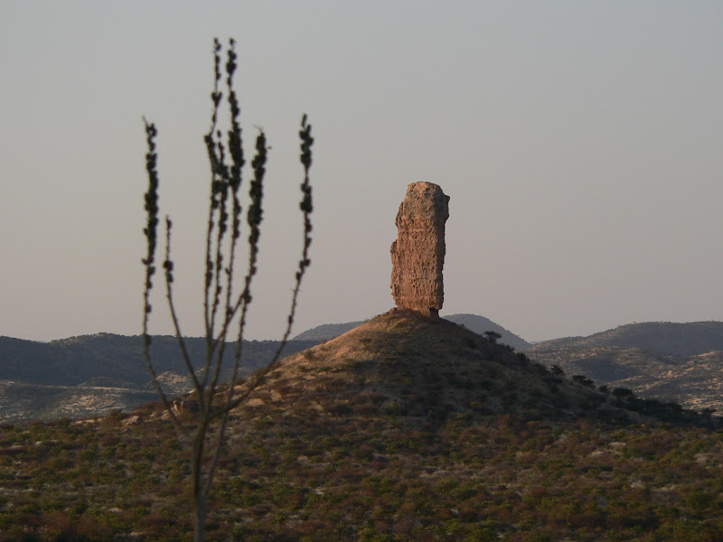
The finger cliff (afrikaans: Vingerklip) is
developed by erosion from the 30 million year old limestone layers
Monument in the proximity of the city Outjo in Namibia. It is about
35 meters high and has at its basis an extent of 44 meters. It is
in the Ugab valley. This river valley is developed in prehistoric
time, when the Ugab still led more water . Beside the finger cliff
still numerous further board mountains and remainder rock protrude
tallow approximately from that.
A board mountain, also Mesa mentioned
(Spanish: mesa = table, board), is a mountain with a far summit
level, which is usually a consequence of flatstoring sedimentary
rocks. Its mountain-slopes are often pronounced as steep rock
slope. The majority of the board mountains have in the sketch an
oblong form, i.e. the high surface has a smaller expansion in a
direction. Typical board mountains are e.g. in the
Elbsandsteingebirge, in addition, in the Frankish and Swabian Alb,
where they are the result of Schichtstufen. Another type are the
board mountains, whose summit corridor consists of a Lavadecke.
Here the mountain form is less a consequence of the flat
Sedimentierung, but the hardness of the rock. Well-known board
mountains are the board mountains in South Africa and Suriname,
further Ben Bulben, lily stone, Tepui, Szczeliniec Wielki and
Amba.
To log the cache you need the following
terms:
-
Make a picture of you in front of the
rock.
-
Answer the following
questions:
 Who ownes/manages the place where you can
find the rock? (Name of the Farm)
Who ownes/manages the place where you can
find the rock? (Name of the Farm)
Whats the hight of the
rock?
Tell in your own words the formation of a
board mountain and give some examples of other regions in the world
where you can find them.
After you have send the correct answers you
can log your visit...have fun! Don´t litter and respect
animals!
