The Paunsaugunt Plateau (pronounced "PAWN-suh-gant") is
dissected plateau, rising to an elevation of 7000 ft-9300 ft (2100
m-2800 m), in southwestern Utah in the United States. Located in
western Garfield County, it is approximately 10 mi (16 km) wide,
and extends southward from the Sevier Plateau approximately 25 mi
(40 km), terminating in the Pink Cliffs at the southern end. It is
drained by the East Fork Sevier River that flows northward on the
plateau, to the meet the main branch (Sevier River) that flows in a
valley along the western side of the plateau. The plateau
essentially marks the southeastern extreme of the Great Basin. Much
of the plateau is part of Dixie National Forest.
A diagram of the plateau
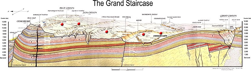
Geologically the plateau was created approximately 10-15 million
years ago by an uplift on the larger Colorado Plateau. The
uplifting caused the formation of joints along the side of the
plateau. Subsequent erosive forces, especially along the eastern
side in Bryce Canyon National Park, have resulted in the creation
of strange rock formations called hoodoos, which are the hallmark
of the park (see
Geology of the Bryce Canyon area).

The platau was dissected or created by movement along the
Paunsaugunt Fault that is located nearby. A fault is a fracture in
the ground along which movement occurs. There are three main types
of faults: Strike-slip, normal, and thrust (see the image). The
best known example of a strike-slip fault is the San Andreas Fault
in California. Movement along the San Andreas caused the great San
Francisco earthquake of 1906. The movement along a strike slip
fault is lateral, that is the land on either side of the fault
slides horizontally.
Normal faults form when the hanging wall drops down. The forces
that create normal faults are pulling the sides apart, or
extensional. Reverse faults form when the hanging wall moves up.
The forces creating reverse faults are compressional, pushing the
sides together. Together, normal and reverse faults are called
dip-slip faults, because the movement on them occurs along the dip
direction—either down or up, respectively. (adapted from
Wikipedia)
To receive credit for this cache, please answer the following
questions OR submit a photo of yourself at the cache location with
Powell Point (the prominent land form to the East) in the
background. There used to be an informational plaque here, but it
has been removed. If you take the photo route, please mention how
many people were with you at the cache. Please do not post the
answers in your cache log, even if they are encrypted.
1. Looking at Powell Point to the East, knowing what Bryce
Canyon looks like, and the information on this page, is the
Paunsaugunt Fault a normal or thrust fault?
2. Are you standing on the hanging wall (the one that moved
upward) or the footwall (the one that moved downward)?
3. Making your best guess, what is the altitude difference
between where you are standing and Powell Point?