|
|
Lusitani: Pinhal Interior
Sul | Mação |Proença-a-Nova | Oleiros |Sertã | Vila de
Rei
|
|
|
|
|
O Pinhal Interior Sul é uma
subregião estatística portuguesa, parte da Região Centro, e
dividida entre o Distrito de Castelo Branco e o Distrito de
Santarém. Limita a norte com o Pinhal Interior Norte e a Cova da
Beira, a leste com a Beira Interior Sul, a sul com o Alto Alentejo
e a oeste com o Médio Tejo. Área: 1903 km². População (2001): 44
803.
Compreende 5 concelhos: Mação, Proença-a-Nova, Oleiros, Sertã e
Vila de Rei.
|
The
statistical portuguese subregion called Pinhal Interior
Sul is part of the Center Region and it is divided between
the Castelo Branco District and Santarém District. Has its limits
to the north by Pinhal Interior Norte and Cova da Beira, to the
east limited by Beira Interior Sul, to the south is limited by Alto
Alentejo and to the west by Médio Tejo. Its total area has 1903
km², Population (2001): 44 803.
It has 5 countys: Mação, Proença-a-Nova, Oleiros, Sertã e Vila de
Rei.
|
 |
|
Alguns detalhes que
consideramos relevantes
|
Some details that we consider
relevant
|
|
Mação
É uma zona de riqueza paleotológica de extrema importancia, assim
como no campo da arqueologia principalmente da época romana. Temos
a estação arqueológica ocupada desde meados do século I aos inícios
do século V que demonstra e realça essa importancia. Entre os
materiais aqui exumados, salientam-se diversos instrumentos de
ferro, que indicam a existência de uma forja destinada à produção
de utensílios agrícolas.
Recentemente foram descobertos paineis de arte rupestre que,
segundo especialistas, têm mais de 20.000 anos, nas margens da
ribeira de Ocreza que vieram complementar a arte parietal já
conhecida na gruta do Escoural. Existem inúmeras antas no concelho
mas apenas uma em perfeito estado de conservação - A Anta da Foz do
Rio Frio - em Ortiga.
O concelho possui abundantes serras de onde se avistam
deslumbrantes paisagens e é atravessado pelo rio Tejo e por dezenas
de ribeiras. Destacam-se os bosques de pinheiro bravo e os cabeços
cobertos de plantas silvestres (tomilho, rosmaninho, poejo e
orégãos, entre muitas outras) que abrigam aves como a águia, o
milhafre, a perdiz, o corvo ou o tentilhão, além de raposas,
texugos e lebres.
Ainda se podem praticar desportos náuticos nas albufeiras do Tejo
(Ortiga) e da ribeira da Pracana (Envendos), ou nadar na praia
fluvial da Barragem da Ortiga.
A terra dos 3 A's, boas Águas, bons Ares e bom Azeite, tem muito
para oferecer também ao nível gastronómico, muito variado que
inclui óptimas azeitonas, presuntos e enchidos, e especialidades
como o cabrito assado em forno de lenha, o arroz de lampreia ou o
ensopado de enguia.
|
Mação
It is very wealthy and of extreme importance
in the palaeontology and archaeology point of view, mainly about
the roman era. It has the archaeological station occupied since
about the first century to the V century to demonstrate it. From
all the pieces gathered there are several iron instruments that
indicate the existence of a blacksmith shop which was used to
produce farm utilities.
Some 20.000 years old rock art was found recently on the margins of
Ocreza River which came to enlarge the already known collection of
wall art on Escoural cave. There are countless Antes all over the
county but only one in perfect shape - The Anta da Foz do Rio Frio
- in Ortiga.
The county has many hills from where you can enjoy the sight of
wonderful landscapes and the river Tagus crosses it. There are also
some pine tree woods and the small hills are crowded with wild
plants (thyme, rosemary, pennyroyal, oreganos among many others)
that are shelter for all kinds of birds like eagles, milvus,
partridge, crows or chaffinch. And on the ground you may cross some
foxes, "texugos" and wild rabbits.
In Mação you can also enjoy nautical sports in Tagus reservoirs
(Ortiga) and in Pracana dam (Envendos), or also you can swim at the
river beach of Ortiga's dam.
The land of the 3 A's - Good waters (Água), nice air and great
Olive Oil (Azeite), has much to offer also in terms of regional
food. They have great olives, excellent ham and delicious stuffed
pork sausages. Some special dishes are Lamb cooked on a wood fuel
stove oven, lamprey rice or the eel stew.
|
|
|
|
Proença-a-Nova
O concelho de Proença-a-Nova não tem um grande
património arquitectónico ou manumental, mas oferece ao visitante
um grande conjunto de recursos naturais, além de o caracterizarem,
favorecem em larga escala o turismo rural e a prática de
actividades ao ar livre. Tem boas condições para a pesca, caça,
passeios pedestres e ainda, para os mais radicais, proporciona
experiências como o páraquedismo na pista das Moitas, a canoagem, o
rappel ou mesmo a escalada.
Proença-a-Nova destaca-se também pela beleza das paisagens,
contando com eventos sazonais como o das cerejeiras em flor - na
primavera. Os vales cobertos de campos de milho e olivais são um
manjar para os olhos, assim como os verdes pinhais.
Juntamente com toda esta flora radiosa, e para complementar o
ambiente, podemos visitar a garganta granítica do Vale de Almourão
ou os enormes rochedos sobre a Ribeira de Ocreza.
Para relaxar, as praias fluviais de Aldeia Ruiva, Malhadal e Fróia
deverão sem qualquer dúvida ser visitadas, assim como as aldeias de
xisto muito características desta região.
Passando pelo centro de Proença-a-Nova não deverão deixar de
visitar a Igreja Matriz e a Igreja da Misericórdia que tem um
sacrário que remonta ao século XVI.
A riqueza arqueológica do concelho é
incontestável, como provam os restos de antas encontrados nas
freguesias de Sobreira Formosa e Proença-a-Nova. E, como não
poderia deixar de mencionar, a bonita ponte de cinco arcos do
Malhadal - feito atribuído aos romanos.
No campo gastronómico sobressaem os sabores rurais, destacando-se
os suculentos enchidos, como o típico maranho, um excelente queijo
de cabra e muitos pratos tradicionais como a feijoada com couves, o
cabrito, a petinga de escabeche ou mesmo as migas de peixe do
rio.
|
Proença-a-Nova
The
municipality of Proença-a-Nova has not a very
large architectonic or monumental patrimony but it has huge natural
resourses to display to the visitors, which are in favour for the
rural tourism and the practice of outdoor activities. It has
excellent condition to the practice of fishing, hunting, pedestrian
strolls and, for the most radical ones, there are the possibility
to experience parachutting (skydive), cannoing, rappel and mountain
climbing.
Proença-a-Nova has wonderful landscapes, with many season events
like the cherry in bloom - in the spring. The valleys covered with
corn fields and olive trees are a special display that meet the
eye, such as the greenish pine woods.
All this meet geologic events like 'garganta granítica of the
valley of Almourão or the huge rocks over Ribeira de Ocreza.
To relax you can enjoy the riverside beaches of Aldeia Ruiva,
Madalhal and Fróia, which should be visited, and also the schist
villages very characteristic of this region.
In Proença-a-Nova Village you can visit the Main Church and the
Misericórdia Church which has elements from the XVI century.
The archaeological richness of the county is unquestionable, and
the remains of the many antes found in Sobreira Formosa and
Proença-a-Nova are proof of it. And we should also mention the
beautiful 5 arches bridge of Malhadal - Roman era.
"Food-wise" the rural flavour take a stand with the fabulous pork
sausages, like the typical "maranho", the excellent goat cheese and
many traditional dishes like beans and Portuguese cabbages, the
lamb or the "petinga" covered with onion and tomato. And don't
forget the river fish "migas".
|
|
|
|
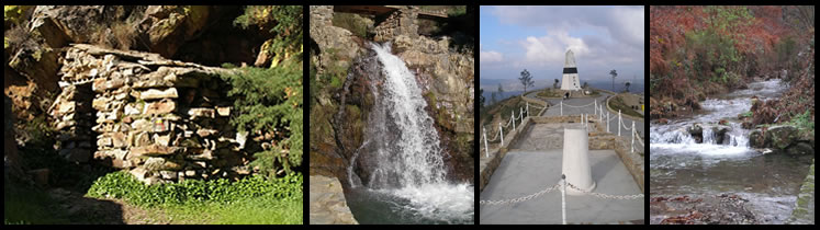
Oleiros
O concelho de Oleiros está situado numa zona
montanhosa marcada pela floresta e pelos rios, ribeiros e nascentes
de água, o concelho de Oleiros oferece sobretudo ao visitante a
beleza paisagística do seu património natural.
Trata-se de uma zona que conserva intactas muitas das suas
características e raízes rurais, como se pode apreciar em Álvaro,
uma das «aldeias de xisto», que mantém essa ligação ancestral entre
a natureza e a identidade cultural da população.
A abundância de ribeiras que atravessam o concelho favorece a pesca
desportiva, enquanto diversos percursos pedestres convidam o
visitante a explorar os locais de interesse paisagístico e os
pontos panorâmicos, nomeadamente nas margens do rio Zêzere, na
Serra do Muradal ou na maravilhosa zona de cascatas de Fraga de
Água d'Alta.
O concelho dispõe, igualmente, de um interessante conjunto de
capelas e igrejas espalhadas pelas diferentes povoações, com
destaque para a Igreja Matriz (séculos XVI-XVIII, com belos
azulejos e talha dourada), a Igreja da Misericórdia (século XVI) e
a Capela de Nossa Senhora Mãe dos Homens (século XVIII), na vila de
Oleiros.
À mesa, predominam os sabores rurais através de especialidades como
o conhecido cabrito estonado de Oleiros (assado com pele, como o
leitão), as trutas grelhadas, o coelho panado ou a sopa de
castanha, para além de doces tradicionais como o bolo de mel ou as
filhós e de uma apreciada aguardente de medronho local.
|
Oleiros
The municipality of Oleiros is located at a
mountainous zone full of forests, rivers, streams and natural
springs, the main tourist asset of the county of Oleiros is
precisely the beauty of its natural patrimony.
This unspoilt region preserves intact many of its rural
characteristics and roots, as may be seen at Álvaro, one of the
«schist villages», where the timeless relation between the
population's cultural identity and nature may still be
appreciated.
The abundance of streams that cross the county favour fishing,
whereas several walks and trails invite visitors to explore the
most scenic spots and viewpoints, namely at the banks of the River
Zêzere, the Muradal mountains or the wonderful waterfalls at Água
d'Alta (high water).
The county also boasts of a series of interesting chapels and
churches, such as the Mother Church (16th-18th centuries,
displaying beautiful tiles and gilded woodwork), the Miserichord
Church (16th century) and the Chapel of Our Lady Mother of Men
(18th century), at the small town of Oleiros.
At table, rural flavours predominate and the region boasts of
specialities such as the famous cabrito estonado of
Oleiros (roasted with crisp crackling), grilled trout, breaded
rabbit or chestnut soup, besides traditional desserts such as honey
cake and filhós (a kind of puff pastry) and
medronho, a popular local firewater.
|
|
|
|
Sertã
O concelho da Sertã apresenta, para além da
paisagem com rios, ribeiras e albufeiras que se desenham por entre
uma enorme mancha verde, um património histórico e cultural de
interesse que inclui desde calçadas e pontes romanas a castelos
medievais e ricas igrejas.
O nome de Sertã tem origem na curiosa Lenda da Celina, a mulher de
um nobre lusitano que, cheia de raiva pela morte do marido na luta
contra os romanos, teria avançado com uma sertã (frigideira) cheia
de azeite a ferver contra os inimigos, prestes a entrar no castelo,
forçando-os a recuar.
Na sede do concelho, vale a pena admirar a Igreja Matriz (século
XV), em estilo gótico e com ricas talhas douradas e azulejos dos
séculos XVI e XVII, a vizinha Capela da Misericórdia (séculos
XVI-XVII), e o belo pelourinho, do século XVI, em forma uma
pirâmide quadrangular com a Cruz de Malta, a esfera armilar e o
brasão da vila.
A segunda maior vila do concelho, Cernache de Bonjardim, possui
também uma bonita Igreja Matriz dos séculos XVI e XVII onde se
destacam os azulejos setecentistas.
As várias barragens no concelho da Sertã, como a de Castelo de
Bode, da Bouçã e do Cabril, oferecem belas paisagens e a
possibilidade de praticar desportos náuticos, e a imensa extensão
de matos e pinhais proporciona a oportunidade de passeios
tranquilos.
Em quase toda a região, fabricam-se boas aguardentes de frutos
locais, como cerejas, ameixas, pêssegos e medronhos. Na doçaria
destacam-se os cartuchos de Cernache do Bonjardim.
|
Sertã
The county of Sertã presents, besides the views
with the rivers, streams and dams which are designed between the
extensive green areas, an historical and cultural patrimony of the
most interest like Portuguese stone walks, roman bridges, medieval
castles and rich churches.
The name "Sertã" has its origins over the curious legend of Celina,
the wife of a Lusitanian noble man that, filled with hunger because
of the death of her husband in the fight against the Romans, would
have challenged the enemies that were about to enter the castle
with a "sertã" (another Portuguese word for frying pan) filled with
hot olive oil, forcing them to retreat.
It is worth the visit to the main church (15th century), gothic
style with fine gilded woodwork and tiles from the 16th and 17th
centuries, and also its neighbour - the Misericórdia Chapel - from
the 16th and 17th centuries. You can also notice the marker
(pelourinho) from the 16th century, with quadrangular pyramidal
shape with the carved Malta's Cross, the armillary sphere and the
village's symbol.
The second largest village of the county, Cernache de Bonjardim,
also has a beautiful church from the XVI and XVII centuries where
some XVII tiles can be found.
The several dams in the county, like Castelo de Bode, Bouça and
Cabril, offer beautiful landscapes and the possibility to practice
water sports, and the huge woods give the visitor an opportunity to
do some nice and relaxing walking.
Everywhere in the region they make an excellent fruit firewater
with cherries and plums, peaches and "medronhos". Sweet flavours
with Cernache do Bonjardim Cartuchos (see picture).
|
|
|
|
Vila de Rei
O concelho de Vila de Rei está coberto de extensos
pinhais fica situado precisamente no meio de Portugal,
geográficamente falando, como indica o Picoto da Melriça, um dos
seus monumentos mais interessantes: a torre, construída a uma
altitude de 600 metros, marca o centro geodésico do país e
proporciona uma fantástica vista panorâmica sobre um horizonte
vastíssimo. Se o tempo estiver claro, sem nevoeiro, é possível ver
a Serra da Estrela que está a 100 km de distância.
No mesmo espaço físico também podem visitar o pequeno Museu da
Geodésia.
Outra curiosidade natural do concelho de Vila de Rei é o conhecido
Penedo Furado, actualmente adaptado para acolher dois miradouros,
com um carreiro sobre uma plataforma rochosa rodeada de árvores e
pequenas quedas de água; a beleza do local atrai muitos visitantes,
pelo que conta com diversas infra-estruturas turísticas.
Na sede do concelho, vale a pena visitar a Igreja Paroquial, do
século XVIII, e a Capela da Misericórdia.
Outro local de grande interesse é o Castro de São Miguel, situado
no cimo da Serra da Ladeira, a cerca de 493 metros de altitude: o
recinto fortificado é considerado um Castro Celta da Idade do Ferro
e foi classificado como Monumento Nacional.
A gastronomia de Vila de Rei, abundante e saborosa, apresenta
especialidades como a sopa de peixe, o bucho recheado ou o cabrito
assado, além de doces típicos como o arroz doce e as broas de
mel.
|
Vila de
Rei
The municipality of Vila de Rei is covered by
large pine areas and it's located precisely in the middle of
Portugal, geographically speaking. This fact is marked by the peak
of Melriça, one of the many interesting monuments: The tower, built
on high ground (600 meters) is actually on the exact Geodesic
Centre of Portugal. From up there you can enjoy a fantastic
panoramic view over a very wide horizon. If the weather is clear
and sunny you can see as far as Serra da Estrela Hill’s 100km
away.
On the same area you can also visit the small Museum of
Geodésia.
Another curious thing in Vila de Rei is the well known Penedo
Furado. Lately there were built 2 belvedere's, with an actual
access through the rocky platforms giving the opportunity for a
wonderful stroll, with nature all over and delicious waterfalls;
the beauty of it sure deserves a visit. It's for sure a must see,
and it also has some tourist support near.
You can also visit the Parish Church, 18th century, and the
Misericórdia Chapel.
Another spot with interest is Castro de São Miguel, on top of the
Hill of Ladeira, 493 high. It's a fortified enclosure considered a
Celtic Castro from the Iron Age. It was classified as a National
Monument.
The gastronomy in Vila de Rei, abundant and delicious, presents
specialities like the fish soup, stuffed "bucho" or the roast lamb,
and also the typical sweets like sweet rice and "broas" of
honey.
|
|
|
|
Geocache
Vila de Rei, mais precisamente o Centro Geodésico de Portugal, foi
também o local seleccionado para a colocação desta geocache
"Lusitani: Pinhal Interior Sul".
Sendo o centro do país é, sem dúvida, de assinalar num projecto
desta natureza, que tenciona percorrer, ou fazer percorrer, o país
de lés-a-lés.
A geocache está à espera de visitas com os dados necessários para
levar a cabo esta aventura por Portugal.
Dentro do contentor vais encontrar um cartão especial (não o leves)
que terá inscrito um número. Anota este número e o nome da
geocache. Deverás guardar todos os 30 códigos parciais por forma a,
no final, conseguires obter as coordenadas para a última cache da
série Lusitani.
Resta-nos congratular a GeoDuplaP&F pela iniciativa deste projecto
Lusitani e agradecer ao MAntunes por amavelmente "doar" a
localização da cache anteriormente ocupada pela geocache "Centro Geodesico de Portugal [Vila de
Rei]" que já estava lá desde finais de 2002! Obrigado
Manel!
|
Geocache
Vila de Rei, more precisely the Geodesic Center of Portugal, was
also the choosen location for the new home of this geocache
"Lusitani: Pinhal Interior Sul".
Being the precise center of the country it is, unquestionably, a
must mark spot of a project like this one, that intent to travel
across the entire country.
This geocache is now waiting your visits with data needed to
complete this adventure through Portugal.
Inside the geocache container you'll find a special sheet (leave it
there) with a number. Please note this number and the geocache
name. You should keep all 30 partial geocaches codes together to
get the way to find the final coordinates for the last Lusitani
series geocache.
We must congratulate GeoDuplaP&F for the idea and the initiative
of this project - Lusitani - and thank MAntunes for kindly "donate"
the cache spot previously occupied by the geocache "Centro Geodesico de Portugal [Vila de Rei]" that
was there since late 2002! Thank you Manel!
|
| |
|
Aqui podes encontrar a lista
completa das geocaches da série
Lusitani com respectivo link para os sites
Here you can find the complete list of
the Lusitani series geocache with link to the
webpages
|
|
|
|
|
|
|
|
|
|
|
|
|
|
|
|
|
 Lusitani: Açores
by jorgebig
(Arquipélago dos Açores) Lusitani: Açores
by jorgebig
(Arquipélago dos Açores) |
Size:
 Difficulty: Difficulty:  Terrain: Terrain: |
|
|
|
|
|
|
Ainda não foram publicadas todas as geocaches da
série. Farei o update da lista à medida que forem sendo publicadas
até que a lista esteja completa.
|
Not all geocaches from the Lusitani series have
been published yet. I'll update this list as they are published and
until the list is complete.
|
| |
|
Ainda estão curiosos acerca do Pinhal Interior
Sul, é? Então aqui têm mais uns links para facilitar a pesquisa
sobre a região. Seguindo o link de cada um dos brasões serão
levados às páginas das camâras municipais correspondentes onde
encontraram muita e diversa informação.
Divirtam-se!
|
Still curious about Pinhal
Interior Sul, han? Well, there you go! Some usefull links to follow
and learn some more about the region. Following the links by
clicking each image below you'll be directed to the town hall
oficial webpage of each municipality, and you'll find loads of
information.
Have fun!
|
|
|
|
~ Lusitani:
Pinhal Interior Sul ~
|