|
Naturschutzgebiet "Bockhorner Moor"
Das 322 ha große Schutzgebiet bewahrt einen vergleichsweise kleinen Teil des ehemals riesigen Hochmoores, das weite Teile der ostfriesischen Geest bedeckte. Das Arteninventar  an hochmoortypischen Pflanzen und Tieren konnte sich hier zu relativ großen Teilen erhalten. an hochmoortypischen Pflanzen und Tieren konnte sich hier zu relativ großen Teilen erhalten.
Das Bockhorner Moor entstand in der Nacheiszeit auf nährstoffarmen, nassen Sandböden. Voraussetzung für die Entstehung waren hohe, gleichmäßig über das Jahr verteilte Niederschläge und eine geringe Verdunstungsrate.
Unter diesen schwierigen Bedingungen konnten nur Spezialisten überleben, wie z. B. die wurzellosen Torfmoose, aus denen das Hochmoor hauptsächlich gebildet wurde . Sie können wie ein Schwamm sehr viel Wasser aufnehmen und festhalten. An der Oberfläche wachsen sie langsam aber beständig weiter, während die unteren Teile aus Luft- und Lichtmangel absterben und schließlich den Torf bilden. Ihr unaufhörliches Wachstum führt über Jahre zu den für das Hochmoor charakteristischen, uhrglasförmigen Wölbung.
Das Bockhorner Moor
wurde erst in den letzten Jahren von den Menschen in Besitz genommen und genutzt. Als Torfstich oder Torfstechen wird der obertägige Abbau von Torf bezeichnet. Dieses organische Material, das durch beginnende Inkohlung entsteht, diente einerseits als niederenergetischer Brennstoff (wenn z.B. in flachen Regionen das Brennholz fehlt) und andererseits zur Verbesserung (Durchlüftung) des Bodens. Durch den oberflächlichen und bäuerlichen Torfstich veränderten sich die Lebensbedingungen im Ökosystem Moor dramatisch.
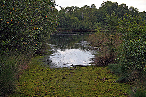
Heute ist es ein verheidetes Hochmoor mit unterschiedlich stark verbuschten Pfeifengras-Degenerationsstadien und Birkenmoorwaldresten, aber auch die typischen Bult-Schlenken-Gesellschaften sind noch vorhanden. In den Torfstichkuhlen hat teilweise wieder ein Hochmoorwachstum eingesetzt. Dieses Moor ist ein Zeugnis der Vergangenheit und bietet Lebensraum für viele typische Pflanzen und Tiere.
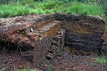
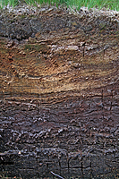
 Wachsende Moore können in zwei Schichten unterteilt werden. Das „Akrotelm“ (griech.: akros = höchst; telma = Sumpf) ist der obere Bereich und umfasst die Vegetationsschicht und den Moorboden. Dort entstehen durch Wachstum und Absterben von Pflanzenteilen die frischen organischen Substanzen (Torfbildungshorizont). Das „Katotelm“ (griech.: kato = unten) ist der darunter liegende wassergesättigte Bereich mit geringerer biologischer Aktivität. Diese Schicht wird aufgrund der geringen noch ablaufenden bodenbildenden Prozesse zum geologischen Untergrund gezählt und als Torferhaltungshorizont bezeichnet. In Regenmooren wird die oberste Torfschicht Weißtorf genannt, da sie aus weitgehend unzersetzten hellbraunen Torfmoosen besteht. Bei der unteren Torfschicht handelt es sich um Schwarztorf, der schon gut humifiziert ist und eine schwarz-braune Färbung mit noch erkennbaren Pflanzenresten aufweist. Wachsende Moore können in zwei Schichten unterteilt werden. Das „Akrotelm“ (griech.: akros = höchst; telma = Sumpf) ist der obere Bereich und umfasst die Vegetationsschicht und den Moorboden. Dort entstehen durch Wachstum und Absterben von Pflanzenteilen die frischen organischen Substanzen (Torfbildungshorizont). Das „Katotelm“ (griech.: kato = unten) ist der darunter liegende wassergesättigte Bereich mit geringerer biologischer Aktivität. Diese Schicht wird aufgrund der geringen noch ablaufenden bodenbildenden Prozesse zum geologischen Untergrund gezählt und als Torferhaltungshorizont bezeichnet. In Regenmooren wird die oberste Torfschicht Weißtorf genannt, da sie aus weitgehend unzersetzten hellbraunen Torfmoosen besteht. Bei der unteren Torfschicht handelt es sich um Schwarztorf, der schon gut humifiziert ist und eine schwarz-braune Färbung mit noch erkennbaren Pflanzenresten aufweist.
Der Earthcache “Bockhorner Moor”
An der angegebenen Koordinate findest Du eine kleine Torfstichkuhle, in der diese Schichten gut zu sehen sind. Am besten kommst Du über den Großen Querdamm dorthin. Die Kuhle darf frei besichtigt werden. Ab und zu finden hier auch spezielle Moorführungen statt. Sei aber bitte vorsichtig und bleibe auf den Wegen. Das Moor ist sehr trittempfindlich und kann schnell Schaden nehmen.
Logbedingungen
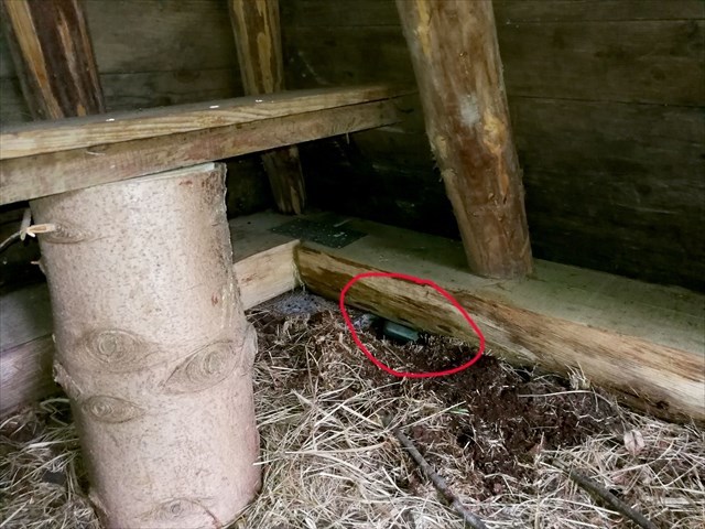
Um diesen Cache loggen zu dürfen müssen einige Bedingungen erfüllt werden. Dafür brauchst Du ein wenig Köpfchen, ein Zentimetermaß, ph-Teststreifen und/oder eine Suchmaschine im Internet. Köpfchen mußt Du selber mitbringen. Maßband und Teststreifen habe ich in einer kleinen Dose in der gegenüber liegenden Moorhütte deponiert (siehe Bild).
Frage
Wie alt ist das “Bockhorner Moor”?
Das Maßband
Messe die maximale Dicke der Weißtorf-Schicht! Wieviel Zentimeter sind es ungefähr?
Das Moor hat einen bestimmten Säuregrad
Bestimme den ph-Wert mit Hilfe der Teststreifen. Falls sich keine Pfütze in der Kuhle befindet, kann man den Teststreifen auch für einige Minuten ins feuchte Moor drücken. Bitte vorsichtig sein, damit der Platz nicht leidet. Und bitte, bitte nur einen Teststreifen verwenden! Wenn es nicht klappt, finde den ph-Wert auf andere Weise heraus!
Das Foto (KEINE LOGBEDINGUNG!)
Wenn Du magst, mache ein Foto von Dir und/oder Deinem GPSr, entweder bei der Arbeit und/oder einfach so vor der Torfstichkuhle oder in der Moorhütte.
Die Antwort auf die Frage und die Ergebnisse Deiner Messungen sende bitte an bockhorner-moor at tomizak.de. Das Foto füge bitte deinem Log bei geocaching.com bei. !
***** ENGLISH *****
Nature reserve "Bockhorner Moor"
The 322-ha-protective area preserves a relatively small part of the formerly gigantic high-level moor, the wide parts of the East  Frisian geest covered. The kind inventory in high-level moor typical plants and animals could keep here too relatively to large parts. Frisian geest covered. The kind inventory in high-level moor typical plants and animals could keep here too relatively to large parts.
The Bockhorner Moor originated in the postice age on wet sandy soil poor in nutrient. A condition for the origin were high, steadily about the year distributed precipitation and a low vaporisation rate.
Under these conditions only specialists can survive, e.g., the rootless peat bogs from which a high-level moor is primarily formed. They can absorb and hold like a sponge a lot of water. In the surface they grow slowly but steadily, while the lower parts from want of air and light lack die and form finally the peat. Their unceasing growth leads for years to the watch glass-shaped curvature typical for the high-level moor.
The Bockhorner Moor
 was taken only during the last years by the people in possession and was used. The super day dismantling of peat is called patch of peat or peat jump-off. This organic material which originates from beginning coalification served on the one hand as a down energetic fuel (if, e.g., in level regions the firewood is absent) and, on the other hand, for the improvement (aerating) of the ground. By the superficial and rural patch of peat the living conditions changed in the ecological system moor dramatically. was taken only during the last years by the people in possession and was used. The super day dismantling of peat is called patch of peat or peat jump-off. This organic material which originates from beginning coalification served on the one hand as a down energetic fuel (if, e.g., in level regions the firewood is absent) and, on the other hand, for the improvement (aerating) of the ground. By the superficial and rural patch of peat the living conditions changed in the ecological system moor dramatically.
Today it is a high-level moor, overgrown with heath and differently strongly scrubby whistle grass degeneration stadia and birch moor wood leftovers, but also the typical Bult-Schlenken societies still exist. In the peat-cutting hollows a high moor growth has started partially again. This moor is a testimony of the past and offers living space for many typical plants and animals.
 Growing moors can be divided into two layers. The "Akrotelm" (Greek ones: akros = highly; telma = marsh) is the upper area and encloses the vegetation layer and the marshy ground. There the fresh organic matters (peat education horizon) originate from growth and decease of plant parts. The "Katotelm" (Greek ones: kato = below) is the lying underneath water-saturated area with lower biological activity. This layer is counted on account of the low still running off ground-pedagogic processes to the geologic subsoil and when peat preservation horizon is called. In rain moors the uppermost peat layer white peat is called, because it exists of widely undecomposed tan peat mosses. With the lower peat layer it concerns black peat which is quite well humifiziert and shows a black-brown colouring with still recognizable plant leftovers. In the given coordinate you find a small patch of peat hollow in which these layers are to be seen good. Growing moors can be divided into two layers. The "Akrotelm" (Greek ones: akros = highly; telma = marsh) is the upper area and encloses the vegetation layer and the marshy ground. There the fresh organic matters (peat education horizon) originate from growth and decease of plant parts. The "Katotelm" (Greek ones: kato = below) is the lying underneath water-saturated area with lower biological activity. This layer is counted on account of the low still running off ground-pedagogic processes to the geologic subsoil and when peat preservation horizon is called. In rain moors the uppermost peat layer white peat is called, because it exists of widely undecomposed tan peat mosses. With the lower peat layer it concerns black peat which is quite well humifiziert and shows a black-brown colouring with still recognizable plant leftovers. In the given coordinate you find a small patch of peat hollow in which these layers are to be seen good.
The Earthcache “Bockhorner Moor”
In the given co-ordinate you find a small patch of peat hollow in which these layers are to be seen good. Best of all you come over the ”Großer Querdamm” dam there. The hollow may be freely visited. Now and again special moor guidances also take place here. Be careful, please and remain on the ways. The moor is very sensitive to step and can take fast damage.
Log terms
 To be allowed to log this Cache, some conditions must be fulfilled. For it you need a little brains, a tape measure, ph-test stripe and/or the Internet. You yourself must bring brains and maybe a camera. I have deposited dimension tape and test stripe in a small tin in the subtending moor hut (see picture). To be allowed to log this Cache, some conditions must be fulfilled. For it you need a little brains, a tape measure, ph-test stripe and/or the Internet. You yourself must bring brains and maybe a camera. I have deposited dimension tape and test stripe in a small tin in the subtending moor hut (see picture).
Question
How old is the “Bockhorner Moor”?
TheMeasuring tape
Measure the maximum thickness of the white peat layer! How many centimetres are approximate it?
The moor has a certain acid degree
Determining the ph value with the help of the test stripes. If no puddle is in the hollow, you can press the test stripe also for some minutes in the humid moor. Be careful, please, so that the place does not suffer. Please, please use only one stripe! If this does not go, finds out the ph value in other manner!
The photo (NO LOG-CONDITION!)
If you want, make a photo of you and/or your GPSr, either at work and/or simply thus before the patch of peat hollow or in the moor hut.
The answer to the question and the results of your measurements sends in bockhorner-moor at tomizak.de, please. The photo adds at your log on geocaching.com, please. !
|