Skip to content

Costa Vicentina - Projecto Alentejo [VN Milfontes] Traditional Geocache

Difficulty:
1.5 out of 5
Terrain:
2 out of 5

Size: Size:   small (small)

Join now to view geocache location details. It's free!

Watch

How Geocaching Works

Please note Use of geocaching.com services is subject to the terms and conditions in our disclaimer.

Geocache Description:


Planícies sem fim queimadas pelo sol impõem um ritmo lento e compassado. É o nosso Alentejo.

  No Norte Alentejano, as serras começam a dar lugar às planícies. Andando para Sul, o interior mostra-nos as searas douradas ondulando ao vento, onde ao longe se deixam avistar algumas serras. Chegados ao litoral, somos deslumbrados por praias agrestes de uma beleza selvagem, lagoas verdejantes e rios que correm para a liberdade.

 O passado está sempre presente no Alentejo, desde a pré-história, passando pelo Império Romano, pela ocupação Árabe e pelos Castelos Medievais, os vestígios do passado são incontornáveis para o visitante, oferecendo uma verdadeira viagem no tempo.

 Mas, nem só do espírito vive o viajante, e quando o apetite se faz sentir, o Alentejo tem muito para oferecer. Neste capítulo a criatividade dos Alentejanos não tem limite. Umas entradas com um extraordinário queijo de Serpa ou de Nisa ou presunto de Barrancos acompanhado com um pão de Mértola, siga pela Sopa de Cação ou pelo Gaspacho, isto sem falar na Açorda Alentejana nem num peixe fresco grelhado acabado de pescar nas arribas rochosas da Costa Vicentina, continue com o Ensopado de Borrego ou com as Migas de Espargos com carne de porco, momento certo para provar um tinto de Borba, Redondo, Reguengos ou Vidigueira. Para terminar, os doces conventuais, que tal uma Sericaia, umas Trouxas-de-ovos ou um Toucinho Rançoso.

 Se gosta de passear pela natureza, passeie a pé pelo verde das Serras d’ Ossa, Portel ou Grândola. Visite o Parque Natural da Serra de S. Mamede onde as paisagens do Sul encontram as do Norte e descubra o mais Alto Alentejo. No litoral, faça uma viagem inesquecível entre os golfinhos do estuário do Sado ou delicie-se com a quietude das praias quase desertas do Sudoeste.

 O Alentejo tem muito para oferecer e espera a vossa visita.
Endless and sun burned plains set a slow and  steady rhythm. It's our Alentejo.

  In the Northern Alentejo, the mountains are replaced by plains. As further as you head South you'll see the golden corn fields waving on the wind and at distance some shy mountains. As soon as we reach the shore we're amazed by wild and beautiful beaches, green lagoons and rivers that flow for the ocean's freedom.

 The past is something that is always present in Alentejo. From the Roman Empire, the Muslim occupation and the Medieval Castles, the past remains are something impossible to avoid by the visitors, to whom is offered a real time travel.

 But, not only of the spirit the travellers can live, and when the appetite makes it feel, the Alentejo has a lot to offer. In that chapter Alentejo people's creativity knows no limit. As starter an extraordinary cheese from Serpa or Nisa or even a piece of ham from Barrancos with some bread from Mértola. After that, a squalus soup or a cold tomato soup, this without speaking in the Alentejo Bread-Soup or a grilled fish just caught at the rocky cliffs of Vicentine Coast. After that continue with a Ham ragout or some bread soup with asparagus with pork meat, right moment to taste some Borba, Redondo, Reguengos or Vidigueira red wine. To finish, the conventual deserts. What about a "Sericaia", some "Trouxas-de-ovos" or a "Toucinho Rançoso".

 If you like to walk trough the Nature, take a walk by Ossa, Portel or Grândola mountains ranges. Visit the S. Mamede Natural Park where the South landscape meet the Northern and discover the highest Alentejo. Close to the shore make an unforgettable travel with the dolphins in the Sado's estuary or delight yourself with the Northwest almost deserted beaches.

The Alentejo has a lot to offer and waits for your visit.


O PROJECTO ALENTEJO

  Este projecto, nasceu da conjugação dos esforços de vários geocachers Alentejanos que resolveram divulgar o “seu” Alentejo. O projecto ALENTEJO, consta de uma série de caches temáticas espalhadas pela maior região do país e de uma cache mistério final a que só será possível aceder depois de visitar as outras. Aproveite estas caches, não só para descobrir os temas referidos, mas também para conhecer melhor o Alentejo.


THE PROJECT ALENTEJO

  This Project was born with the joined efforts of some Geocachers from Alentejo that decided to divulge "their" Alentejo. The Project ALENTEJO, is formed by a group of themed geocaches hidden all over the countries' larger region and a final geocache that you'll only be able to find after visiting all the others. Use this caches, not only to know more about the themes but also to know better the Alentejo.


Religião
Pré-História
Fortificações
Cortiça
Água
Paisagem
GC1EBXK - Os Romanos
GC1ECGC - O Porco
GC1EBXQ - O Arroz
GC1E172 - Costa Vicentina
GC1E170 - A Indústria
GC1E171 - A Energia
Azeite
Cante
Frescos
Islamismo
Vinho
Pão
GC1EY9B - São Barão - Final

Sudoeste Alentejano e Costa Vicentina

O Parque Natural do Sudoeste Alentejano e Costa Vicentina abrange o litoral sudoeste de Portugal Continental, no sul do litoral alentejano e no barlavento algarvio em redor do Cabo de São Vicente. Inclui territórios de freguesias dos seguintes concelhos:

  • Sines (freguesias de Porto Covo e Sines);
  • Odemira (freguesias de Longueira / Almograve, Santa Maria, São Luís, São Salvador, São Teotónio, Vila Nova de Milfontes e Zambujeira do Mar);
  • Aljezur (freguesias de Aljezur, Bordeira, Odeceixe e Rogil);
  • Vila do Bispo (freguesias de Budens, Raposeira, Sagres e Vila do Bispo).

Para além da faixa costeira e da zona submarina de 2 km a partir da costa, o parque inclui o vale do rio Mira desde a foz até à vila de Odemira.

Na área do parque encontram-se diversos 
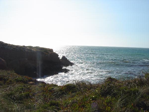
tipos de paisagens e habitats naturais e semi-naturais, tais como arribas e falésias abruptas e recortadas, praias, várias ilhotas e recifes (incluindo a ilha do Pessegueiro e um invulgar recife de coral na Carrapateira), o estuário do Mira, o cabo Sardão, o promontório de Sagres e Cabo de São Vicente, sistemas dunares, charnecas, sapais, estepes salgadas, lagoas temporárias, barrancos (vales encaixados com densa cobertura vegetal), etc. As altitudes máximas são: 324 m, no interior (em São Domingos, Odemira); e 156 m, no litoral (em Torre de Aspa, Vila do Bispo). A profundidade máxima é 32 m, 2 km ao largo do Pontal da Carrapateira (Aljezur).

Southwest Alentejo and Vicentine Coast Natural Park

This natural park has spectacular views over the seashore with cliffs hiding wonderful sandy beaches and estuaries.

The Southwest Alentejo and Vicentine Coast Natural Park covers the coastline in the municipalities of Sines, Odemira, Aljezur and Vila do Bispo.

This is an area of outstanding natural beauty, important for its landscape, geology, flora and fauna, architecture, history, traditional and archaeological heritage.
Some of its most impressive features are the reefs and small islands such as Pessegueiro and Carrapateira together with the Mira estuary, Cape Sardao and the Sagres promontory. The rocks of Arrifana and Odeceixe and the soil area at Sagres contrast with the sand dunes in Vila Nova de Milfontes and Sardao.

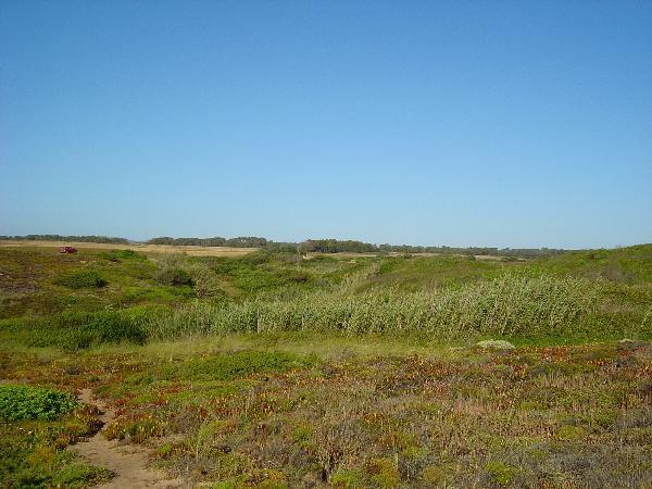
The vegetation varies depending on the soil and the wind and salt exposure. There are many well preserved areas in the sand dunes and some areas of cork and Medronheiro trees. The vegetation is abundant around Sagres – Sao Vicente and Carrapateira.

On the cliffs it is common to find the great cormorant and storks which are often observed building their nests in rocks by the sea. There are also a few otters and amphibians such as toads and frogs. The coastline in this area is a very important migration corridor particularly for birds of prey and sea birds.

There are many historical remains of the presence of Phoenicians, Arabs and Romans as well as more recent defensive constructions.

A  CACHE

Esta cache foi colocada para possibilitar um passeio. Podem deixar o carro a cerca de 1300 metros, no estacionamento da praia e seguir pelas arribas até à cache ou deixá-lo a 200 metros e andar um pouco a pé, há para todos os gostos.

Atenção redobrada às crianças e ao oceano. No último troço há que passar por uma "praia" onde, no caso de maré alta a rebentação pode surpreender os mais desatentos. Não arrisquem a vossa segurança.

O acesso recomendado é pelo acesso à Praia das Furnas. Se tentarem outro acesso mais a Sul estão por vossa conta nos areais...

Se não conseguir fazer o Found, quer seja por não encontrar a cache quer seja por não a poder procurar, terá que cumprir estes requisitos para ser autorizado a fazer o log na cache final do Projecto Alentejo:

- terá que registar o Not Found, notes não valem.
-terá que provar que esteve mesmo lá. Uma fotografia sua junto das arribas servirá.

THE  CACHE

This cache was placed to allow you a little walk. You can leave the car 1300 meters away, in the beach parking and follow the cliffs to the cache, or you can drive up to 200 meters and walk a bit, it's your choice.

Doble your attention to the children and the ocean. In the last track, you'll have to pass by a "beach" where, in High tide the waves can catch you. Don't risk your safety.

The recomended access is trhough the access named Praia das Furnas. If you try another one to the South, you're on your own in the sand...

If you cannot make the Found, no matter it's because you can't find it or you cannot look for it, you'll have to fill this requirements be authorized to log the found in the final cache of the ALentejo Project:

- You'll have to register your Not Found, notes aren't allowed.
-you'll have to prove that you've been there. A picture of you close to the cliffs will do.

Additional Hints (Decrypt)

[Pt] Qronvkb qr hz neohfgb, n 3 zgf qb gevyub [Eng]Haqre n ohfu, 3 zgf sebz gur cngu

Decryption Key

A|B|C|D|E|F|G|H|I|J|K|L|M
-------------------------
N|O|P|Q|R|S|T|U|V|W|X|Y|Z

(letter above equals below, and vice versa)