Pasterze Glacier EarthCache
-
Difficulty:
-

-
Terrain:
-

Size:  (not chosen)
Please note Use of geocaching.com services is subject to the terms and conditions
in our disclaimer.
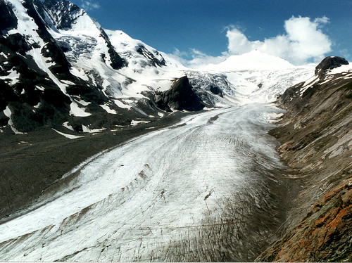
Pasterze is the longest glacier in Austria and in the Eastern Alps,
at approximately 9 km in length, reaching from 3,463 m to 2,100 m
above sea level. It lies in the Hohe Tauern mountain range directly
beneath Austria's highest mountain, the Großglockner.
Glaciers: A glacier is a permanent body of ice, consisting largely
of recrystallized snow, that shows evidence of downslope or outward
movement due to the pull of gravity. Except for a thin surface
layer that is chilled below freezing each winter, the ice
throughout many glaciers is at the pressure melting point, the
temperature at which ice can melt at a particular pressure. Under
these conditions melt water and ice can exist together in
equilibrium. In these glaciers, which are found mainly in low and
middle latitudes, ice is at the pressure melting point throughout.
Glaciers can only form at or above the snowline. The snowline is a
line that marks the intersection of the land with an irregular
surface representing the lower limit of perennial snow. Glacier ice
is essentially a metamorphic rock that consists of interlocking
crystals of the mineral ice that has been deformed by flow owing to
the weight of overlying snow and ice. Newly fallen snow is very
porous, having a density less than a tenth that of water. Air
easily penetrates the pore spaces where the delicate points of
snowflakes gradually disappear through evaporation. The resulting
water vapor then condenses, mainly in constricted places near the
centers of ice crystals. In this way, snowflakes gradually become
smaller, rounder and thicker and the pore spaces between them
disappear. Snow that survives a year or more and achieves a density
that is transitional between snow and glacier ice is called firn.
Ultimately, firn passes into true glacier ice when it becomes so
dense that it is no longer permeable to air. Although now a rock,
such ice has a far lower melting point than any other naturally
occurring rock, and its density of about 0.9 g/cm3 means that it
will float in water. Source: The Dynamic Earth an introduction to
physical geology, Brian J. Skinner, Stephen C. Porter, Published by
John Wiley and Sons, Inc, 1989
Pasterze Glacier with it´s 10km lenght, a surface of area cca 20km2
and a depth of XXX m, the Pasterze glacier is by far the longest
glacier in Eastern Alps. It´s name origiates from a slavic word
"Pastir" (shepherd or small pasture). Perhaps this demonstrates
that there is a grain of truth in the legend of the bold
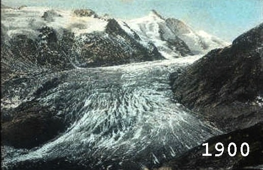
inhabitants of the pastures in the area. Around the middle of the
last century the glacier moved toward the area the area of
Freiwandeck and was about YYY meters larger. The Pasterze glacier
may be reached by cable car (but it is not necessary). A safe path
makes it possible to reach the icy slopes. A number of altimetric
signs indicate, that the Paterze has retreated over the past few
decades. In 1963 the masess of ice still reached the station of
cable car bellow. Here another attraction of the Glocknerr massif
begins, the educational trail along the glacier, which permits one
to reach the Glockner refuge (Glockner house) in an hours
walk.
For the succesfull log, pls, send me an answer of the next
questions:
1. What is XXX ?
2. What is YYY ?
3. What is the name and altitude of the Peak
on the left side of glacier (view from down to the top)
?
4. What is the altitude difference of the level of the glacier in
the years:
*1960-1970
*1970-1990
*1990-2005
*1960-29.6.2008 (N47.04.465, E012.44.681)
5. The coordinates of 29.6.2008 are the coordiates of the "end" of
glacier. Pls, send me upload the picture of this place to your log.
BUT MOST IMPORTANT CONDITION FOR LOG - SEND
THE DISTANCE BETWEEN THE END OF THE GLACIER (DAY OF YOUR VISIT) AND
COORDINATES OF 29.6.2008
6. Pls, send the picture of the point of the earthcache
coordinates.
7. How do you call snow with density transitional between snow and
glacier and one or more years old?
ATTENTIONWALKING ON THE GLACIER ON YOUR OWN
RISK

Additional Hints
(No hints available.)