[CZ]
Vítejte na
Tocníku
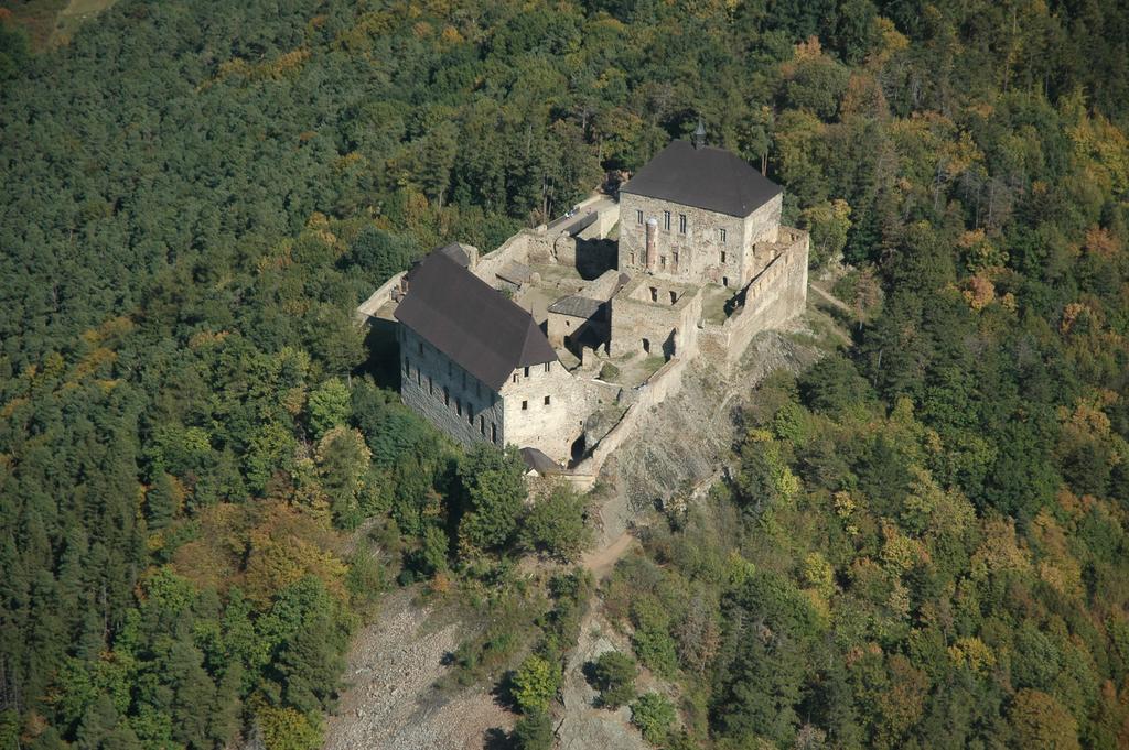
foto použito se souhlasem www.akpm.cz
Hrad Tocník je postaven na úzém
hrbetu, vystupujícím nad okolní krajinu.
Vrcholová cást hrbetu, zvaná
Zámecký vrch, je tvorena tvrdými horninami,
které se usadily na dne úzké morské
pánve pocátkem starších prvohor
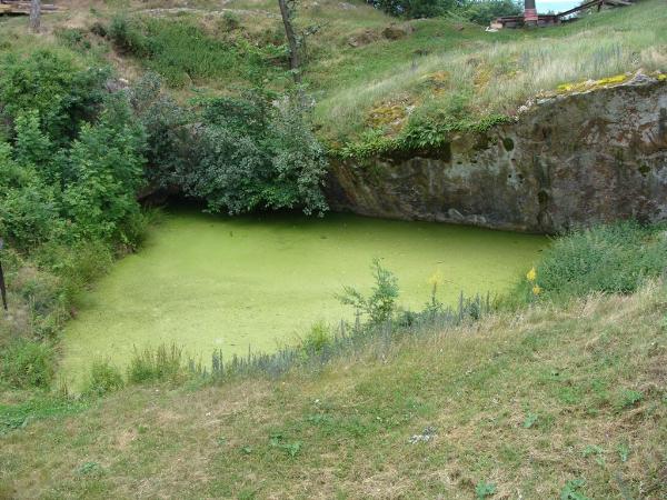
(ordoviku) pred 490 miliony let. V jižní stene
stredoveké vodní nádrže je dobre
patrná hranice mezi dvema geologickými útvary.
Vystupují zde na povrch mladší vrstvy
ordovických hornin, které spocívají na
starších vrstvách starohorních
(proterozoických) hornin. Styk horninových vrstev
ilustruje zajímavé geologické jevy -
hiát, transgresi a úhlovou diskordanci. Po
usazení proterozoických hornin na dne more
došlo k jejich vyzdvižení a
zvrásnení (zprohýbání vrstev
vlivem geologických tlaku). Na dobu více než 60
milionu let se tyto horniny ocitly na souši, kde
podléhaly procesum rozrušování, odnosu
méne odolných vrstev a ohlazování.
Takovému prerušení sedimentace se
ríká odborne hiát. Pocátkem ordoviku
celá oblast poklesla a byla znovu zaplavena morem.
Znovuzaplavení pevniny morem se nazývá
transgrese. V dusledku prerušení sedimentace
(hiátu) a zprohýbání vrstev
proterozoika byly mladší ordovické vrstvy
vzhledem ke starším vrstvám
proterozoickým uloženy pod jiným úhlem.
Tento jev se jmenuje úhlová (také
zjevná) diskordance.
Podmínky
uznání logu:
- odešlete fotografii:
- vás s úhlovou diskordancí;
- hradu Tocník.
- a emailem pres profil mi pošlete odpoved na tyto
otázky:
- odhadnete délku a úhel odhalené
úhlové diskordance;
- vyjmenujte cásti Prvohor (paleozoikum).
[EN]
Welcome to castle
Tocník
The castle Tocník is situated on a narrow ridge
called Zámecký vrch Hill which is much higher that
the surrounding area. On the topic of the ridge called
Zámecký vrch Hill are exposed thin beds of resistant
rocks (greywackes and cherts), deposit on the bottom of a narrow
sedimentary basin at the beginning of the Ordovician, 490 Ma ago.
The boundary between older Precambrian and younger Ordovician
sedimentary rocks is well exposed near the eastern gate of the
castle (now used as entrance). It forms the southern wall of the
medieval water-reservoir. Hiatus, transgression and angular
disconformity are instructively exposed at this outcrop. Rocks
sedimented on the botton of Procambrian ocean have been uplifted
and folded. They were positioned about the see level for more than
60 Ma and they weathered and were denudated. Such break of
sedimentation is called hiatus. Only neat the beginning of the
Ordovician the whole area declined and was gradually overflow by
sea. Such overflow by sea is called transgression. The strike of
the bedding of both Precambrian and Ordovician are different from
each other and mark the hiatus and folding mentioned above. Such
phenomenon is called angular disconformity.
For the valid "cache found"
log:
- you have to upload a photo of:
- yourself with water well and angular unconformity;
- castle Tocník.
- and send me via profile e-mail answers to these
questions:
- estimate length angle of debunked angular uncorfomity;
- enumerate parts of Primary (paleozoikum).

www.geocaching.cz