The Volcanic Region of La Garrotxa Natural Park is situated in the northeast of Catalonia. Within the Park there are 26 nature reserves (980 ha) wich preserve, for the most part, the volcanic cones of greatest geomorphologic interest. The Natural Park is the best preserved volcanic zone on the Iberian Peninsula, and one of the most representative of continental Europe.
Although the volcanoes of La Garrotxa are relatively recent (from the Quaternary period) it is necessary to go back milions of years to understand their origins. After the alpine orogeny, which resulted in the formation of the Pyrenees and which caused folds in the sedimentary eocenic material in the region, there was a distensive tectonic period, leading to the fragmenting of the earth’s crust into a series of parallel fault lines that separated different blocks of the substrata, raising some and lowering others with respect each other. This structure should be wiewed in Western Europe within the context of the so-called intracontinental rift system, responsible for the formation of the Eifel volcanic region in Germany, the Auvergne volcanic region in France and the La Garrotxa volcanic region.
The intense fracturing of the earth’s crust made it possible for magma generated in the upper mantle to rise directly to the surface. The distribution of the volcanic cones in the area is directly related to the positions of these fractures; volcanoes usually appear over the points of intersection between two faults or over the crack itself.
There was volcanic activity in this area over hundreds of thousands of years, with volcanic eruptions separated by long dormant periods. The last eruption took place 11.500 years ago. The superficial alteration of the volcanic materials has resulted in the existence of over 3.300 hectares of unique volcanic soils.
Almost all of the volcanoes in La Garrotxa originated from a single eruption, which may have lasted from a few days to a few weeks. In general, however, each eruption consisted of different phases, during which the type of eruptive activity would change.
The magma did not come from a magma chamber, but instead rose directly to the surface. This means each volcano being formed in a single eruptive episode and was incapable of further activity.
The most frequent explosive activity is Strombolian in nature, characterised by the expulsion of ash, lapilli, slag and volcanic bombs. All of these materials accumulate around the chimney and result in the formation of the volcanic cone.
Another type of much more explosive activity is phreatomagmatic activity, caused by the interaction of magma, wich reaches temperatures of over 1000 ºC, and underground water. When large amount of water vapour form, the increase in the pressure from this results in large explosions. The results of this are extensive, circular depressions in the earth.
Over 20 lava flows also form a valuable part on the area’s geological heritage. The lava flows emitted by the volcanoes cooled in the shape of the slope, occupied the course of rivers, and filled in valleys, turning them into very fertile plains. The emission of lava flows is the result of effusive activity taking place when the magma escaped at low pressure. The different types of flowing and cooling have resulted in the strange forms of the basalt crags in the area, wich are cracked into columns, blocks or slabs depending on whether cooling occurred when the lava was stationary or in motion.
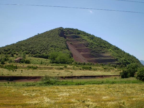
The majority of the volcanoes were formed in two eruptive phases: the first was Strombolian, during which the volcanic cone was formed with the deposit of the materials, and the second was effusive, with the emission of lava flows. The results of these are volcanic cones with hollowed, arc-shaped craters resulting from the later erosion of one side by the lava flow (El Croscat Volcano).

Volca del Croscat Nature Reserve: The clay pits area of the Croscat Volcano were restored in 1995 with the aim of putting the deteriorated area back in order, minimising the impact on the landscape, preventing erosion and guaranteeing public access for educational purposes.
...............
How to log this cache?
This is an EarthCache so you won't find any items, box, physical cache or logbook at this site. To log this cache just answer at least two simple questions and email these answers to us! You can find the answers at the info board in the entrance.
.Heigth in meters of the volcanic cone of El Croscat?
.Name of the exceptional forest growing on the lava flow from the El Croscat volcano?
.What award did the restoration of the clay pits win?
E-mail this answers and make a picture of yourself sitting on the stone bench at the centre of the volcano with your GPSr (see photo).
After I validate by mail your answers, you will then have to "log you find it" with a picture of another location in the natural park you like the most. It also would be nice if you mentioned your nationality in your log.
Note: Logs with incorrect pictures or logs from teams emailing incorrect answers will be removed without further notice!