
Desde la Plaza del Emperador Carlos V hasta la Glorieta de
Fernández Ladreda baja este paseo que supone el gran canalizador
del tránsito rodado que procedente del centro de la capital se
dirige hacia Andalucía y Toledo. El nombre le viene de la esposa de
san Isidro Labrador, patrón de Madrid. Se llamó realmente María
Toribia, nacida, se supone, en Uceda y muerta hacia el 1180 y
posteriormente canonizada santa por Inocencio XII
 va trazado ya en el plano de A. Espinosa de los Monteros
(1769).
Por
primera vez se numeraron dichas manzanas y los portales. Se puso
una baldosa en cada una de ellas, de las que aún se conservan
numerosas que se pueden ver paseando por Madrid. Era un
procedimiento para poder inventariar y catalogar los inmuebles y
facilitar el despliegue del
Catastro.
En la zona sólo había entonces huertas, caminos rurales, alguna
casa aislada y varias posadas, ya que es atravesada por los caminos
que llevaban hacia el sur y este de la península.
va trazado ya en el plano de A. Espinosa de los Monteros
(1769).
Por
primera vez se numeraron dichas manzanas y los portales. Se puso
una baldosa en cada una de ellas, de las que aún se conservan
numerosas que se pueden ver paseando por Madrid. Era un
procedimiento para poder inventariar y catalogar los inmuebles y
facilitar el despliegue del
Catastro.
En la zona sólo había entonces huertas, caminos rurales, alguna
casa aislada y varias posadas, ya que es atravesada por los caminos
que llevaban hacia el sur y este de la península.
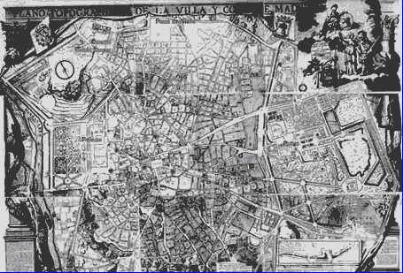
Detalle del plano de A.
Espinosa/Detail of A. Espinosa plane
Por tanto es la arteria que
articula, desde el punto de vista residencial, el tridente de
Carlos III, el cual estaba formado por el
Paseo de las Delicias, el
Paseo de Santa María de la Cabeza y
la Ronda de Atocha. Se trata del
acceso a la trama urbana por la puerta de Atocha. Su esquema seguía
la configuración del tridente barroco, conocido como "patte d'oie",
una fórmula que había servido para remodelar el urbanismo romano
desde el siglo XVII y que, con gran éxito, estructuró los jardines
europeos del siglo XVIII desde que André Le Nôtre diseñara
Versalles, un modelo que se llevaría a los jardines de Aranjuez. En
la cartografía madrileña realizada durante el reinado de Carlos III
este eje se manifiesta como una zona organizada, pero periférica y
semirural, una zona popular destinada al paseo que regularizaba el
espacio existente entre la ciudad y las riberas del Manzanares.
Pero la intención al crear estos espacios no era urbanizar la zona,
sino el embellecimiento de los accesos a la ciudad y proporcionar
un espacio para el esparcimiento de la población, de ahí el nombre
de paseos. El plano de 1785 de Tomás López, refleja a la
perfección la intersección de estos dos grandes triángulos.
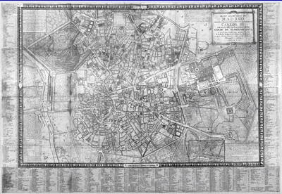
Detalle del plano de Tomás
López/
Detail of
Tomas Lopez plane
El crecimiento de la ciudad y el avance tecnológico, con la
llegada del ferrocarril, como atestigua la construcción de la
estación de Atocha, Delicias y Peñuelas, hizo que aquel
paraje semirural se convirtiera en la zona de expansión y ensanche
por excelencia. En 1857 el arquitecto e ingeniero Carlos María de
Castro recibió el encargo de realizar un estudio de proyecto de
ensanche de la capital y dos años más tarde presentaba el
Anteproyecto de Ensanche de Madrid,
propuesta que se aprobaría mediante Real Decreto de 19 de junio de
1860. El plan ideado por Castro yuxtaponía a la ciudad histórica
una amplia superficie envolvente desde el noroeste al sureste todo
ello ordenado a través de una retícula ortogonal de manzanas
rectangulares. El arquitecto planteaba un ensanche que conservaba
en su zona sur el tridente proyectado durante el reinado de Carlos
III, una serie de paseos que respetaban las grandes plantaciones de
árboles existentes desde casi un siglo antes en un intento de hacer
perdurar el paisaje dieciochesco. Los nombres de las calles son
testimonios claros del antiguo carácter paisajista de la zona:
Chopera, Acacias, Olmos, Delicias etc.
En esta vía, así como en la del Paseo de las Delicias, además de
las estructuras industriales, tomaría una gran importancia en la
malla urbana la arquitectura doméstica. En torno a estas dos
grandes calles se desarrollarán una serie de tipologías de
viviendas que, partiendo de un modelo de construcción destinada a
las necesidades de casas obreras, dará paso a unos edificios que
ganan en altura y prestancia, dirigidos a una clientela burguesa.
Son de alguna manera grandes telones que conforman
arquitectónicamente las vías principales (Santa María de la Cabeza
y Delicias). De forma paralela a estas construcciones, se
desarrollan en las calles de segundo y tercer orden un tipo de
construcción más económica y de menor altura.
En todas ellas predomina el empleo de la estructura metálica y
del ladrillo, utilizado éste último tanto en el sistema estructural
como en lo decorativo, conformando el modelo de "Neomudéjar
madrileño". Es también característica la utilización de aleros de
madera soportados por canecillos. Muchos de estos edificios son
proyectados tanto por modestos maestros de obras, como por
renombrados arquitectos o ingenieros, como es el caso de Alberto de
Palacio o Eugenio Jiménez Corera, con los que se va enriqueciendo
esta arquitectura doméstica. Son un buen ejemplo de estos modelos
modestos las viviendas realizadas para D. Francisco González, las
Casas de Moret y el Parador de Picazo, sitas en Paseo de Santa
María de la Cabeza, nº 2, 4 y 6, realizadas por el maestro de obras
Narciso de Pascual García entre 1908 y 1909.
Continuando por el paseo desembocamos en la
antigua sede de la fábrica de lámparas
OSRAM, uno de los más interesantes ejemplos madrileños de
arquitectura destinada a la industria. El responsable fue de nuevo
Alberto de Palacio, el arquitecto de la estación de Atocha, con la
colaboración del ingeniero Francisco Borrás, quien había patentado
un nuevo sistema de cubierta en hormigón con una gran amplitud de
luces de forjado, dando lugar a grandes crujías. Este sistema,
conocido como "hormigón armado sistema Borrás" se aplicó por
primera vez en esta fábrica. La gran novedad de esta obra es el
renovado planteamiento estético, alejado de la arquitectura
industrial tradicional en ladrillo y próxima a los modelos foráneos
centroeuropeos.
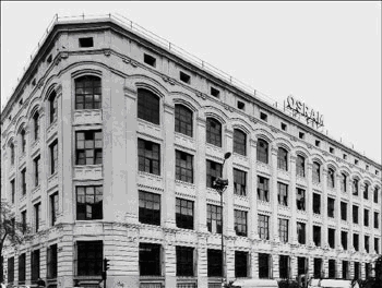
Foto de la fábrica de Osram en
1956 / Photo of Osram's factory in 1956
Desde 1991 está incoado expediente como Bien de Interés Cultural
(BIC) y desde el 2001 se adaptó para dependencias municipales del
Instituto de la Vivienda con la renovación llevada a cabo por
Guillermo Costa Pérez-Herrero, alterando la entrada principal como
era en origen. Frente a esta dependencia municipal se localiza otro
más de los mercados populares que se
instalaron en este barrio del ensanche. En las cercanías de este
mercado se localizaba antiguamente la ermita dedicada a Santa María
de la Cabeza, realizada en 1721 y siendo muy popular una
romería el 9 de Septiembre.
El caché es una caja pequeña, magnética, que se encuentra en la
barandilla del puente que cruza la antigua M-30 y el río
Manzanares; desde aquí tendrás unas vistas del río, eso sí, ahora
mismo da pena verlo después de la faraónica obra de soterramiento
de la vía de circunvalación, aunque esperemos a que acaben las
obras de acondicionamiento y ajardinamiento de las orillas para que
se convierta toda la zona en un bonito paseo al lado del cauce.
Igualmente podrás ver las instalaciones del Invernadero, la Casa
del Reloj y el Matadero de Arganzuela, así como el Puente de la
Princesa. En el otro sentido, verás el Puente de Toledo y el
estadio Vicente Calderón. Llevad lápiz o bolígrafo y no hay espacio
para intercambiar. Tened cuidado ya que es una zona muy transitada
de geomuggles, pero sobre todo de coches.
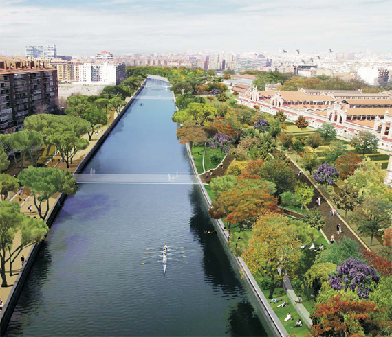
Así debería haber quedado tras las obras / Thus it
should have been after the public work
* * *
This avenue go from Emperor
Carlos V Square to Fernandez Ladreda's Square; it supposes the
great road link of the traffic rolled that proceeding from the
center of the capital goes towards Andalucia and Toledo. The name
is come of the wife of San Isidro Labrador, patron saint of Madrid.
She was called really Maria Toribia, born in Uceda and she died
about 1180 and she was canonized holy for Inocencio XII later. It
is drawn already in the plane A. Espinosa de los Monteros (1769).
These apples and portals were numbered for the
first time. It put on a tile in
each of them, of whom yet there remain numerous that you can be
seen while you are walking along Madrid.
It was a procedure to be able to inventory and
to catalogue the buildings and to facilitate the unfolding of
Cadastre. In the zone only there were vegetable gardens, rural
ways, some isolated house and several inns; already that are
crossed by the ways that took towards the south and east of the
peninsula.
Therefore it is the artery
that articulates, from the residential viewpoint, the trident of
Carlos III, which was formed by the Walk of the Delicias, the Walk
of Santa Maria de la Cabeza and Atocha's
Round.His
scheme was following the configuration of the baroque trident,
known like " patte d'oie ", a formula that had served to remodel
the Roman urbanism from the 17th century; with great success that
it constructed the European gardens of the 18th century since André
Le Nôtre was designing Versailles, a model who would remove to
Aranjuez's gardens. In the cartography of Madrid realized during
the reign of Carlos III this arterial road demonstrates as an
organized, but it was peripheral and semirural zone. It was a
popular zone that it was destined for the walk that was
regularizing the existing space between the city and the banks of
the Manzanares River. But the intention
to create these spaces it was not to urbanize the zone, but the
embellishment from the accesses to the city and to provide a space
for the relaxation of the population, of there the name of
paseos. The plane of Tomás Lopez (1785) reflects to the
perfection the intersection of these two big
triangles.
*
*
*
The
growth of the city and the technological advance caused that
semirural place became the zone of urban expansion area by
excellence with the arrival of railroad (it testifies the
construction of the station of Atocha, Delicias and Peñuelas). In
1857 the architect and engineer Carlos Maria of Castro received the
order to make a project study of widening of the city; two years
later he was presenting the Preliminary design of Widening of
Madrid, offer that would be approved by means of Royal decree of
June 19, 1860. The plan designed by Castro was juxtaposing to the
historical city a wide surrounding surface from the northwest to
the south-east, all this arranged across an orthogonal reticle of
rectangular apples.
The architect was raising a
widening that was preserving in the south zone the trident
projected during the reign of Carlos III, He had designed a series
of walks that were respecting the big plantations of existing trees
from almost one century before in an attempt of making last the
landscape of the 18th century. The names of the streets are
testimonies of the old character of landscape painter of the zone:
poplar grove, acacias, elms, delights etc.
In this
street, thus like in the Paseo de las Delicias, besides to the
industrial structures, the domestic architecture would take a great
importance in the urban mesh. Around these two big streets, they
will develop a series of types of housings that, departing from a
model of construction destined for the needs of working houses,
step will give to a few buildings that win in height and
excellence, directed a bourgeois clientele. Of form parallel to
these constructions, they develop in the streets of the second and
third order a type of more economic construction and of minor
height. In all of them there predominates the employment of the
metallic structure and of the brick, used both in the structural
system and in the decorative thing, constituted the model of
"Neomudéjar of Madrid ". The use of wood eaves supported by gutters
is also characteristic. Many of these buildings are projected so
much by modest construction foremen, like by famous architects or
engineers, as it is the case of Alberto of Palace or Eugene Jiménez
Corera. They are a good example of these modest models the housings
realized for D. Francisco Gonzalez, Moret's Houses and Picazo's
Inn, situated in Paseo Santa Maria de la Cabeza, n º 2, 4 and 6
realized by the master builder Narciso de Pascual García between
1908 and 1909.
Continuing for the walk, we
come to the old factory of lamps OSRAM, one of the most interesting
examples of Madrid of architecture destined for the industry. The
architect was again Alberto de Palacio (the designer of Atocha's
station) with the collaboration of the engineer Francisco Borras,
who had patented a new system of cover in concrete with a great
extent of lights of forged, giving place to big you were
squeaking.
This system, known as
"reinforced concrete Borras system" it was applied by the first
time in this factory. The great innovation of this work, it was the
renewed aesthetic exposition, removed from the industrial
traditional architecture in brick and next the foreign Central
European models. It is initiate process as Asset of Cultural
Interest (BIC) from 1991 and it was adapted for municipal
dependences of the Institute of the Housing from 2001
with the renovation carried out by Guillermo Costa
Perez, altering the principal
entry.Opposite
to this municipal dependence, it is located of the popular markets
that they installed in this neighborhood of the widening. Near of
this market there was located the old hermitage dedicated to
Saint Santa Maria de la Cabeza, realized in 1721 and there was a
popular pilgrimage on September 9.
The
cache is a small and magnetic box, which is in the rail of the
bridge that crosses the old road M-30 and the river Manzanares;
here you will see a few sights of the river, it yes, just now makes
sad to see it after the pharaonic work of the ring
road; let's hope that they end the works of conditioning and
areas of beautiful parks and gardens of the shores in order that
the whole zone turns into a nice walk next to the riverbed. Equally
you will be able to see the installations of the Greenhouse, the
House of the Clock and Arganzuela's Slaughter house, as well as the
Bridge of the Princess. In another side, you will see
the Bridge of Toledo and the stadium Vicente Calderón. You will
have to bring pencil or pen and there is no space to exchange. Be
careful since it is a zone very travelled of geomuggles, but
especially of cars.