GRAND RIVER GAGING STATION (Portland) -
EARTHCACHE
 Purpose
This earthcache is designed to show the how today’s rivers are
monitored/regulated. The above coordinates above will take you to a
USGS gage station. USGS is the United States Geological Survey.
These gauging stations are used for water resources, specifically
the Grand River in this case. The station here is continuously
measuring the depth and the amount of flow of the river.
It is very important to monitor, and control the river’s flow for
several reasons. We can start with the control of flooding or at
least the warning of flooding. An important reason for this gauging
and regulating of the river is to limit erosion of the river banks.
Though erosion will always take place it can be held to a minimal.
Ground water also depends on these regulated flows. Ground waters
include some small lakes, marshes and wetlands.
A gaging station is a facility used by
hydrologists and others to monitor streams, rivers, lakes, canals,
reservoirs, and other bodies of water. Gaging stations typically
collect information such as water height and discharge (flow). The
collected information is recorded by a site visit or is transmitted
via telephone or a satellite communication system to the stations
owner.
Logging
Requirements
To log this cache you will need to complete the following.
- Post a picture of yourself/team with your GPSr and the gage
house in the background
- E-mail the flow rates at the time of your visit, and for the
corresponding week prior -
Real
time data for this gage station
- E-mail the water lever the river was at the time of your visit,
and for the corresponding week prior. -
Real
time data for this gage station
- Also look at the flow rate and water level data for the
Grand River Gaging Station in Grand Rapids for the same time
period you visited THIS Gaging Station.
- In your e-mail, provide a brief explanation of the differences
in the water flow rate and depth during the week for THIS Gaging
Station.
- Also provide a brief explanation of what contributes to
differences in the water flow rate for the two gage stations for
the DAY you visited this gaging station.
- Be sure to include the time you were there
- If prior week data is not available due to equipment
malfunction, use data for the day when equipment was functioning
properly again.
-
Each Cacher that logs a find is required to submit answers to the
questions
above***
(failure to comply will result in a deletion of your
log).
- The purpose of Earthcaches is for everyone to learn from their
visit/experience
- Combined photos are acceptable, but each cacher must be
identified.
All that should be posted with your log will be a photo.
The answers should be e-mailed to us (via our
profile) and not posted in your log.
Go ahead and log your find at the same time you're sending your
email answers.
***
= the only exception to this are young kids that are caching with
their parents (who have their own account, but not computer
privileges).
Grand River Gaging Station (Portland)
The Grand River Gaging Station (Portland) is operated by the USGS
(United States Geological Survey). This gaging station records
water height, discharge and transmits its data back to the USGS
headquarters in real time by
telephone.
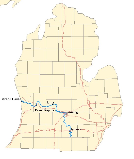
The Grand River is the longest river in the
U.S. state of Michigan. It runs 260 miles (420 km) through the
cities of Jackson, Lansing, Grand Rapids, and Grand Haven, and the
counties of Hillsdale, Jackson, Ingham, Eaton, Clinton, Ionia,
Kent, and Ottawa before emptying into Lake Michigan.
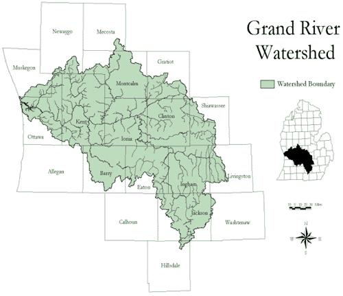
The Grand River watershed drains an area of 5,572 mile² (14,431
km²). The Grand River carries an average 3,800 ft³/s (108 m³/s).
It has several dams along its length but is a
trout and
salmon stream for
much of its length.
Much of the basin is flat and it contains many swamps and lakes.
Nevertheless, there is an elevation difference of 700 feet (213 m)
between the source and mouth of the river. Tributaries are the
Red Cedar River,
Looking
Glass River, Maple River, Flat River,
Thornapple
River, and the
Rogue
River. The Grand River Watershed is comprised of two parts, the
Upper Grand River watershed and the Lower Grand River Watershed.
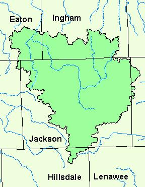
The Upper Grand River Watershed is a 572,376-acre watershed in
parts of Hillsdale, Jackson, Eaton, Washtenaw and Ingham Counties.
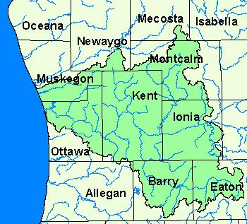
The Lower Grand River watershed is approximately 3,020 square miles
in parts of Newago, Montcalm, Muskegon, Kent, Ottawa, Ionia,
Barry and Eaton Counties. The waterrshed also includes the
Thornapple River, Flat River, and Rogue River Watersheds, which
flow into the Grand River, and enters Lake Michigan at Grand Haven.
This gaging station is located in the Lower Grand River
Watershed in Ionia County.
Here is an
interactive map of the
Grand
River Watershed (A watershed is an area of land that drains to
a common point)
The posted coordinates above will lead
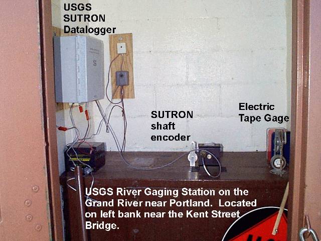
you to the gage "house". The original Gage House was a brick
structure holds the stream gaging equipment - typically a gage of
some type, a computer, and communications equipment. A stilling
well or a vertical pipe was located beneath the gage house. Water
enters the well through one or more inlet pipes. The water in the
well rises to the same level as the stream. Recording equipment in
the gage house recorded the water level in the well. Communications
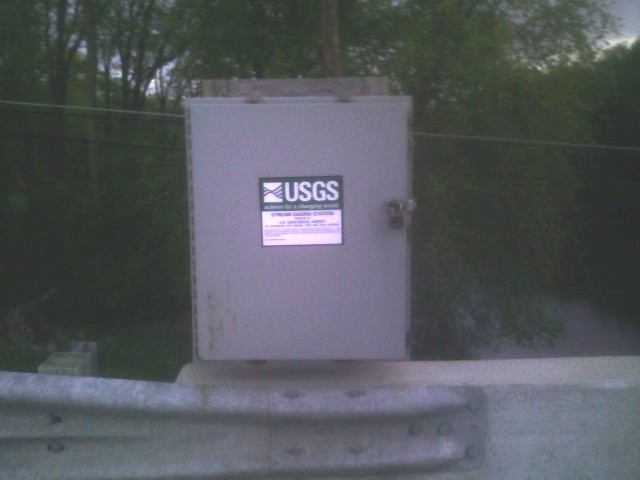
equipment transmits the data to the USGS. Due to recent
reconstruction of the Kent Street Bridge, a new Gage station has
been constructed, see photo below.
Parking is
available
approximately 300 feet
s
outh of the gaging station. There is a slight pullout on the right
shoulder.
Station operated in cooperation with
Consumers
Energy and the
City of
Portland
This station is managed by the LANSING
FIELD OFFICE
This is the
NEW gaging station for the Grand River at this
location. Reconstruction
of the bridge must have caused the change?
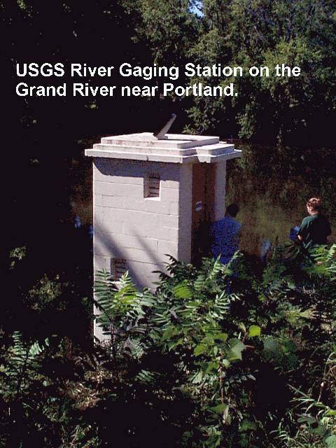
Here is a
historical picture of what used to be the Gage House
Here is a historical picture of the inside of the former Gage
House
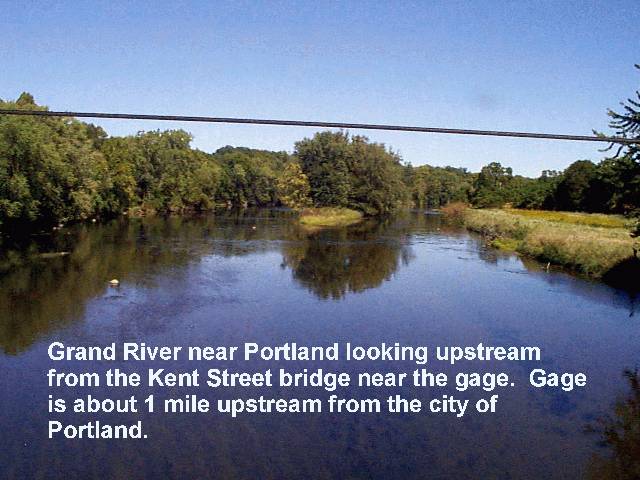
A picture looking upstream
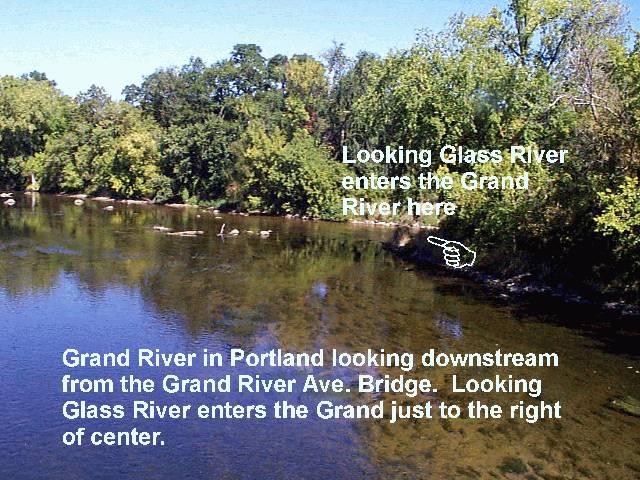
A picture of the confluence of the Grand River and Looking Glass
River
Gaging Station History
In the 1880's, John Wesley Powell, the second director of the USGS,
requested that stream flow be monitored in eight river basins in
the West. It was his idea to measure the flow of streams and rivers
and determine the viability of irrigation systems for this acrid
region. In 1889, the first U.S. stream gaging station was
established on the Rio Grande River in New Mexico. At this station,
standard stream flow measurement procedures were devised.
Today, the USGS operates and maintains more than 85% of the
nation's stream gaging stations. There are over 7,000 stream gaging
stations in the United States, Puerto Rico, and the U.S.
Territories of the Pacific Islands.
The USGS uses it's stream gaging network to provide a free
continuous source of well documented and archived water data. This
data is used by government agencies and private companies to
forecast flooding, design bridges, allocate drinking and irrigation
water, for recreational use, and to manage our valuable surface
water resources.
Real time data for this gage station may be found the internet at:
http://waterdata.usgs.gov/mi/nwis/uv/?site_no=04114000
Addtional
Stuff
Grand River (MI) RED JEEP Travel Bug -
click here to read the logs
The highest water level measurement was 12.98 ft on
04/21/1975
The lowest water level measurement was 3.8 ft on 10/10/1963
Grand River was called the Owashtanong River by the Ottawa,
Chippewa and Pattawatomi tribes which originally inhabited the
area, and was formed by the same Ice Age glaciers that created the
Great Lakes.
CONGRATULATIONS TO THE
BURCH CREWON BEING
FTF