The 1950s to the 1980s were the hey day of NASA’s space programs, and Australia played a large role with shared facilities to track and monitor satellites and space vehicles. Whilst Woomera was used in the 1950s, in the 1960s the centre of action moved to the ACT. Although Woomera was an excellent environment for picking up faint radio signals from space, it was too remote, and the ACT was selected because of its geological stability, low radio interference, and closeness to a regional support base. Several facilities were required, and the ACT provided ideal separation with its nicely divided valleys. Tidbinbilla was opened in 1965, Orroral Valley in 1966 and Honeysuckle Creek in 1967.
Whilst Tidbinbilla and Honeysuckle were used for deep space missions (missions to the moon, Mercury, Venus, Mars, Jupiter and Saturn), Orroral was used to support earth orbiting satellites, eventually including the Colombia Space Shuttle. Orroral was part of NASA’s Spacecraft Tracking and Data Acquisition Network, and was known as STADAN Station 21! Equipment at Orroral was able to track several satellites simultaneously, using Minitrack static antenna arrays, Baker Nunn cameras to photograph satellites in space, and a Laser ranging satellite tracker which measured the transit time of a pulse of light from the station to the satellite and back.
 Before
 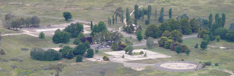 After
After
For more information, we recommend these sources - Pictorial History and Written History . Browse through to see how the site developed over the years, and how it looked compared to the remains we see now.
This multi takes you on a tour of the now disbanded facility. Visit each of the following coordinates to learn more about the facility and gather the numbers for GZ.
Now don’t bolt out here without bringing the details for other caches in this area. Make an outing of it, and bring the kids if you have them – these are all easy walks and interesting locations. Bring a picnic, or thermos and snack, and while you’re here you can do Moon Mirrors, Orroral Run, and The Valley 4 – Gurgling Cache. What a great opportunity for a caching day in the mountains.
W1. For how many hours per day did this facility operate? = A
W2. How many million metres of cables were at the station? = B
W3. How many metres across was the dish? = C How many bolts in each group? = D
W4. When facing the steps, how many concrete pads to the right? = E
W5. How many drainage holes in the terracotta coloured tiled area? = F How long were the shifts at the canteen? = G
W6. In kilometres, how far away was the transmitter? = H
W7. How many groups of antennae were there? = I
W8. How many buildings had sliding roofs to house cameras? = J
GZ = 35 deg 3(E+H+J).(D-I)(C+H-A)(E x B–I)
148 deg 5(G-F+J).(D-E-B) (G+I-F)(E+J)