BLUE CAVE
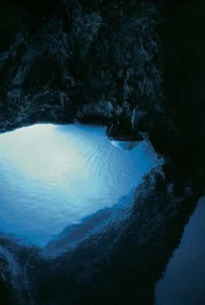
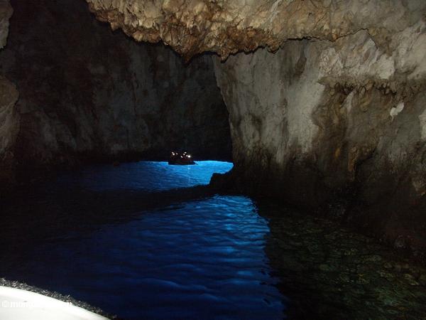
The Island Biševo is made up of limestone, which is riddled with caves. 26 sea caves are known along the coast of the island, which may all be visited by boat. But the most well known cave is Modra Špilja, the Blue Grotto. It is called Skuja na Zanje in the local dialect.This blue grotto has a natural entrance below the sea level. The only way to enter the cave was originally by diving. But more than a century ago an artificial adit was built to alow visitor to enter the cave by boat. Still a swim in the blue water seems to be an (optional) part of the cave visit.The location of the cave and the natural entrance make the time between 11 and 12 ideal for a visit. This is the time when the light inside the cave is best. The earlier or later during the day, the less light in the cave. Before and after the sun hits the sea in front of the cave, a visit is absolutely pointless.Another cave on Biševo is Medvidina Cave at the southern coast. From the big natural entrance at the beach, a 760m long dry passage leads into the cliff. It was once the habitat of the Mediterranean monk seal, a marine mammal which is now almost extinct.
Islands along the Blue Cave belong to the Dinarides, which form a mountain chain in southern Europe, spanning areas of Slovenia, Croatia, Bosnia and Herzegovina, Serbia, Monte Negro and Albania. During the Alpine earth movements that occurred 50-100 million years ago (mesozoic era), immense lateral pressures folded and overthrust the rocks in a great arc around the old rigid block of the north-east.
Thanks to a long-term tectonic descent of the Croatian coast, the partially submerged western Dinaric Alps form the numerous islands (Krk, Rab, Pag, Brac, Hvar...) and harbors. The western Dinarides have a character of a parallel chain of long islands, which are in fact ridges jutting out from the sea.
Island Bisevo and its neighbourhood is formed of tertiary sedimentary rocks of limestone, which were dissoluted into karst landscape. An activity of mildly acidic water acting on soluble bedrock resulted into a karst formation known as a cave. Over time these fractures enlarge as the bedrock continues to dissolve. Openings in the rock increase in size, and an underground drainagesystem begins to develop, allowing more water to pass through and accelerating the formation of underground karst features.
(The carbonic acid, that causes these features here, is formed as rain passes through the atmosphere picking up CO2, which dissolves in the water. Once the rain reaches the ground, it may pass through soil that may provide further CO2 to form a weak carbonic acid solution: H2O + CO2 -> H2CO3 .)
 For the valid "cache found" log:
You can upload a photo of you inside the cave. (not obligatory condition)
Additionaly send me via profile e-mail answers to these three questions:
1. What are exact coordinates of the cave´s entrace.
2. What is the length of the cave.
3. What is the water depth in the cave.
4. Send me both name and location of another cave which has been formed the same way as the Blue Cave.


MODRA ŠPILJA
Otok Biševo se sastoji od vapnenca, koji je protkan pećinama. 26 morskih špilja je poznato duž obale otoka, koje se sve mogu posjetiti brodicom. No, najpoznatija špilja je Modra špilja, Plavi groto. U lokalnom dijalektu se zove „Skuja na Zanje“. Ova plava špilja ima prirodni ulaz ispod razine mora. Jedini način za ulazak u špilju izvorno je bio roneći. No, prije više od stotinu godina izgrađen je umjetni prilaz, da omogući posjetiteljima ulazak u špilju brodom. Ipak, plivanje u plavoj vodi čini se da je (opcionalni) dio posjete špilji. Lokacija pećine i prirodni ulaz čini vrijeme između 11 i 12 idealno za posjete. Ovo je vrijeme kada je svjetlo u špilji najbolje. Ranije ili kasnije tijekom dana, manje je svjetla u pećini. Prije i nakon što sunce udari u more ispred pećine, posjet je apsolutno besmislen. Druga špilja na Biševu je Medvidina Špilja na južnoj obali. Od velikog prirodnog ulaza na plaži, 760m dugi suhi prolaz vodi u stijenu. To je nekada bilo stanište sredozemne medvjedice, morskog sisavca, koja je sada gotovo izumrla. Otoci duž Modre špilje pripadaju Dinaridima, koji čine planinski lanac u južnoj Europi, u rasponu područja Slovenije, Hrvatske, Bosne i Hercegovine, Srbije, Crne Gore i Albanije. Tijekom Alpskih zemljanih pokreta, koji su se dogodili prije 50-100 milijuna godina (mezozoik era), ogromni bočni pritisci presavili su i navlačili stijene u velikom luku oko starog krutog bloka na sjevero-istoku. Zahvaljujući dugogodišnjem tektonskom spuštanju hrvatske obale, djelomično potopljeni zapadni Dinaridi tvore brojne otoke (Krk, Rab, Pag, Brač, Hvar ...) i uvale. Zapadni Dinaridi imaju karakter paralelnog lanca dugih otoka, koji su u stvari grebeni koji strše iz mora. Otok Biševo i njegovo susjedstvo je formiran tercijarnim sedimentnim stijenama vapnenca, koji su otopljeni u krškom krajoliku. Djelovanje blago kisele vode, koja djeluje na topivim stijenama, rezultiralo je u krškom formiranju poznato kao špilja. Tijekom vremena te pukotine su se povećavale kao nastavak topljenja. Otvori u stijeni su se povećavali, i počeli su se razvijati podzemni odvodni sistemi, omogućujući da prođe više vode i ubrzava formiranje podzemnih krških značajki. (Ugljična kiselina, koja uzrokuje ove značajke ovdje, formira se dok kiša prolazi kroz atmosferu uzimajući CO2, koji se otapa u vodi. Nakon što kiša dosegne zemlju, ona može proći kroz tlo, koje može pružiti dodatni CO2, i formira se slaba otopina ugljične kiseline: H2O + CO2 -> H2CO3). Za važeći "pronalazak": Moguće uploadati sliku sebe unutar špilje. (neobavezan)
Dodatno, pošaljite mi putem profila na e-mail odgovore na ova tri pitanja:
1. Koje su točne koordinate ulaza u pećinu.
2. Kolika je duljina pećine.
3. Kolika je dubina vode u pećini.
4. Pošaljite mi i ime i mjesto druge špilje koja je formirana na isti način kao Modra špilja.