- Minnesota Geology
-
Lake Harriet - A Buried
River Valley
The continental glaciers spreading over
Minnesota during the Great Ice Ages brought vast quantities of rock
material from the North to be dumped indiscriminately during the
recession of the ice. Old river valleys were filled and belts of
hills were formed as conditions changed. The Lake Harriet landscape
has such an origin.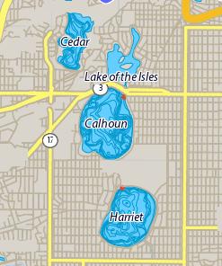
Leaving the present channel of the
Mississippi River at the Plymouth Avenue Bridge, a pre-glacial
valley runs almost directly south beneath Lake of the Isles, Lake
Calhoun, and Lake Harriet to the Minnesota River at Bloomington.
This valley was mostly filled but not completely obliterated by
glacial deposits. The unfilled portions of the valley are now
basins, which are filled by lakes perched high on glacial debris.
Located last in a chain of five lakes located in Uptown
Minneapolis, Lake Harriet lies directly over this ancient valley,
formed as an ice block depression during the most recent
glaciation. Its surface is in a setting of hills piled up while the
ice front paused here in its final retreat about 10,000 years
ago.
Lake Harriet has a surface area of 335
acres and is the second largest lake in Minneapolis. Its average
depth of twenty-nine feet (eighty-two feet maximum). Now located in
an urban residential area, the lake is fed largely by storm
drainage, runoff, direct precipitation, and groundwater seepage.
Throughout its history, Lake Harriet has undergone many changes,
driven by both natural and human influences.
TO LOG THIS
CACHE:
1) The former
valley’s rocky floor is how many feet below you?
2) Record the shoreline surface water
temperature.
E-mail me the answers
HERE.
Source:
- Display- Geological Society of Minnesota and the Board of Park
Commissioners 1955.
Links:
-
Minneapolis Park and Recreation Board