Wedgwood Erratic EarthCache
-
Difficulty:
-

-
Terrain:
-
Size:  (not chosen)
Please note Use of geocaching.com services is subject to the terms and conditions
in our disclaimer.
A long time ago, about 15,000 years ago, the Vashon glacier began
to melt and recede from the lands that were to become known as the
Puget Sound region and the Columbia Basin region. By 11,000 years
ago, the glacier has retreated to the border of present-day Canada.
During its advance, the glacier had carved out Lake Washington,
Lake Tapps, Lake Sammamish, Puget Sound, and Hood Canal. The other
major shaper of the land -- the pushing of the Pacific Plate
underneath the North American plate, and the docking of terranes
(fragments of continents) had already occurred long ago.
The Vashon glacier was the last "stade" (a glacial advance and
retreat) to cover the region. It was the last glacier of the
Pleistocene Epoch, which lasted from 2 million years b.p. (before
present) to about 10,000 years b.p. As far south as the Seattle
area to the west and the Spokane area to the east, the glacier, at
its thickest, reached 3,000 feet of ice. To give a comparison, the
Pacific Northwest's tallest skyscraper (as of 2003), Seattle's Bank
of American Tower (Columbia Tower), is about 997 feet tall.
When the glacier retreated for the last time it left behind this
big rock, known to geologists as the Wedgwood Erratic.
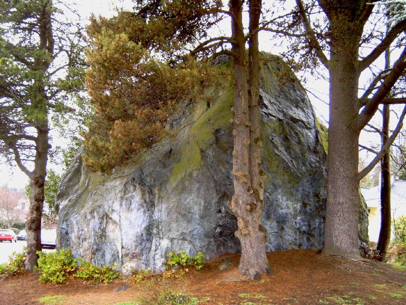
Native Americans knew what would become the Wedgwood neighborhood
because it was a crossroads. Over 14,000 years ago, the Vashon
Glacier left behind this large boulder. Geologists call the feature
an erratic since it is unlike any other rocks in the area. The rock
was useful landmark and it became the intersection of a number of
trails through the dense forest.
After the Native Americans departed for reservations, the rock
became a popular picnic site for Seattle residents. Professor
Edmund Meany of the University of Washington often led field trips
there. It was called simply, Big Rock. Mountaineers and Scouts
enjoyed climbing it.
Big Rock was owned by Winlock Miller, a regent at the University.
His father had acquired the land prior to statehood. In 1941, Big
Rock was in the middle of Al Balch's Wedgwood development. Balch
had to promise not to touch the rock as part of the agreement to
sell. After that, Big Rock became Wedgwood Rock. Neighbors cared
for the plants and trees that grew around it and continue to do so
to this day.
In 1970, Wedgwood Rock acquired a new reputation. Some neighbors
complained to the city council about hippies who frequented the
rock. Complainants reported that, "dirty, long-haired, bearded
individuals" (Lake City Star) loitered around the rock, climbed it,
and disturbed the neighborhood. Climbers were accused of harassing
citizens, taking drugs while on the rock, and using abusive
language. The petitioners expressed the belief that Big Rock was
being used by hippies to identify homes to burglarize. In October
1970, the city council took the situation seriously and passed an
ordinance making it a crime to climb Big Rock, punishable by a fine
of $100.
To log this cache, you must email us the answer to these two
questions: Please do not include the answers to the questions in
your on-line logs, either in the clear or encrypted.
1. How tall is the rock?
2. What’s the circumference of the rock?
And to prevent armchair logging, you must attach a picture
of you, yourself and/or your group to your FOUND IT log. Bonus
points if your group is large enough to encircle the rock.
Both parts are required, and you need not wait for a reply
from me before logging, but logs without the proper email and/or
pics will be deleted.
If you want to make this a two-fer check out grossi's virtual
Terracache.
Additional Hints
(No hints available.)