Le Fort de Figuerolles Traditional Geocache
-
Difficulty:
-

-
Terrain:
-

Size:  (regular)
Please note Use of geocaching.com services is subject to the terms and conditions
in our disclaimer.
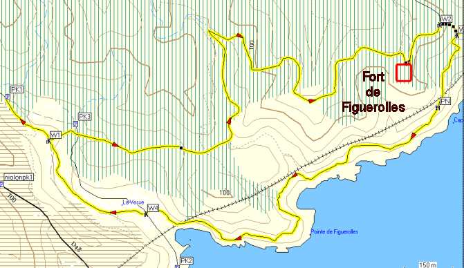
Circuit de 6 km dans les collines de l’Estaque proche de la
Vesse. visite des ruines du Fort et panorama sur la rade de
Marseille.
6 km circuit in the hills of l’Estaque
close to the Vesse, visit the ruins of fort and panorama over
Marseille. Return by the Customs trail with bathing when passing on
the beach.
Lorsque vous quittez la D48 le Rove - Niolon pour rejoindre la
Vesse, vous arrivez sur un parking sur lequel un panneau vous
informe que cette route est interdite aux voitures des non
résidents du 1er mai à fin aout. Personnellement, j’ai
toujours utilisé cette route sans problème.
Donc continuez vers l’un des 3 parkings, le PK1 étant le plus
pratique. Marchez sur la route jusqu’au point WP1 d’où
part un sentier sur la gauche. 100m plus loin vous arrivez sur un
pont qui franchit le vallon mais qui est fermé par une grille à
chaque extrémité. Vous pouvez le contourner par la gauche (nord)
pour descendre sur la route que vous traversez. Ensuite poursuivez
la balade vers le fort en suivant le schéma.
Après la visite du fort marchez sur un chemin vers WP2 et quittez
le pour emprunter un sentier qui descend vers la mer pour rejoindre
le sentier des douaniers en WP3. Ce sentier vous ramène au point
WP4 par le point PN pour piqueniquer, puis par la plage de
Figuerolles où vous pourrez vous rafraichir.
Je vous recommande un équipement de randonneur car certains
passages sont difficiles.
Le sentier de WP1 à WP3 n’est pas balisé et n’apparaît
pas clairement sur la carte IGN au 1/25000.
Bonne promenade!
La cache est une boite en plastic étanche contenant :
- Logbook et crayon.
– Chapeau provençal-magnet.
– Porte-clé Poker 100.
– Petite voiture.
– Bague fillette.
- Oakcoin.
- Travel slug « Pastis de Marseille ».
When you leave the D48 le Rove - Niolon to go
to « la Vesse », you arrive at a parking lot where a sign informs
you that this road is forbidden to cars of non-residents from 1 May
to the end of August. Personally, I have always used this road
without any problems.
So go to one of 3 carparks, PK1 being the most convenient. Walk on
the road to the point WP1 where begins a trail on the left. 100m
farther you get on a bridge that spans the valley but is closed by
a gate at each end. You can bypass it by the left (north) to
descend on the road that you cross.
Then continue your walk towards the fort in the diagram. After
visiting the fort walk on a path which you exit at WP2 to borrow a
path that leads down to the sea to reach the trail customs
WP3.
This trail takes you back to the point WP4 la Vesse by the PN for a
picnic, then by the beach Figuerolles where you can refresh.
I recommend equipment hiker because some passages are difficult.
The trail WP1 to WP3 is not marked and is not clear on the map IGN
1 / 25000.
Good walk!
The cache is a watertight plastic box containing:
-- Logbook and pencil.
-- Hat Provencal-magnet.
-- Porte key Poker 100.
– Small car.
-- Girl ring.
-- Oakcoin.
-- Travel slug "Pastis de Marseille."
Additional Hints
(No hints available.)