The cache is not at the listed coordinates. Solve the puzzle to
locate the cache.
Lenape Park consists of over 400 acres of wetlands, ponds,
rivers, creeks, meadows and forest. It comprises one of the largest
undeveloped properties in the Rahway River watershed.
Many of the most noticeable features of the park today are not
natural. For the most part, they were created by the Army Corps of
Engineers during a massive flood control project which began in the
late 1970's. Among other changes to the geography of the park, the
Army Corps re-routed the Nomahegan Brook, and partly filled the
pond along County Park Drive, directing its overflow through a
culvert under the entryway to the park from the Boulevard and into
the Rahway River. The blacktopped berms which now provide walking
paths toward Echo Lake Park in the west and Black Brook Park in the
east were constructed at the same time. Though these are used for
walking and bicycling, their primary purpose is flood control. The
Army Corps also constructed the large cement dam which crosses the
Rahway River just upstream of the Boulevard during this flood
control project.
Lining the banks of the Rahway River as it parallels the
"straightaway" section of trail to the east of the flood control
dam, are a number of large earthen mounds. They all have a
characteristic horseshoe shape, hollowed out in the middle, with
their entrances generally facing east. From local accounts, these
seem to date from the time of the First World War. They have been
explained as the remains of earthen bunkers in which ammunition and
explosives were kept. These products were being manufactured by a
factory adjacent to the park in Kenilworth and stored behind the
thick earthen walls of the mounds for safe keeping. 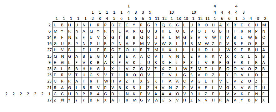 Hidden in the grid is a picture. You can unveil it by using the
numbers on the sides of the grid to determine which squares are
shaded and which are white. The numbers tell you how many shaded
squares there are in the corresponding row or column. For example,
2 4 5 tells you that there are 2 shaded squares together and then
at least one white square before the next block of 4 shaded squares
and then later a block of 5 shaded squares.
Hidden in the grid is a picture. You can unveil it by using the
numbers on the sides of the grid to determine which squares are
shaded and which are white. The numbers tell you how many shaded
squares there are in the corresponding row or column. For example,
2 4 5 tells you that there are 2 shaded squares together and then
at least one white square before the next block of 4 shaded squares
and then later a block of 5 shaded squares.
When you are finished, use a Caesar Shift on the remaining white
squares to reveal the location of the cache. You can use
RuffNekk's Crypto Pages for help with Caesar Shift
ciphers.
Keep the completed puzzle. You may need it
to solve the Life on the Edge puzzle.
You can check your answers for this puzzle on
Geochecker.com.