Le Bois Papineau
Un trésor écologique et géologique au cœur de Laval
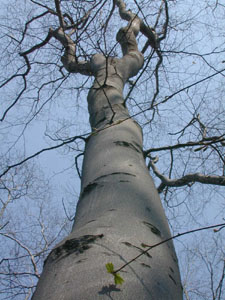
Le Bois Papineau est un parc naturel parmi les plus riches et diversifiés en milieu urbain au Québec. Le joyau du Bois, une hêtraie à érable à sucre très âgée, est situé sur une formation géologique particulière. Cette forêt est l’un des derniers exemples de la vallée du Saint-Laurent telle qu’elle devait être à l’arrivée des européens. C’est un écosystème forestier exceptionnel protégé.
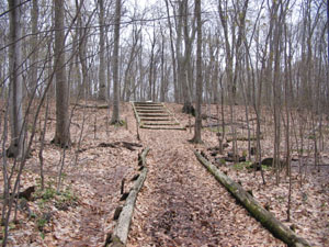
La hêtraie repose sur une longue butte de sable facilement observable à vos pieds (l’escalier derrière vous en donne la pleine mesure). Mais d’où vient tout ce sable? C’est une longue histoire!
D’abord il faut se souvenir qu’un énorme glacier recouvrait jadis cet endroit. L’Inlandsis Laurentidien a comprimé le continent et celui-ci s'est enfoncé. Puis le réchauffement du climat a entraîné la fonte des glaces. Le poids des grands glaciers était tel qu’après leur départ, le continent est demeuré enfoncé pendant plusieurs milliers d’années. Les eaux de l’océan Atlantique ont ainsi pu envahir cette dépression pour donner naissance à la Mer de Champlain qui a occupé la vallée du Saint-Laurent entre 12 000 et 9000 environ avant aujourd'hui.
Mais le relèvement du continent, à la recherche d’équilibre après la fonte des glaciers, a graduellement chassé ces eaux. Ce relèvement s'appelle isostasie et se poursuit encore aujourd’hui. De larges chenaux, comme des rivières, ont ainsi coulé à cet endroit. Beaucoup de sable a été transporté par l’eau et s’est déposé ici, où le courant ralentissait, pour former un banc de sable. Nous savons que ce banc de sable existe depuis 8000 ans environ, époque où l’eau s’est retirée pour être confinée au Saint-Laurent et à la Rivière-des-Prairies.
La présence de cette forêt ancienne s’explique donc par la formation géologique sur laquelle elle se trouve, mais aussi par l’histoire de l’occupation humaine de la région, des premiers occupants autochtones à aujourd’hui.
- Quelle position occupait ce terrain au début de la colonie et pourquoi cela a t'il contribué à sa conservation jusqu'à nos jours, alors que l’essentiel des forêts de la région sont disparues depuis longtemps?
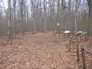
Vous trouverez au point désigné quatre panneaux d’interprétation sur lesquelles se trouve la réponse dont vous aurez besoin pour enregistrer votre visite (veuillez soumettre votre réponse au propriétaire et attendre la confirmation avant d'enregistrer - assurez-vous que je puisse vous rejoindre en m'écrivant directement ou en cochant l'option appropriée pour joindre votre adresse courriel à votre réponse). Profitez de votre passage pour faire quelques-unes des autres caches présentes au Bois, mais veillez à approcher les caches par les sentiers, et à rapporter vos déchets.
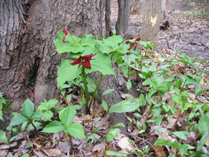
La gestion du Bois Papineau est assurée par l’Association pour la conservation du Bois Papineau (ACBP) qui, depuis sa création en 1986, œuvre pour la sauvegarde de cette enclave naturelle unique en milieu urbain au Québec. La hêtraie a été identifiée par le gouvernement du Québec comme écosystème forestier exceptionnel; seule une autre forêt aussi âgée existe au Québec en milieu urbain. Parce qu’il abrite plusieurs plantes menacées ou vulnérables, le Bois Papineau est aussi officiellement reconnu comme un habitat d’espèces en péril.
The Bois Papineau
An ecological and geological treasure in the heart of Laval
The Bois Papineau is a natural park among the most diversified in urban areas in Québec. The jewel of the woodland, an old-growth beech-maple forest, is located on a particular geological formation. This is one of the few lasting example of the pre-colonial forests of the St. Lawrence plain. It is a protected exceptional forest.
The beech stand grows on an ancient sandy ridge easily observed under your feet. But where did all this sand come from? It’s a long story!
First we need to remember that an enormous glacier covered this region a long time ago. The Laurentide Ice Sheet enormous weight caused the surface of the crust to deform and downwarp. Then the climate got warmer and the glaciers melted. The weight of all this ice was such that the continent remained depressed for several thousand years. Sea water from the Atlantic Ocean could thus penetrate and fill this depression, creating what was later named the Champlain Sea. It occupied the St.Lawrence valley between about 12 000 and 9000 years before today.
But the rise of the continent, seeking equilibrium after the glacier retreated, gradually flushed the water away. This phenomenon is called isostasy and still occurs today. Large channels were created and rivers carried the water away. Much sand was transported by the rivers and was deposited here, where the current was slower, to form this ridge. We know this sand ridge exist since 8000 years ago approximately, when the waters were concentrated below, approximately where the St.Lawrence and Rivière-des-Prairies now flow.
The presence of this forest is thus explained by the geological formation on which it stands, but also because of the particular human occupation history of the region, from the first-nations until today.
- Where was this land located at the start of the colony, and why did that contributed to its maintenance until today, whereas most forests have disappeared from the region long ago?
Four interpretation signs at the designated coordinates will provide the answer, which you will need to log your visit (please submit your answer to the owner and wait for the confirmation before logging your visit - please make sure I can reach you by emailing me directly or checking the option to send your email address together with your answer).
Important note. Unfortunately for our English-speaking visitors, the signs are in French only; sorry! If you cannot read them, please give me the number of steps in the stairs that are climbing the sand ridge. At least you will get a sense of just how much sand there is. But since Earthcaches are about learning, be prepared to receive the actual answer to the above question via email!
Take the time to find some of the other caches in the park, but please stay on the trails for as long as possible, and bring back your trash.
The Bois Papineau is managed by the ACBP (Association pour la conservation du Bois Papineau) which, since its incorporation in 1986, works for the protection of this unique wellspring of flora and fauna in an urban context. The old-growth beech-maple forest of the Bois Papineau is now a designated exceptional forest; it is one of the last two such forests located within an urban environment in Québec. Because it provides shelter to many endangered or vulnerable plant species, it is officially recognized as a habitat for species at risk.
Alain Paquette Ph.D., v.p. ACBP
Centre d’étude de la forêt, Université du Québec à Montréal (CEF)
Center for Forest Research, Université du Québec à Montréal (CFR)