Andritzer Plattenrunde Multi-cache
-
Difficulty:
-

-
Terrain:
-

Size:  (small)
Please note Use of geocaching.com services is subject to the terms and conditions
in our disclaimer.
EN: 11km hike from Andritz to Platte (651m) and back. Elevation change 300m, ascend/descend 370m.
DE: 11km Wanderung von Andritz auf die Platte (651m) und retour. Höhenunterschied 300m, Auf-/Abstieg 370m.
ENGLISH DESCRIPTION
Basic information
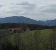
This cache leads from the heart of Andritz, the 12th district of Graz, to the top of the Platte, a 651 meter high rise north-east of the city.
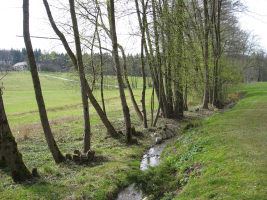
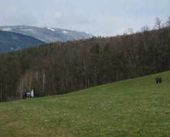
The route consists of paved roads with hardly any traffic, forest roads and trails along meadows and through forestal areas.
Even though this cache follows existing hiking trails on some parts of the route I still hope to be able to show something new to a few visitors.
If you want to look up the route on a map: Zelinkagasse - Ursprungweg - Rotmoosweg - Radegunder Strasse - Weizbachweg - #85a - "Koller" - 2. Plattenkreuz - Stephanienwarte - Plattensteig - 1. Plattenkreuz - Oberer Plattenweg - #85 - Pfeifferhofweg - Im Vogelsang - Pfeifferhofweg - Zelinkagasse
For some it might be possible to do this cache by bicycle but note that on some parts of the route it's not allowed to ride a bike.
The drive-in department might be interested to know that all questions that need to be answered are located at places where reaching them by car is either impossible, forbidden or all in all will take longer than walking the tour.
Nearby caches
It would make sense to take a print-out of Memory I oder Plattenwandertag (GCMBY2) and Stephanienwarte (GC1AE0C) with you if you haven't already found these two caches. While the latter is right next to this caches' route the first one requires a small detour.
Approach
The header coordinates are close to the bus and tram station "Andritz" which can be reached by public transport with tram lines 4 and 5 and bus lines 41, 52 and 53.
By bike the header coordinates are easily reachable by first following the R2 Murradweg and then the "Andritz" bikeway signs.
For cars there are some parking lots at the given parking coordinates (N47°06.157 E015°25.402). There are usually no cars there on weekends but during the week it might be necessary to look for an alternative parking location.
Route
At the header coordinates follow the street leading north-east until you reach the Schoeckelbach creek. There follow the bikeway (without crossing the creek) until you reach a street with a crosswalk (Rotmoosweg; WP1; N47°06.744 E015°25.510). To your left you see the Johanneshof, but we turn right and follow the street uphill. At a traffic light cross the street, but don't continue along the marked trail #85a. Instead follow the street a few meters to the south and then turn left (Weizbachweg; WP2; N47°06.602 E015°25.844).
First question - Q1 (N47°06.794 E015°26.754): How many mailboxes (for different households) are here? Result: A
At WP3 (N47°06.788 E015°27.407) keep left.
Second question - Q2 (N47°06.987 E015°27.370): At the A-shaped power pole you will find two small tags. One which is right above another small tag of the same size contains a letter and some digits - we are interested in the digits. Result: BC
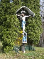
Follow the street through the homestead. There is a nice cross right after it on the right side.
WP4 (N47°07.152 E015°27.452) offers a nice view. Follow trail #85a in front of you (north-east direction) - don't turn left downhill or immediately right towards the forest. You will see the first trail marks as soon as you reach the forest.
Update Jan 2016: The paths in this area have changed in the last years as one is no longer allowed to walk by some nearby houses. From WP4 walk a few meters to the north and then follow the path into the forest towards Q3 (coordinates below). This used to be trail #85a which now bypasses the private area after Q3 on the south side.
Third question - Q3 (N47°07.254 E015°27.708): Number of letters of the last name of the person that died here. Result: D
Update Jan 2016: After Q3 please don't follow the old #85a trail that would go into now private property. Instead try to find a path leading south where you will reach the current (new) #85a that goes around the private area.
You will soon reach a street crossing. If you haven't found "Memory I oder Plattenwandertag" (GCMBY2) yet and have time for a small detour it would make sense to go for that cache. Otherwise keep on trail #85a until you reach the Stephanienwarte (WP5; N47°06.756 E015°28.173). If you haven't found "Stephanienwarte" (GC1AE0C) yet.. well you know.
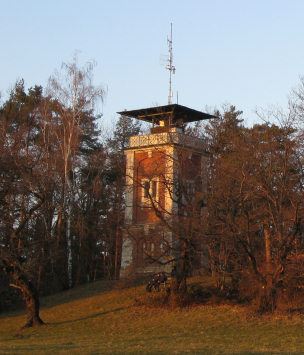
Fourth question - at WP5 (N47°06.756 E015°28.173): On the outside above the entrance portal (not next to the locked door inside!) you will find a plate with four lines of text. How many words are on the 3rd line? Result: E
(Note: It does not matter how you would write it, I am referring to the number of words on the plate)
Update Jan 2016: Since 2010 the tower is now open to visitors in summer on holidays and weekends from 10-19h.
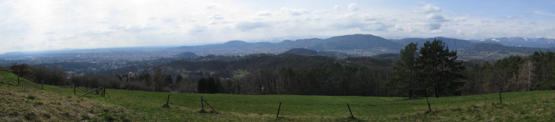
Follow trail #85 downhill towards WP6 (N47°06.680 E015°28.096) which offers another nice view.
Update Aug-24-2008: There is a new inn near the viewpoint, opened about one month ago. It offers both Italian and traditional food.
Update Jan 2016: The inn is closed since quite a while.
People who are hungry or thirsty can then visit Buschenschank Erart (Fri-Sun 14-22; N47°06.543 E015°27.799) and then continue on trail #85.
Note that the trail leaves the street at WP7 (N47°06.447 E015°27.479)!
Fifth question - Q5 (N47°06.451 E015°26.540): To your left you will see an unexpected object in some distance. It's (Result F): 2-blue, 5-silver, 7-gold, 9-red.
Update Aug-24-2008: Note that if you don't see the object due to vegetation take the next street to your left and follow it for a few meters.
You can use the nearby bench to calculate the final coordinates.
N47°06.E(B-2)(A+3)
E015°26.C(D-1)F
WP8 (N47°06.450 E015°26.437): Leave the street and follow the unmarked trail to your left into the forest.
WP9 (N47°06.344 E015°26.045): Leave the forest, follow the street downhill. At the next crossing go left, downhill. Then continue towards the header coordinates.
DEUTSCHE BESCHREIBUNG
Basic information
Dieser Cache führt vom Herzen von Andritz, dem 12. Grazer Bezirk, auf die Platte, eine 651 Meter hohe Erhebung nordöstlich der Stadt.
Die Route besteht aus asphaltierten Strassen mit wenig Verkehr, Forststrassen und Pfaden entlang von Wiesen und durch Waldgebiete.
Obwohl dieser Cache teilweise markierten Wanderwegen folgt so hoffe ich doch, dass ich damit einigen Besuchern etwas Neues zeigen kann.
Wenn man die Route auf einer Karte verfolgen will: Zelinkagasse - Ursprungweg - Rotmoosweg - Radegunder Strasse - Weizbachweg - #85a - "Koller" - 2. Plattenkreuz - Stephanienwarte - Plattensteig - 1. Plattenkreuz - Oberer Plattenweg - #85 - Pfeifferhofweg - Im Vogelsang - Pfeifferhofweg - Zelinkagasse
Für Einige wird es möglich sein diesen Cache mit dem Fahrrad zu absolvieren, allerdings sei darauf hingewiesen, dass das Radfahren auf einigen Teilen der Strecke verboten ist.
Die Drive-In-Abteilung wird es möglicherweise interessant finden dass sich alle Fragen an Stellen befinden, die mit dem Auto entweder nicht erreichbar sind, das Befahren verboten ist oder es im Gesamten länger dauern würde als die Strecke zu Fuss zu gehen.
Nearby caches
Es wäre sinnvoll einen Ausdruck der beiden Caches Memory I oder Plattenwandertag (GCMBY2) und Stephanienwarte (GC1AE0C) mitzunehmen wenn man diese beiden Caches noch nicht gefunden hat. Während Letzterer sich unmittelbar auf der Route dieses Caches befindet so muss man für das Suchen des ersten Caches einen kleinen Umweg machen.
Approach
Die Headerkoordinaten sind in der Nähe der Endhaltestelle "Andritz", die mit den Strassenbahnlinien 4 und 5 sowie den Buslinien 41, 52 und 53 öffentlich erreichbar ist.
Mit dem Rad sind die Headerkoordinaten ganz einfach über den R2 Murradweg und der Radweg-Beschilderung "Andritz" erreichbar.
Für Autos gibt es einige Parkplätze entlang der angegebenen Parkkoordinaten (N47°06.157 E015°25.402). Am Wochenende gibt es dort normalerweise genügend Platz, aber unter der Woche ist möglicherweise eine kurze Suche nach einem alternativen Parkplatz notwendig.
Route
Bei den Headerkoordinaten folge der Strasse die nach Nordosten führt bis du den Schöckelbach erreichst. Dort folge dem Radweg (ohne den Bach zu überqueren) bis du eine Strasse mit einem Zebrastreifen erreichst (Rotmoosweg; WP1; N47°06.744 E015°25.510). Zu deiner Linken siehst du den Johanneshof, aber wir gehen nach Rechts und folgen der Strasse bergauf. Bei einer Ampel überquere die Strasse, allerdings folge hier nicht dem Wanderweg 85a. Stattdessen folge der Strasse für ein paar Meter nach Süden und biege dann links ab (Weizbachweg; WP2; N47°06.602 E015°25.844).
Erste Frage - Q1 (N47°06.794 E015°26.754): Wieviele Postkästen (für verschiedene Haushalte) gibt es hier? Ergebnis: A
Bei WP3 (N47°06.788 E015°27.407) halte dich links.
Zweite Frage - Q2 (N47°06.987 E015°27.370): Bei einem A-förmigen Strommast findet du zwei kleine Plaketten. Eine befindet sich genau über einer anderen Plakette gleicher Grösse und ist mit einem Buchstaben und einigen Zahlen beschriftet - uns interessieren die Zahlen. Ergebnis: BC
Folge der Strasse durch den Bauernhof. Gleich danach befindet sich ein schönes Kreuz auf der rechten Seite.
WP4 (N47°07.152 E015°27.452) bietet eine nette Aussicht.Folge Wanderweg 85a vor dir (Nord-Ost Richtung) - gehe nicht nach links bergab oder gleich rechts in Richtung Wald. Die ersten Wegmarkierungen sind sichtbar sobald man den Waldrand erreicht.
Update Jan 2016: Die Wanderwege in diesem Bereich wurden in den letzten Jahren verändert und führen nun nicht mehr durch einen nahen Hof. Von WP4 gehe ein paar Meter nach Norden und folge dann dem Weg in den Wald bis Q3 (Koordinaten unten). Dieser Weg war früher Wanderweg 85a, der nun etwas weiter südlich an dem Hof vorbeiführt.
Dritte Frage - Q3 (N47°07.254 E015°27.708): Anzahl der Buchstaben des Nachnamens der Person die hier gestorben ist. Ergebnis: D
Update Jan 2016: Nach Q3 folge bitte nicht dem alten Wanderweg 85a durch den Privatgrund sondern suche einen Weg nach Süden, wo du nach kurzer Zeit den aktuellen Weg 85a erreichst, der den Privatgrund auf der Südseite umgeht.
Nach kurzer Zeit erreichst du eine Strassenkreuzung. Wenn du "Memory I oder Plattenwandertag" (GCMBY2) noch nicht gefunden hast, wäre dies ein guter Zeitpunkt, einen kleinen Umweg zu machen und diesen Cache zu holen. Ansonsten halte dich an Weg 85a bis du die Stephanienwarte (WP5; N47°06.756 E015°28.173) erreichst. Wenn du den Cache "Stephanienwarte" (GC1AE0C) noch nicht gefunden hast.. ehschonwissen.
Vierte Frage - bei WP5 (N47°06.756 E015°28.173): Auf der Aussenseite über dem Eingangsportal (nicht neben der versperrten Tür im Inneren!) findest du eine Tafel mit vier Zeilen Text. Wieviele Worte stehen in der 3. Zeile? Ergebnis: E
(Hinweis: Es ist egal wie man es heutzutage schreiben würde, es geht ausschliesslich darum wie es auf der Tafel geschrieben ist)
Update Jan 2016: Seit 2010 ist die Warte für Besucher im Sommer an Wochenenden sowie an Feiertagen von 10-19 Uhr zugänglich.
Folge Weg 85 bergab zu WP6 (N47°06.680 E015°28.096), der eine schöne Aussicht bietet.
Update Aug-24-2008: Beim Aussichtspunkt hat vor einem Monat eine neue Gaststätte eröffnet. Sie bietet sowohl Italienische als auch ortsübliche Speisen.
Update Jan 2016: Die Gaststätte ist seit geraumer Zeit geschlossen.
Leute mit Hunger oder Durst können den naheliegenden Buschenschank Erart (Fr-So 14-22; N47°06.543 E015°27.799) besuchen und dann Weg 85 folgen.
Beachte dass der Wanderweg bei WP7 (N47°06.447 E015°27.479) von der Strasse abzweigt!
Fünfte Frage - Q5 (N47°06.451 E015°26.540): Zu deiner Linken siehst du ein unerwartetes Objekt in einiger Entfernung. Es ist (Ergebnis F): 2-blau, 5-silber, 7-gold, 9-rot.
Update Aug-24-2008: Falls du das Objekt aufgrund der Vegetation nicht siehst so folge der naechsten Strasse zu deiner Linken für einige Meter.
Du kannst die naheliegende Bank nutzen um die Endkoordinaten auszurechnen.
N47°06.E(B-2)(A+3)
E015°26.C(D-1)F
WP8 (N47°06.450 E015°26.437): Verlasse die Strasse und folge dem unmarkierten Pfad zu deiner Linken in den Wald.
WP9 (N47°06.344 E015°26.045): Verlasse den Wald, folge der Strasse abwärts. Bei der nächsten Kreuzung gehe links, bergab, dann in Richtung der Headerkoordinaten.
Additional Hints
(Decrypt)
[EN] Ynetr orrpu gerr
[DE] Tebffr Ohpur