Kilgore Falls EarthCache EarthCache
-
Difficulty:
-

-
Terrain:
-

Size:  (other)
Related Web Page
Please note Use of geocaching.com services is subject to the terms and conditions
in our disclaimer.

Kilgore Falls
Kilgore Falls is part of the Rock State Park Maryland Park system which is a Trash Free facility. Please use CITO (Cash In Trash Out)

This cache has been approved by the Geological Society of America.and the Harford County Department of Parks and Recreation Permit #10-1
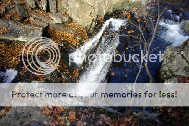 Viewing the falls from above.
Maryland's second highest free-falling waterfall is located on the Falling Branch Area of Rocks State Park. It is a 67 acre parcel of land which is home to Kilgore Falls, a scenic and tranquil section of Falling Branch, a tributary of Deer Creek in northern Harford County. The falls were well known to local native Americans and settlers, but in recent times the area was relatively unknown because the land was privately owned. Through the work of citizens groups, businesses, North Harford High School and government agencies the Falling Branch Area was added to Rocks State Park in 1993 and open to the public. This non-developed, environmentally sensitive area has a serene hiking trail leading back to the waterfall Falling Branch passes through a steep gorge known as Kilgore Rocks, where the falls have developed in relatively erosion-resistant Prettyboy schist. This formation was previously known as the upper pelitic schist of the Wissahickon formation. The falls are variously named by local residents Falling Creek Falls, Falling Branch Falls and Kilgore Falls.
The trail head is located just off the end of the parking lot and enters the woods which is a mix of hardwoods and hemlocks. Follow the marked trail to the first of two bridges. There are good views of substantial ruins on the opposite side of the Branch. The trail crosses two short bridges to the falls which are impressive.
++++++++++++++++++++++++++++++++++++++++++++++++++
Historic/Cultural Features:
“Three miles above the Rocks, a small stream empties into Deer Creek. This stream flows through a little known and secluded territory, flanked by forests and vines, almost hiding its natural beauty from the human eyes. The stream got is name of Falling Branch from the fact that a mile or more above the mouth, waters fall from a series of rocky cliffs 30 or more feet in height. The falls makes a picturesque setting, in an almost untrodden forest, and provides a scene of unique beauty. Nearby are the remains of stone steps, leading from the base of the rocks on which the waters fall. It would appear that these steps were constructed by the hands of man, but no record shows their age or whether they are the results of the labor of white men or some predecessor, such as the Susquehannock Indians. ["Our Harford Heritage” by C. Milton Wright] Prior to the development of the current site, there were the remains of an old mill and dwelling house belonging to the miller, Isaac Jones. On the west side of Falling Branch is an old stage coach route and that mill site near the waterfall. On the east side is the foundation of a stage coach rest stop below the falls.
+++++++++++++++++++++++++++++++++++++++++++++++++
What is a Waterfall?
A waterfall is usually a geological formation resulting from water, often in the form of a stream, flowing over an erosion-resistant rock formation that forms a sudden break in elevation. Some waterfalls form in mountain environments where the erosive water force is high and stream courses may be subject to sudden and catastrophic change. In such cases, the waterfall may not be the end product of many years of water action over a region, but rather the result of relatively sudden geological processes such as landslides, faults or volcanic action. Typically, a river flows over a large step in the rocks which may have been formed by a fault line. Over a period of years, the edges of this shelf will gradually break away and the waterfall will steadily retreat upstream, creating a gorge of recession. Often, the rock stratum just below the more resistant shelf will be of a softer type, meaning undercutting, due to splashback, will occur here to form a shallow cave-like formation known as a rock shelter or plunge pool under and behind the waterfall. Eventually, the outcropping, more resistant cap rock will collapse under pressure to add blocks of rock to the base of the waterfall. These blocks of rock are then broken down into smaller boulders by attrition as they collide with each other, and they also erode the base of the waterfall by abrasion, creating a deep plunge pool. Streams become wider and more shallow just above waterfalls due to flowing over the rock shelf, and there is usually a deep pool just below the waterfall because of the kinetic energy of the water hitting the bottom. Waterfalls can occur along the edge of glacial trough, whereby a stream or river flowing into a glacier continues to flow into a valley after the glacier has receded or melted. The large waterfalls in Yosemite Valley are examples of this phenomenon. The rivers are flowing from hanging valleys.
________________________________________________________________________
Types of Waterfalls
Block: Water descends from a relatively wide stream or river.
Cascade: Water descends a series of rock steps.
Cataract: A large waterfall.
Fan: Water spreads horizontally as it descends while remaining in contact with bedrock.
Horsetail: Descending water maintains some contact with bedrock.
Plunge: Water descends vertically, losing contact with the bedrock surface.
Punchbowl: Water descends in a constricted form, then spreads out in a wider pool.
Segmented: Distinctly separate flows of water form as it descends.
Tiered: Water drops in a series of distinct steps or falls.
Multi-Step: A series of waterfalls one after another of roughly the same size each with its own sunken plunge pool.
+++++++++++++++++++++++++++++++++++++++++++++++++++++++++++++++
To log the Kilgore Falls earthcache you must post a picture of you with your GPS with the falls in the background. DO NOT post your answers to the questions in the log. Email me the answers to the following questions:
1) Using your GPS what is the altitude at the top of the falls?
2) Approximately how high are the falls?
3) Approximately how wide are the Falls at the top?
4) How wide is the pool at the base of the falls?
5) How do you think that the falls was formed?
When you arrive at the posted coordinates you will find a small parking lot adjacent to Falling Branch Road. At certain times of the year, normally in the summer, this parking lot can be very crowded. Please DO NOT park on Falling Branch Road. Park only in the posted parking areas. Also do not park on the nearby dirt road. And when in the park, please stay on the marked trails to avoid damage to the surrounding environment.


 I am Proud to be PLATINUM Level EarthCache Masters!
Additional Hints
(Decrypt)
Gur genvy pna or irel fyvccrel qhevat naq nsgre enva be fabj. Fb, or pnershy.