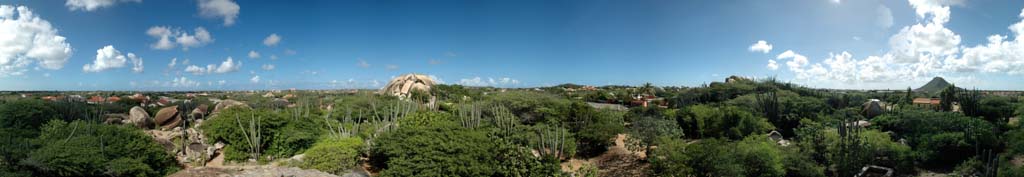
360° panoramic picture taken from the second highest viewpoint at the Casibari Rock Formation
Earth cache
[EN] Welcome to this unique and notable geological site. You are at what is called the Casibari Rock Formation. A path accompanied by several stairs will lead you to the top of these giant boulders.
- 1a But before you take the path, measure the altitude at the bottom of the boulders by using your GPS device.
Take the stairs to enjoy the great panoramic view of Aruba’s landscape. On a clear day you might even be able to see all the way to Venezuela.
- 1b After walking your way up, measure the altitude at the highest point of the boulders by using your GPS device.
- 1c Now subtract the two gained values to get an estimate height of these boulders.
The reddish brown rocks you are standing on are composed of diorite. Diorite is an igneous rock, meaning it is created through the cooling and solidification of magma or lava. However, this process did not give them their unique shapes which you can see nowadays.
- 1d Reason how these boulders got their unusual shapes which you can see nowadays. Back your thoughts up with arguments.
Enough about these boulders. Let’s observe the surroundings for a bit. It will be hard to ignore the 165 meters high hill within your view. This is the Hooiberg, which seems like the highest point of the Island, but is in fact the second highest, due to Mount Jamanota being 188 meters high.
- 2a (optional) It would be great if you could upload a photograph of yourself with your GPS where you can see the Hooiberg in the background.
This volcanic formation got its name probably due to its shape, for the Dutch word ‘Hooiberg’ literally translates into ‘Haystack’. The mountain is made up of a distinctive variety of quartz diorite only found on Aruba. For this reason, the quartz diorite variety is named after the Hooiberg.
- 2b Reason what the name that is given to this unique variety of quartz diorite could be, based on the information above. Note that rock varieties often end with -ite.
A depiction of Hooiberg can also be seen on the Aruban Coat of Arms. It symbolizes Aruba rising out of the sea. You can see the Coat of Arms in the background of this cache page. At this point I will leave you on your own.
Have a great time Geocaching,
Mapachitl
Logging rules
[EN] To log this cache as a ‘Found it’ you have to send me the answers to the assignments that you can find in the cache description.
- Try not to include any answers or hints in the log itself other than the optional photographs.
- Feel free to place a log before getting a response. I will contact you if you have sent me incorrect or incomplete answers.
- I will remove logs which are not accompanied by a mail or personal message containing your answers.
- Earthcaches are partly about education. Therefore put some thought in your answers.
