The Park of a Hundred
Flowing Wells - The Site of
Equadon
The Springs
of Prentice Park have attracted men to this pure and healing
water, for ages. The park occupies the site of an old Indian
Settlement call Equadon, a Chippewa word meaning ‘settlement
near the head of the bay.’ The park and springs have had
several names; Webb Springs, Mineral Springs and Prentice
Springs. The park was named after Frederick Prentice who had
established the brownstone quarries on Hermit Island and
Houghton Point (Apostle Islands); he bought the park in 1887
and built it up. In 1921 Prentice Park was officially given
to the City of Ashland. A connection to Prentice Park was a
nursery operated by a Charles Maslowski. He established a
nursery on these grounds for the purpose of raising trees and
shrubbery for the parks of
Ashland.
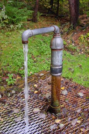
The
weathered boardwalks and trails of the Fish Creek slough area
are a popular attraction in the 100-acre Prentice Park. After
your hike take a drink from one of the three artesian wells
located the park. One of the wells is a large diameter free
standing pipe located in the middle of a small damned pond,
the one that stands before you is smaller and perfect for
filling your water jugs. Bring your binoculars and hike out to
the boardwalk bridge that spans part of the slough area. From
this location you are perched for fantastic viewing…you might
even catch a glimpse of one of the resident mute
swans!
“The springs are part of a great waterworks
system, that has it source in the Great Watershed or Great Divide,
where we placed a marker last summer, 39 miles south of Ashland, by
Highway 13, three miles north of Gordon Lake. This watershed 20
miles wide, receives and stores the waters that flow north into
Lake Superior, or southwesterly into the Mississippi River. The
surface water comes down to Lake Superior through the Bad River, or
southwesterly through the Chippewa River, into the Father of
Waters. The greater part of the water sinks into the earth; forming
an inexhaustible supply that comes underground some of it emerges
into Lake Superior. In some places, the underground supply comes to
the surface as it does here in this park. It is as if great pipes
from 25 to 40 miles long connected the subterranean water supply of
the watershed with Lake Superior. Some of these pipes end here, in
this park of a hundred flowing wells. The supply of water will
last, as long as rain continues to fall on the Penokee Hills and
the watershed of northern
Wisconsin.”
- Guy M.
Burnham, The Ashland Daily Press - July 6, 1933 
The Copper
Falls Aquifer provides the water source for these artesian
wells. Porous stone is sandwiched between a top and bottom
layer of an impermeable substance like clay or
rock. This keeps the water pressure high, so that when you
get to a point below the entryway of the flow, there is enough
pressure (artesian pressure) to bring the water up. The water in
the aquifer is also under enough pressure that, when the aquifer
is tapped by a well such as this, the water rises up the well
bore to a level that is above the top of the aquifer called the
potentiometric surface.
The temperature of the water from
artesian wells is generally constant because of its depth.
Depending on the well depth the water temperature can be a few
degrees above the annual mean temperature. The water temperature
decreases about 1 °F for each 65 feet of depth to the well. The
mean annual temperature for the Ashland, WI region is 41 °F. Some
uses of these temperature differences have been to “heat” homes
(heat pump) and or cool them.
TO LOG THIS CACHE:
1) Determine the
output of the well in gallons per minute (gpm) and/or measure the
temperature of the water
(°F).
E-mail
be the answer(s)
HERE.
Sources: