The region measures aprx. 250 square
kilometres and is enclosed roughly within the circle comprised by
the villages Ballyvaughan, Kinvara, Tubber, Kilnaboy, Kilfenora and
Lisdoonvarna, It is bounded by the Atlantic and Galway Bay on the
west and north respectively. Burren is also rich with historical
and archeological sites. There are also many megalithic tombs in
the area and portal dolmens
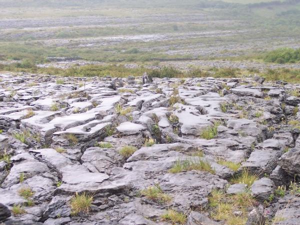
The rolling hills of Burren are composed of
limestone pavements with crisscrossing cracks known as "grikes",
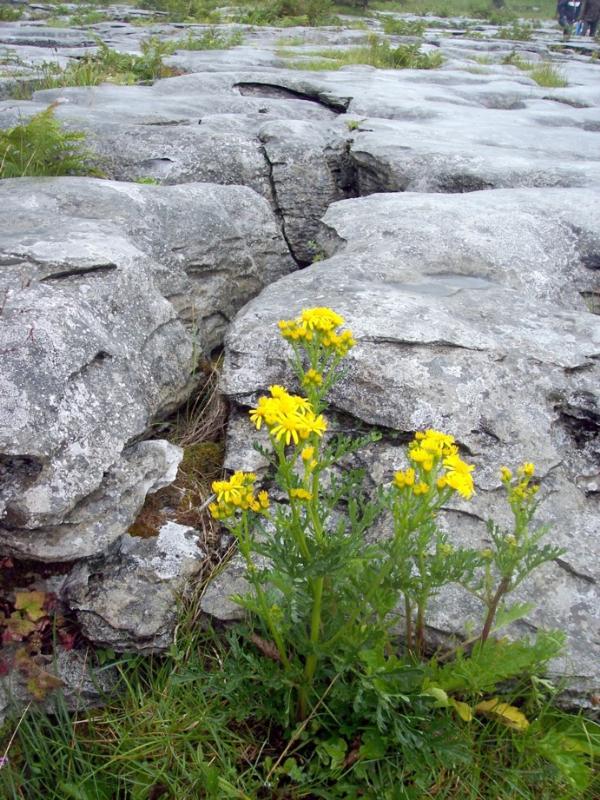
leaving isolated rocks called "clints". The region supports Arctic,
Mediterranean and Alpine plants side-by-side, due to the unusual
environment.
The word "Burren" is a corruption of an
Irish word, boireann, meaning a stony place.
This particular part of northern County
Clare is distinctive because of the character of its stoniness: an
upland region of exposed carboniferous limestone. Such landscapes
are known to geologists as "karstic" or "karst", a Germanic term
originating from Karst a limestone plateau near Trieste, in
northern Italy., The hills in this area display the full range of
landforms characteristic of a karstic landscape: flat blue-white
sedimentary rock layered in horizontal beds; expanses of limestone
pavements and platueaus; dramatic hillsides moulded by glacial
activity into stepped terraces; and a whole world of micro-erosion
features collectively called "karren".
Limestone is a porous rock susceptible to
erosion by water. Once exposed to the air, the limestone pavements
are etched by the weather into a distinctive series of solutional
features or karren - clints, grykes, rills, runnels. These quickly
convey all surface-water to underground streams (caves); hence the
absence of rivers or marshes. Geologists and palaeo-botanists think
that the Burren was mantled in a thin mineral soil supporting a
light forest canopy c.6,000 years ago. With the arrival of
agriculturalists, the process of clearing the forest for grazing
land began. Over the succeeding millennia much of the thin soil
cover has been gradually washed down into the grykes in the
limestone. Ironically, the widespread grazing of farm animals helps
keep the pavements bare of soil!
Due to the porous nature of limestone most
of the rain and surface water drains down through the crevices in
the rock until it meets some impervious layer, usually a lense of
shale. It then begins to flow horizontally. In the process, the
water further erodes the rock carving out smooth walled passages,
channels and even large chambers. The Burren caves come in two
categories, and dry and active, i.e. still occupied by streams.
Over 300 miles of caves have been mapped in to Burren to date
making it a mecca for Speleologists or pot-holers.
Find the part of Burren
where you can see the megalithic tombs of Poulnabrone Dolmen in the
unique karst-landscape. Its nice to take a picture (you and the
megalithic tombs and of course the karst landscape there) Photo is
not obligation But it should be a matter of honor for Earth
Caches
Please
mail me the coordinates of Poulnabrone in Burren
and answer follow questions:
1. Estimate the width of the opening in the
dolmen
2. Of
which minerals does limestone consist?
3. Call
3 other special karst landscapes in the world.
Please,
don’t log the coordinates and the answers!