The National Geodesic
Network
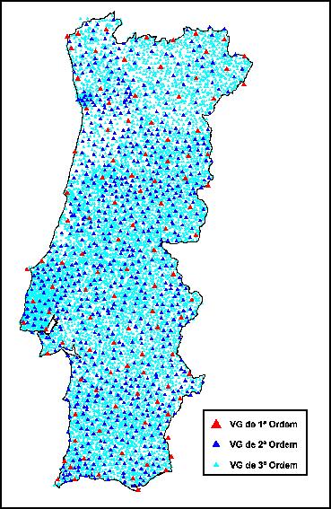
The National Geodesic Network (RGN) is composed by
a set of coordinate points - Geodesic Vertexes - that make spatial
referencing possible.
The number of existing vertexes on the whole
territory (Continental Portugal and Autonomous Regions) is,
currently, of about nine thousand, and they are distributed in
vertexes of: Continent: 1st Order (about 120),
2nd Order (about 900) and 3rdOrder (with an
approximate density of 1 vertex per 10 km²); Archipelago of Azores:
about 500; Archipelago of Madeira: about 150.
The RGN is the basic infrastructure that supports
all the cartography of the Country, and that it serves all those
(public and private companies, autarchies and other organisms)
that, because of their activities, need to reference their projects
geographically (the Municipal Director Plans, for
example).
A Rede Geodésica
Nacional
A Rede Geodésica Nacional (RGN) é composta por
um conjunto de pontos coordenados -
Vértices Geodésicos - que possibilitam a referenciação espacial.
O número de vértices
existentes na totalidade do território (Portugal Continental e
Regiões Autónomas) é, actualmente, de cerca de nove mil, repartidos
por vértices de:
Continente: 1ª Ordem
(cerca de 120), 2ª Ordem (cerca de 900) e 3ª Ordem (com uma
densidade aproximada de 1 vértice por cada 10 km²); Arquipélago dos Açores: cerca de 500;
Arquipélago da Madeira: cerca de 150.
A RGN é a infra-estrutura
básica onde se apoia toda a cartografia do País, e que serve todos
aqueles (empresas, autarquias e outros organismos públicos e
privados) que, por força das suas actividades, necessitam de
referenciar geograficamente os seus projectos (os Planos Directores
Municipais, por exemplo).
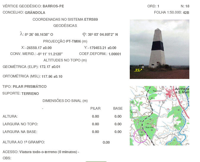
The
Geodesic Vertex Barros-PE
Locally known as "gurita", the landmark
that I propose that you visit is an extremely impressive and
imposing structure. Here’s a summary of the
place:
O Vértice Geodésico
Barros-PE
Localmente
conhecido como "gurita", o marco que
vos proponho visitar é uma estrutura realmente impressionante e
imponente.
Aqui está um resumo do local:
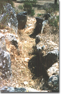
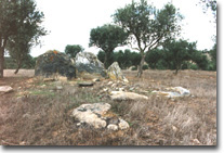
LousalMegalithic Monument
About 900 metres SW of the geodesic landmark
there’s a megalithic tapir that you might be interested in
visiting.
O Monumento Megalítico
do Lousal
Cerca de 900 metros a SO
do marco geodésico existe uma anta megalítica que poderão
considerar interessante visitar.
|
Localization
:
Localização
:
Setúbal, Grândola, Azinheira dos Barros
Protection
:
Protecção:
IIP, Dec. nº 29/90, DR 163 de
17 Julho 1990.
Framing
:
Rural, half hillside,
isolated. In a hillside dominating a small valley with a water
course.
Enquadramento:
Rural, meia encosta, isolado. Numa encosta dominando um pequeno
vale com curso de água.
|
|
|
|
|
Description:
Longitudinal plant composed by rectangular
gallery, polygonal main crypt and secondary crypt or great niche,
elliptical, separated from the main crypt by a passage with
"septos", oriented according to a axle
E/W. with entrance to the E. Gallery marked by 5
"esteios", 2 on one side, 3 on the
other, one of them of great dimensions; Main crypt with 8
“esteios", the biggest with about
of 2 metres of height; secondary crypt formed by 9 lower
"esteios".
Descrição:
Planta longitudinal composta por
galeria, rectangular, cripta principal poligonal e cripta
secundária ou grande nicho, elíptica, separada da cripta principal
por passagem com septos, orientado segundo um eixo E. / O., com
entrada a E.. Galeria marcada por 5
esteios, 2 de um lado, 3 do outro, um deles de grandes dimensões;
cripta principal com 8 esteios, o maior com cerca de 2 m.
de altura; cripta secundária formada por
9 esteios mais baixos.
|
|
Initial
purpose:
Funerary
Utilização Inicial:
Funerária
Time of Construction:
Eneolithic, c. 2000 b.C..
Época de
Construção:
Eneolítico, c. 2000 a.C..
Chronology:
about 2000 b.C. - construction - occupation until about
1700 b.C. (calcolithic) - metallurgic people established in
the mining zone.
Cronologia:
cerca 2000 a.C. - construção - ocupação até cerca 1700 a.C.
(calcolítico) - povo metalúrgico
estabelecido na zona mineira.
Typology:
Scientific place. Megalithic monument showing influences of the
almeriense civilisation, repeating the
planimetry of the tombs of Alcalar: a great niche connected to a tomb with
dolmenian
characteristics.
Tipologia:
Sítio científico. Monumento
megalítico mostrando influências da civilização almeriense, repetindo a planimetria dos túmulos de Alcalar: um grande nicho ligado a um sepulcro com
características dolménicas.
Particular aspects:
Originally covered by mamoa of great
dimensions, of which there still remain some
vestiges.
Características
Particulares:
Originalmente coberto por
mamoa de grandes dimensões, de que
ainda subsistem vestígios.
Access to the place:
You must follow the
EN. 120 that leads to Lousal.
In N38º 01,841 W008º 25,921 turn left. Follow the road straight on
and pass the stream. Beware of the water level: in the winter the
floods make this access impossible to use.
Go up the hill and pass the Mount of the Lousal.
In N38º 02,379 W008º 26,512 take the right and then always follow
this road until you pass next to some old houses on the left
side.
At the end of the landslide, on the right side, at N38º 02,601
W008º 26,333, you’ve got the Megalithic Monument of
Lousal. The monument has a fence around
it, you shouldn’t not cross it for
any purpose.
You’re now very close to the geodesic landmark. Follow the
road, that’s in a lot worse condition than until there, until
you arrive at the landmark, perfectly visible from since the
Megalithic Monument. Once more you'll have to pay attention to the
water level of the stream; it really rises in the winter.
On the hill through which the road passes, right until the
landmark, there are some beehives, so it’s convenient that
you take the necessary precautions.
During the winter the access we recommend is from
Azinheira de Barros. There you must
follow the directions to the rail station, and after this follow
the road, in the direction of Lousal,
until you reach the Geodesic Landmark. If there’s a flood the
Megalithic Monument will be inaccessible.
In the end you can download a file
with both recommended paths to get there.
Acesso ao
local:
Devem seguir a EN. 120
que leva a Lousal. Em N38º 01.841 W008º 25.921 virar à
esquerda. Seguir a estrada sempre em frente e passar o riacho.
Atenção ao nível da água: no Inverno as cheias tornam este acesso
impraticável. Sobem a encosta e passam pelo Monte do Lousal. Em N38º 02.379 W008º 26.512 viram à direita
e seguem sempre por essa estrada até passarem junto de uns
barracões do lado esquerdo. No fim da descida, do lado direito, em
N38º 02.601 W008º 26.333, têm o
Monumento Megalítico do Lousal. O
monumento está vedado, não convém passar a rede e andar lá por
dentro.
Para chegar ao marco
geodésico já falta pouco. É seguir a estrada, que é francamente
pior do que até aí, até chegar ao marco, perfeitamente visível
desde o Monumento Megalítico. Mais uma vez há que ter atenção na
passagem pelo riacho, o nível da água aí sobe realmente muito no
Inverno. Na colina da estrada até ao marco existem colmeias,
portanto é conveniente tomar as devidas precauções nesse
aspecto.
Durante o Inverno o acesso
recomendado é por Azinheira de Barros. Aí, devem seguir as
indicações na direcção da estação, e depois disso seguir pela
estrada, na direcção Lousal, até chegar
ao Marco Geodésico. Se houverem cheias, o Monumento Megalítico
ficará isolado.
No fim está um ficheiro
com ambos os acessos para chegar à cache.