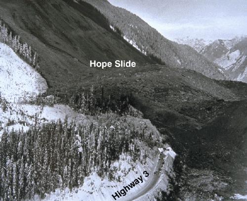
Early Saturday morning, on January 9th, 1965, the largest earth
and rock slide in the history of British Columbia occurred and left
its permanent mark on the residents and environment of the Hope
area and surroundings.
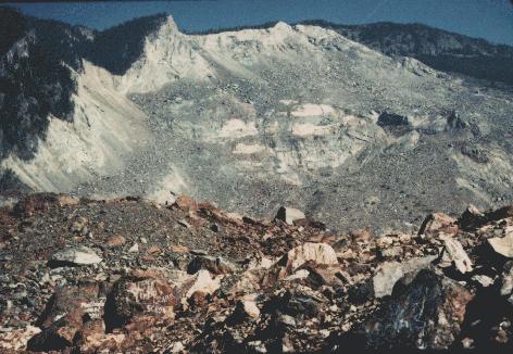
Supposedly triggered by a minor earthquake, about 46 million
cubic meters of rock and debris tumbled down the 2000 meter high
southwestern slope of Johnson Peak. Later, it was determined that
the failure occurred along felsite sheets and joint planes within
metavolcanic rocks of the Hozameen Group (for those real
geology-buffs). The power of the slide was so intense that the
rock’s momentum swept it up the opposite side of the valley bottom
(a boundary that is easily visible today where the older trees
clearly meet a younger forest) for some hundreds of meters of
vertical height. When the rock fall finally did settle in the
valley below, the new material had filled the bottom of the valley
to a depth of 85 meters (300 feet). Luckily, the slide occurred in
an unpopulated area in the early morning hours and the disaster
only resulted in four deaths, all of which were buried under the
rubble. All four were stuck on Highway #3 at the time, waiting for
a smaller initial slide to be cleared from the highway (see the
website link below for some more information on the relationship
between this slide and the major one). Two of the bodies were never
recovered by search crews and remain wherever they lie.
The slide itself destroyed approximately three kilometers of the
Hope-Princeton Highway #3 and temporarily blocked and rerouted the
river that ran along the valley. The view created by the disaster
has become quite a popular attraction among visitors to Hope. The
extent of the slide is still completely visible, as the side of the
mountain where the slide occurred is mostly bare of trees or
grass.
Landslides are a common occurrence in British Columbia due to
our province’s steep, mountainous terrain, its complex geology, its
high precipitation, both as rain and snow, its abundance of
unconsolidated glacial sediments, and its geographic position on
top of the earthquake zone that surrounds the Pacific Ocean. In
fact, in British Columbia the loss of life and damage to property
caused by landslides is greater than losses caused by other natural
hazards such as earthquakes and flooding.
To log this Hope Slide Earthcache as a find:
Email the owner the answers to the following questions:
1.What was the original elevation of the road?
2.What lake was buried?
Take a picture of yourself and your group with your GPSr and the
slide in view and post it in your log entry.
The easiest spot to do this is at the pull-out viewpoint
along Highway 3.
For further (somewhat technical) insight into how Johnson Peak
was potentially susceptible to a major landslide, check out the
following website, which describes some new research into the
inherent stability of the landslide area dating back some 10,000
years. View
link - Hope Slide.