Les Bisses: 1 Le Bisse du Rho Traditional Geocache
Les Bisses: 1 Le Bisse du Rho
-
Difficulty:
-

-
Terrain:
-

Size:  (regular)
Please note Use of geocaching.com services is subject to the terms and conditions
in our disclaimer.
| [FR] |
Cette cache est la première de la série des caches sur les bisses du Valais central. |
| [EN] |
This cache is the first one of the series of the "bisses" located in the central part of the Valais. |
Les Bisses: 1 Le Bisse du Rho
| [FR] |
Le chemin pédestre complet est à déconseiller aux personnes sujettes au vertige et aux enfants en-dessous de 8 ans. Le début du sentier a été sécurisé il y a quelques années. Le sentier du Bisse du Rho est fermé durant la saison d'hiver. Se renseigner à l'office du tourisme.
|
| [EN] |
The full trial is not recommended for people who suffer from vertigo and children under 8 years old. The beginning of the trial has been secured a few years ago.
The path of the "Bisse du Rho" is closed during the Winter saison. Check at the local tourist office.
|
|
[FR]
|
Le bisse, un nom étrange d’origine lointaine, est dérivé du gaulois "bids".
Dans le passé, les bisses jouaient un rôle économique inestimable. Pays de roc et de soleil fréquemment balayé par le foehn, le Valais aurait été quasiment désertique sans ces constructions. Nos ancêtres furent très tôt conscients que, pour fertiliser leurs cultures, l’eau des glaciers leur était vitale. Ce n’est toutefois qu’au XIIe siècle que remonte l’aménagement du premier bisse, qui reliait Salquenen à Varen.
|
|
|
Le Bisse du Rho
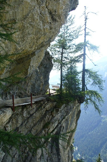
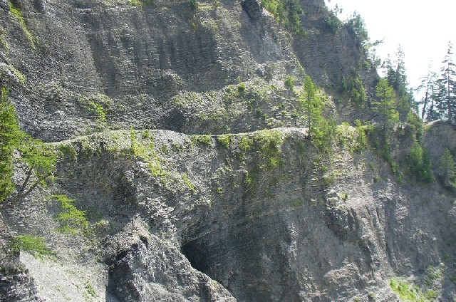
Le Bisse du Rho est certainement le vestige le plus ancien et le mieux conservé de l’histoire du Haut-Plateau. Il a été construit au XVe siècle. Il prend naissance à 1700 m dans la vallée de l’Ertenze. Sur une distance de 5 km, il chemine, en accusant une dénivellation de 100 m, le long des parois rocheuses pour franchir par endroits des passages en surplomb.
|
|
[EN]
|
The word "bisse", a strange name of distant origin, is derived from the Gallic "bids".
In the past, these “bisses” (or irrigation canals) played an inestimable economic role. A land of rocks and sunshine frequently swept by the “foehn” (a warm south wind), the Valais would have become practically a desert without these amenities. Even in far-off times, our ancestors fully realised that they vitally required the waters from glaciers in order for their crops to grow. Yet the construction of the first “bisse”, linking Salgesch and Varen, dated back only to the 12th century.
|
|
|
The “Bisse du Rho"
The “Bisse du Rho" is certainly the most ancient and the best preserved vestige in the history of the Haut-Plateau. Built in the 15th century, it starts out at an altitude of 1700 m in the Ertenze Valley. It makes its way for 5 km, including a fall in altitude of 100 m, past rocky walls and crosses certain passages overhanging a sheer drop.
|
|
[FR]
|
La cache
Possibilité de laisser les Cachemobiles sur le parking de la Garderie Canine, Route de Plans-Mayens au pt WA-PARK.
La cache se trouve environ 165m après le début du sentier (point WB-START). Il faut absolument rester sur le sentier; la boîte est atteignable depuis le sentier.
|
|
[EN]
|
The cache
You can leave your Cachemobile in the car park located at the "Garderie Canine, Route de Plans-Mayens"; waypoint WA-PARK.
The cache is located about 165 m after the start of the trail (waypoint WB-START). It is imperative to stay on the path; you can reach the box from the path.
|
|
[FR]
|
Le chemin pédestre du Bisse du Rho
La promenade reste probablement l’une des plus attractives de la région la vue sur la vallée de la Lienne étant de toute beauté.
Le sentier commence derrière la buvette au point WB-START. Il suit le bisse sur env. 4,5 km et monte de 100 m.
A plusieurs endroits, le chemin est suspendu dans la paroi rocheuse (voir la galerie photo).
Table de pique-nique couverte à mi-chemin le long du bisse (env. 25-30 minute du départ).
Plus loin se trouve la nouvelle passerelle suspendue "Passerelle du Noir" située à 45 minutes de marche du parking et sa cache "Les Bisses: 2 La Passerelle du Noir".
Tables de pique-nique avec grill à la fin du chemin pédestre et une autre cache a découvrir (GC13YNH).
|
|
[EN]
|
The Trial of the "Bisse du Rho"
This walk is doubtless one of the most attractive this region has to offer; the view over the Lienne Valley is stunningly beautiful.
The path starts behind the refreshment stand at the waypoint WB-START. It follows the "bisse" for 4,5km and climbs 100 m.
In several places, the path is cut into the rock face (visit the photo gallery).
A covered picnic table is located at the halfway point on the trail (ca.25-30 minutes walk from the start).
Further on is the new suspended footbridge "Passerelle du Noir" located 45 minutes walk from the car park and its cache "Les Bisses: 2 La Passerelle du Noir".
Picnic tables with fireplace at the end of the trail and there is another cache to discover (GC13YNH).
|
| |
 |
 |
| [FR] |
Par endroit, le bisse est taillé dans la falaise |
Le sentier suit le bisse sur 4,5 km |
| [EN] |
In some places, the "bisse" is cut into the cliff |
The path follows the "bisse" for 4,5 km |
Additional Hints
(Decrypt)
SE: Cyndhr pbzzézbengvir.
RA: Pbzzrzbengvba cyndhr.