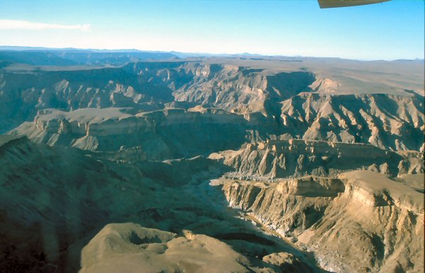
When you arrive at the canyon, as you have no idea it is there. It drops vertically by half a kilometre, out of a flat arid plateau without any warning. As with most rivers in Namibia the Fish River is generally dry however in the raining season (January to April) the river can become a raging torrent. The official view points can be found around Hobas, a camp site, 70 km north of Ai-Ais. From the parking lot it is just a short distance to the viewing area, also accessible for wheelchairs.
WARNING. Fish River Canyon has a steep cliff. Do not approach the edge.
Keep children under close supervision at all times.
The Fish River Canyon in Namibia is reputedly the second largest canyon in the world and is absolutely magnificent and breathtaking in its immensity. It features a gigantic ravine, in total about 180 km long, up to 27 km wide and in places almost 550 metres deep. It has been gouged out of the surface of the land in the course 650 million years by the forces of water, wind and gravity. However the canyon was not only created by water erosion, but through the collapse of the valley bottom due to movements in the earth's crust. The river cuts deep into the plateau which is today dry, stony and sparsely covered with hardy drought resistant plants such as succulents. At the lower end of the Fish River Canyon, the hot springs resort of Ai-Ais provides an oasis in the desolate rocky wastes.
Requirements for claiming this Cache
To get credit for this Earthcache please answer the following Study Questions and send us your findings. It would be nice if you post a picture of the Fish River Canyon in the background. Please do not post any answers with your log.
Study Questions:
1. Describe in your own words how this Canyon was formed.
2. There are three main colours of rock formations, what are those colours?
3. At the bottom of the Canyon, hot springs can be found. Which chemical element can be found in those springs?
4. The decent into the canyon is very steep; therefore some sections have a handrail. What is the handrail made of?
5. The Ministry of Wildlife, Conservation and Tourism requires a certificate before hiking the Canyon. What kind of certificate is required?
6. Why is the Canyon closed for hikers in summer time? Do you know both reasons?
Die Fragen auf Deutsch:
1. Beschreibe in deinen eigenen Worten wie der Canyon hier entstanden ist.
2. Es gibt drei Farben der Gesteine die überwiegen, welche sind das?
3. Am Boden des Canyons gibt es heiße Quellen. Welches chemische Element kann man darin feststellen?
4. Der Abstieg in den Canyon ist sehr steil, deshalb gibt es in einigen Sektionen Handläufe. Aus was bestehen diese Handläufe?
5. Das Ministerium für Wildlife, Conservation and Tourism verlangt eine Bescheinigung bevor es eine Genehmigung für den Abstieg in den Canyon erlaubt. Was für eine Bescheinigung ist vorzulegen?
6. Warum ist der Canyon den Sommer über geschlossen, bitte nenne beide Gründe.
Geology
Formation started about 1.8 million years ago with sandstone, shale and lava deposits which compressed and heated up to over 600°C. The metamorphosed rock re-crystallised and changed appearance. Dolorite lava, which never reached the surface, cut through in dark black lines about 650-900 million years ago, and the first major period of erosion started soon after, exposing and levelling the rocks. This became the floor of a shallow sea that covered the southern part of Namibia, upon which sediments were deposited. The base of the Nama sediments is only a few metres thick and consists of small pebble conglomerate. Above this are 150-200m (487-650 ft) of black limestone, grit and sandstones. These are capped by 10 metres (32 ft) of shale and sandstone. Fracturing of the crust about 500 million years ago formed a north-south valley and slow erosion removed the upper layers. Then about 300 million years ago glaciers of the Dwyka Ice Age and another period of fractures deepened the valley. Through these faults emerged ground water, bubbling up as hot springs. Most of the striking features of the canyon developed over the past 50 million years, and today it is one of the most scenic and impressive canyons in the world.

Other Information
The Fish River Canyon area has a typical semi-desert climate. During the hot summer months (October - March) temperatures can rise up to 48 degrees Celsius during the day and cools down to about 30 °C at night. Relief from the heat comes in short spells with occasional thunder storms. The average annual rainfall in the canyon area is 100 mm. During the short winters, temperatures can go down below zero at night, but quickly picks up during the day to a moderate 20 to 28 °C.
There is a five-day Fish River Canyon Hike is one of the most popular hikes in Namibia. The 85km trail starts from the view site situated on the lip of the Canyon about 12kms from the Namibia Wildlife Resorts camping site at Hobas, takes 5 days, with absolutely no facilities whatsoever. You have only what you carry on your back and whatever water you can find in semi-permanent pools. From the view site, the hikers descend steeply down the side of the Canyon for one to two hours dependant on how one's knees can take the pressure. Some sections at the beginning of this downhill are extremely steep and have a handrail to help. The hike ends at the hot springs of Ai-Ais and is only open between 15th April and 15th September. Bear in mind that you must book the trail well in advance, and you need a certificate before being allowed to commence the walk.
Links and Resources
Canyon Formation:
Fish River Canyon:
Fish River Canyon Hike:
Fish River, Ai-Ais, and Hobas: