EarthCache : De Hoge
Hil
De kustduinen van Nederland zijn gevormd in het Holoceen,
en net als bij het zeekleilandschap spelen de wind, het water en
zoutminnende
plantjes een grote rol bij de totstandkoming van het
landschap.
De duinen in Nederland vormen de bovenkant van strandwallen.
Ze bestaan uit zand van de bodem van de zee of uit rivieren.
Maar hoe komt het zand van de bodem van de zee op het land
terecht?
We kunnen zeggen dat dit vooral gebeurt door de getijstromingen en
de golfwerking.
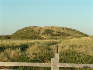
De hoogste duinen van Nederland liggen bij Zoutelande. Een mooi
uitzicht over de Walcherse
duinen heb je bij Domburg op de "Hoge Hill"
N51 33.793 E3 29.444
Om deze Earthcache te loggen maak je een foto van jezelf (waarop ik
duidelijk de persoon(en) kan zien) op de "Hoge Hill" en mail
mij
drie namen die je op de stenen platen vindt.
The coast dunes of the Netherlands originate from the Holocene
period.
As is the case with the sea clay scenery, the wind, water and salt
loving
plants play an important part in the creation of the scenery.
The dunes in the Netherlands are on the upper side of the
banks.
They consist of sand from the bottom of the sea or rivers.
The question that rises is: how is it possible that sand from the
bottom of the sea ends up on top of the dunes.
The answer is that this primarily happens because of the tidal
flows and the wave movements.
Near Zoutelande you will find the highest dunes of the
Netherland,
an very nice overview about the dunes of Zeelande you will find at
the "Hoge Hill" near Domburg at
N51 33.793 E3 29.444
To log this Earthcache take a Photo of you (front with face) at the
Top of "Hoge Hill" and have a look to the Stones
there. Please send me an eMail containing the names of three stones
and your estimation of the height of the dune.
Die Küstendünen der Niederlande stammen aus dem Holozän.
Wie im Fall der maritimen Marsche spielen Wind, Wasser und
salzliebende
Pflanzen eine wichtige Rolle bei der Schaffung der
Landschaft.
Die Dünen in den Niederlanden befinden sich auf der oberen Seite
der Dämme.
Die bestehen aus dem Sand des Meeres- oder Flussbodens.
Die Frage, die aufkommt, ist: wie ist es möglich, dass der Sand vom
Boden des Meeres oben auf den Dünen landet.
Die Antwort ist, dass dies vorwiegend wegen der Gezeiten- und
Wellenbewegungen geschieht.
Die höchsten Dünen der Niederlande findet man bei Zoutelande, einen
schönen Überblick über
Zeelands Dünen findet Ihr bei Domburg auf dem "Hoge Hill"
bei
N51 33.793 E3 29.444
Um diesen Earthcache zu loggen macht auf dem "Hoge Hill" ein Foto
von Euch auf dem Ihr von vorne (Gesicht) zu erkennen seid,
schaut
Euch dort oben die Steinplatten an und mailt mir 3 der dort
gennanten "Namen".
