EN: At least 5 glacial epochs including warmer intervals lasted for about a million years. The last and mildest glacial epoch ended 10 000 years ago. During the glacial epoch glaciers were formed. A glacier is a large, slow moving river of ice, formed of compacted layers of snow, that slowly deforms and flows in response of gravity.
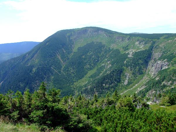
There were three glaciers of the alpine type in Pec pod Snezkou. The largest glacier in Krkonose began to slide down through Obri dul and like a giant bulldozer it formed the valley. So the valley is glacial, the witness is a U-shape profile (before glaciation, mountain valleys have a characteristic „V“ shape, produced by downward erosion by water. During glaciation, these valleys widen and deepen, which creates a „U“ shaped glacial valley. „Upsky“ glacier was 4 km length, 810 m high and its strength (axial length) was X m. It deposited rocks and earth along its sides and its front, creating mounds called moraine.
The summit area of the Giant Mts. (Krkonose) is a unique remote island of arctic and alpine tundra in Central Europe. Since the Glacial Period, its landforms, ground structures and treeless tundra communities are inhabited by plant and animal species surviving the short growing season in low temperature and wind-induced habitats, and tolerating freeze -and- thaw cicles under shallow snowpack.
(The informations are taken from KRNAP information boards and wikipedia)
If you want to log this cache, you have to complete two tasks:
1) send me (through my profile) an email with the answer of the question: What was the strenghth of „Upsky“ glacier? (number X at the information board) BE AWARE, during the winter the board is taken away, try to google the information.
2) take a picture of you at the coordinates and upload the image to your log (during the winter the path is closed due to the security reason, in this case use the additional waypoint and take a picture there)
CZ: Nejmene 5 ledovych obdobi trvalo i s teplejsim meziobdobim milion let. Poslední, nejslabsi doba ledova skoncila teprve pred deseti tisici lety. V dobe ledove vznikali ledovce - velke a pomaly se pohybujici reky ledu vzniknuteho zmrznutim kompaktnich bloku snehu a pohybujici se pusobenim gravitace.
V Peci pod Snezkou byly tri ledovce alpskeho typu. Nejvetsi krkonosky ledovec postupoval Obrim dolem a formoval ho jako velky buldozer. Udoli je tedy ladovcoveho puvodu, svedci o tom jeho profil ve tvaru pismene U (geologove rozlisuji 2 zakladni tvary U - modelovan ledovcem a V - modelovan rekou). Upsky ledovec mel delku az 4 km, sahal do vyse 810 m a mel mocnost (tloustku) az X m. Pri svém ustupu zanechal po sobe svedectvi ve forme tri morenovych valu. Morena je nahromadeny material, ktery ladovec pri svem stekani strhava, tlaci pred sebou (celni morena) nebo vytlacuje po stranach (bocni morena).
Hrebenova cast Krkonos je z prirodovedneho hladiska jedinecne uzemi ve stredni Evrope - predstavuje totiz izolovany ostrov arkto-alpinske tundry vzdalene 2000 km od nejblizsi tundry Skandinavie a 450 km od nejblizsich lokalit alpinske tundry Alp a Karpat. Tundra se zde zachovala od dob ledovych. Pro zdejsi krajinu je typicke drsne klima, mrazem, vetrem a snehem utvareny povrch, vyskyt tundrovych druhu rostlin a zivocichu a absence lesa.
(Informace pochazeji z informacnich tabuli KRNAP a wikipedie)
Pro uznani logu na tehle earthcache musite splnit 2 ukoly:
1) Poslat mi pres profil odpoved na nasledujici otazku:
Jaka byla mocnost Upskeho ledovce? (cislo X - udaj na informacni ceduli) POZOR, na zimu se cedule dava pryc, info si musite vygooglit.
2) odfotte se pri tabulce Obri dul na suradnicich a svou fotku pripojte k logu. Pozor, v zime je stezka pravdepodobne uzavrena z bezpecnostnich duvodu, v tomhle pripade pouzijte doplnujici souradnice (additional waypoint).