
El llac dels Pessons es troba situat a l'entrada del cercle glaciar dels Pessons a la cota 2300. És el primer llac d'una sèrie de llacs d'alta muntanya que podeu visitar recorrent el camí GR-7 que travessa el cercle. Hi ha diverses maneres d'arribar-hi. La més coneguda és, sense cap dubte, començant partint de l'estació d'esquí de Grau Roig que ara fa part del grup d'estacions Gran Valira.
Si teniu un vehicle tot terreny podeu pujar per la pista de terra fins al llac, on només haureu de caminar uns 10-15 minuts per trobar el caché.
Però si teniu un vehicle convencional, és millor aparcar-lo al darrer parking asfaltat de l'estació (encara que hem vist gent pujar amb berlines de luxe). A partir d'aquí haureu d'anar a peu per la pista. El recorregut fins el caché és d'uns 2000m i el desnivell de 200m.
Si teniu temps, una vegada trobat el caché, us aconsellem que continueu pel camí GR-7 a la recerca dels altres llacs, no quedareu decebuts. Penseu que us trobeu en alta muntanya i que heu d'anar ben calçats i abrigats. A l'hivern, només es pot arribar al caché amb raquetes o esquís de randonnée.
Si us ha agradat aquest multicaché, no dubteu en visitar un altre llac famós d'Andorra: el llac d'Engolasters (GCZRAC)
| WP1: |
|
N 42°31.821 |
| |
|
E 1°41.816 |
|

|
En aquest primer waypoint trobareu la sortida d'un telecadira.
ABCD = llargada del recorregut del telecadira. |
| WP2: |
|
N 42°31.564 |
| |
|
E 1°41.287 |
|
|
El segon waypoint us portarà davant d'un cartell de fusta.
EFGH = suma de les 3 altituds que es troben al cartell. |
| WP3: |
|
N 42°31.442 |
| |
|
E 1°41.346 |
|
|
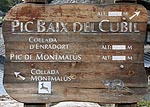
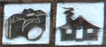
Finalment el tercer waypoint us portarà davant d'un altre cartell de fusta.
JKLM = suma de les altituds indicades per les dues icones de la foto. |
|
|
|
| El caché es troba a les coordenades següents:
N 42°31.(H)(C+4)(L-1)
E 1°41.(B)(M)(F)
Esperem que l'excursió us hagi agradat.
|
Aquí teniu un quadre que podeu utilitzar alhora d'apuntar els resultats de la recerca:
| WP1 |
WP2 |
WP3 |
| A |
B |
C |
D |
E |
F |
G |
H |
J |
K |
L |
M |
| |
|
|
|
|
|
|
|
|
|
|
|
The lake of the Pessons is located at the entrance of the glacier circle of the Pessons at 2300 m of altitude. It's the first lake of a series that you can visit following the GR-7 path that goes through the glacier circle. There is many ways to go. The most famous is, without any doubt, starting from the Grau Roig ski station. This ski station is now part of the big station group Gran Valira.
If you have an all-terrain vehicle, you can follow the earth track until the lake, where you will have to walk only 10-15 minutes to locate the final cache.
But if you have a street vehicle, you'd better park in the last parking of the station (although we have seen people climb to the lake with luxury cars). From there you will have to walk following the track. The distance to the cache is about 2000m with a difference of height of 200m.
If you have time, once the cache is located, we advise you to follow the GR-7 path to look for the other lakes, you won't be disappointed. Remember that you are in high mountains, so bring with you convenient boots and clothes as the weather can change very quickly. In winter, you can only reach the cache with special equipments for the snow.
If you liked this multicache, don't forget to visit another Andorran famous lake: the lake of Engolasters (GCZRAC)
| WP1: |
|
N 42°31.821 |
| |
|
E 1°41.816 |
|
|
At this waypoint you will find the start of a chair lift.
ABCD = total length of the chair lift route. |
| WP2: |
|
N 42°31.564 |
| |
|
E 1°41.287 |
|
|
The second waypoint will bring you in front of a wooden sign.
EFGH = sum of the 3 heights that are located on the sign. |
| WP3: |
|
N 42°31.442 |
| |
|
E 1°41.346 |
|
|
Finally, the third waypoint will bring you in front of another wooden sign.
JKLM = sum of the altitudes indicated for the icons you can see in the picture. |
|
|
|
| The cache is located at this coordinates:
N 42°31.(H)(C+4)(L-1)
E 1°41.(B)(M)(F)
We hope you enjoyed the hike.
|
Here you have a table that you can use to note the solution of the clues:
| WP1 |
WP2 |
WP3 |
| A |
B |
C |
D |
E |
F |
G |
H |
J |
K |
L |
M |
| |
|
|
|
|
|
|
|
|
|
|
|