The Pipes of
Baidhb:
Park at the
roadside car park beside the ruins of Tankardstown engine house
(N52 08.329 W07 20.640). Walk west along the road for about 400m.
At signs warning of unprotected mine shafts cross over the low wall
and follow path outwards and eventually down.
The Pipes Are Calling…
This EarthCache can be found
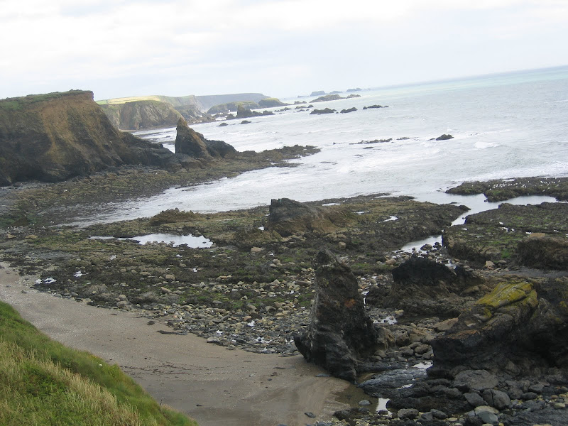
along a length of Waterford coastline known as the Copper Coast.
The Copper Coast extends between Tramore in the east, to Dungarvan
in the west, and comprises six local communities: Fenor, Dunhill,
Annestown, Boatstrand, Bunmahon and Stradbally. All are easily
accessible along the R675.
This coastline, is without
doubt, an outdoor geology museum with a geological heritage that
reflects a variety of environments under which the area has evolved
over the last 460 million years. Sedimentary and volcanic rocks
illustrate the closure of the Iapetus Ocean and subsequent
volcanism; the collision of two continents leading to the creation
of Ireland – as part of a desert dissected by large rivers;
and, finally, the effects of glaciation during the Ice Age.
Cross-sections of these are exposed along the spectacular cliffs
and interpreted for the public at various points.
Copper was mined extensively
in the area during the 19th Century. The Copper Coast icon is the
mine complex on a high point of the cliffs. This is the reference
point noted above (Tankardstown Engine House). In recognition of
its outstanding volcanic geology, as well as the very significant
history of mainly 19th Century copper mining; the region was
awarded the designations of "European Geopark" in 2001, and "UNESCO
Global Geopark" in 2004.
There are many wonderful examples of ancient geological processes
that could feature as an Earthcache, I have chosen the feature
known locally as the Pipes of Baidhb. (pronounced "bide").
According to legend the Baidhb, like the Beansidhe, was regularly
seen on the roads around Fenor. She was a ghost-like woman with a
long drawn face who drifted from place to place screeching at the
top of her voice. She was dressed in white and was very frightening
to see or hear. I've certainly never seen her!
Three other features can also be examined as you seek out the
pipes. Access to the beach is tricky enough and caution is advised
at full tide. It is advisable to check the tide times before you
visit and go at low tide. Don’t worry – the tide
won’t isolate you but just be mindful. When you gain access
to the beach after climbing down, look in the “corner”
where the headland meets the cliff. An excavation can be seen and
is easy to walk into. Note the green oxidised copper on the walls.
About 10m further on was a similar excavation which has recently
collapsed. It looks like a big pile of rubble now. Just by these
two features the cliffs are, for a short distance, are composed of
limestones. These banded and pale grey/buff coloured rocks reflect
a temporary respite from the vulcanism during the evolution of this
part of the coast line. They are about 455 million years old and if
you look closely at the vertical surfaces you can seen many
crescent shaped sections through fossil shells. These rocks, which
continue intermittently eastward from here all the way to Tramore
contain many fossils of different types, many now
extinct.
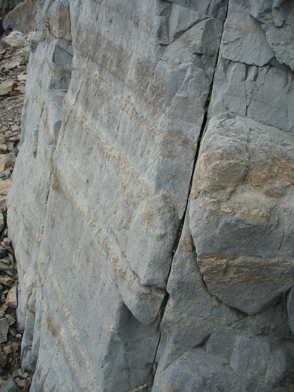
Fossil Layers in the Limestone
Continue up the beach towards
the co ordinates, The pipes appear as a colonnaded arch, an array
of angular columns sweeping up from the beach at the co ordinates
to the crest of the cliffs, and back down again about 150m further
east. This is the Giants Causeway of the Copper Coast although
formed here by a different rock, rather than basalt – can you
identify this rock? It is a volcanic rock, but a much more treacly
and silica rich than either basalt or andesite. It is generally
produced towards the end and far more explosive stages in the
evolutionary life cycle of a volcano. In this case, rather than
being erupted onto the surface, the rock has been injected in an
arch like form into mudstones. As it cooled, the columns developed
and grew inward at right angles to the rock – mudstone
contacted all the way around the arch, so forming the sweeping
colonnade in the cliffs.
The last feature which you
need to see in order to answer the logging questions is the Bawn
Ivy Lode, it can be found approx 180m further east along the beach.
In a shallow alcove, testimony to the tenacity of the miners of the
Copper Coast can be seen. A set of vertical adits (an adit is a
horizontal tunnel) mark the projection of the Bawn Ivy Lode on the
cliff face, each adit developed to test the lode at different
levels. How many adits can you see? Lodes like this were deposited
in fractures in the rocks when super hot, metal rich fluids, forced
their way through weak planes in the rock structure. These fluids
are derived from deep within the earth's crust. The super hot
fluids could also cause massive alteration of the rocks which
through they passed – now most obviously visible as a change
in colour of the original rock. Such an alteration zone or gossan,
to use a miner's term, are common around mine workings. Another
colonnade of columns is conspicuous in the mid – upper left
hand side of the cliff. Look into the lowest adit, those with eagle
eyes will see green and brilliant azure colouration of the rocks.
This is most probably green malachite and blue azurite.
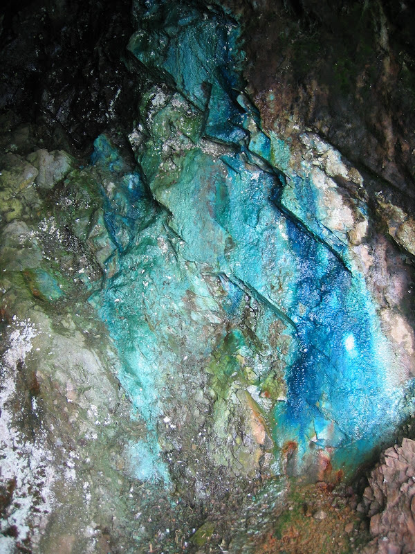
Malachite and Blue
Azurite
This is a tantalising glimpse
at what lay in the heart of these cliffs and is a reminder of the
men and women who strived to remove it.
To log your visit please
e-mail me through my profile the following
information:
(a) How many windows are in
the west-facing wall of the Tankardstown Engine
House?
(b) What rock type are the
Pipes of Baidhb formed from?
(c) How many vertical adits
are visible at the Bawn Ivy Lode?
It would also be great to
have a photograph of yourself with your GPS in front of the Pipes -
although this is not a logging
requirement.
There is much, much more
heritage associated with this area and I have only scrapped the
surface. There are some information boards near the engine house
but some further on line research may be needed. I hope I piqued
your
interest!
Safety - Note 4 ****
Terrain: The access to the pipes is tricky. Three things to
keep in
mind:
(1) There are open mine
shafts around, most of them are fenced off and common sense says -
Do not fall down one!!
(2) The scramble down to
beach level can be slippy in the wet, please take your
time.
(3) There is a small window
whereby the high tide will prevent acess to the site or may cut you
off on the way back, please use common sense and the following tide
times: here.
Dungarvan Habour times will be good
enough.