From the guidelines, as from January 2013"People do not need to wait for permission to log your EarthCache. Requiring someone to wait is not supported by the EarthCache guidelines. People should send their logging task answers to you, then log your EarthCache. When you review their logging task answers, if there is a problem, you should contact them to resolve it. If there is no problem, then their log simply stands."

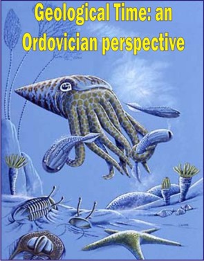
The Ordovician Period
Naming: The Ordovician, named after the Welsh tribe of the Ordovices, was defined by Charles Lapworth in 1879, to resolve a dispute between followers of Adam Sedgwick and Roderick Murchison, who were placing the same rock beds in northern Wales into the Cambrian and Silurian periods respectively. Lapworth, recognizing that the fossil fauna in the disputed strata were different from those of either the Cambrian or the Silurian periods, realized that they should be placed in a period of their own.
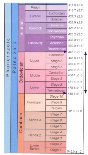 Time scale: The International Commission on Stratigraphy now accepts the Ordovician period to span between 488 ±1.7 Ma and 443 ±1.5 Ma. This is, in the geological time scale, sandwiched in between the lower, Cambrian and upper, Silurian periods.
Palaeogeography: Sea levels were high during the Ordovician; in fact during the Tremadocian, marine transgressions worldwide were the greatest for which evidence is preserved in the rocks.
During the Ordovician, the southern continents were collected into a single continent called Gondwana. Gondwana started the period in equatorial latitudes and, as the period progressed, drifted toward the South Pole. Early in the Ordovician, the continents Laurentia, Siberia, and Baltica were still independent continents (since the break-up of the supercontinent Pannotia earlier), but Baltica began to move towards Laurentia later in the period, causing the Iapetus Ocean to shrink between them. Also, Avalonia broke free from Gondwana and began to head north towards Laurentia. Rheic Ocean was formed as a result of this.
The Early Ordovician was thought to be quite warm, at least in the tropics. As with North America and Europe, Gondwana was largely covered with shallow seas during the Ordovician. Shallow clear waters over continental shelves encouraged the growth of organisms that deposit calcium carbonates in their shells and hard parts. Panthalassic Ocean covered much of the northern hemisphere, and other minor oceans included Proto-Tethys, Paleo-Tethys, Khanty Ocean which was closed off by the Late Ordovician, Iapetus Ocean, and the new Rheic Ocean.
Ordovician rocks are chiefly sedimentary. Because of the restricted area and low elevation of solid land, which set limits to erosion, marine sediments that make up a large part of the Ordovician system consist chiefly of limestone. Shale and sandstone are less conspicuous.
By the end of the period, Gondwana had neared or approached the pole and was largely glaciated.
Life: Though less famous than the Cambrian explosion, the Ordovician featured an adaptive radiation that was no less remarkable; marine faunal genera increased fourfold, resulting in 12% of all known Phanerozoic marine fauna. The trilobite, inarticulate brachiopod, archaeocyathid, and eocrinoid faunas of the Cambrian were succeeded by those which would dominate for the rest of the Paleozoic, such as articulate brachiopods, cephalopods, and crinoids; articulate brachiopods, in particular, largely replaced trilobites in shelf communities. Their success epitomizes the greatly increased diversity of carbonate shell-secreting organisms in the Ordovician compared to the Cambrian.
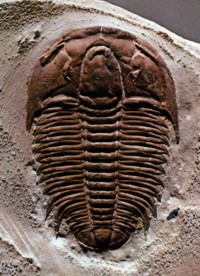 In North America and Europe, the Ordovician was a time of shallow continental seas rich in life. Trilobites and brachiopods in particular were rich and diverse. The first bryozoa appeared in the Ordovician as did the first coral reefs. Solitary corals date back to at least the Cambrian. Molluscs, which had also appeared during the Cambrian, became common and varied, especially bivalves, gastropods, and nautiloid cephalopods. It was long thought that the first true vertebrates (fish - Ostracoderms) appeared in the Ordovician, but recent discoveries in China reveal that they probably originated in the Early Cambrian. The very first jawed fish appeared in the Late Ordovician epoch. Now-extinct marine animals called graptolites thrived in the oceans. Some cystoids and crinoids appeared.
In Portugal: The Ordovician age rocks in Portugal are distributed in thin slivers throughout the country (see map) and are denoted in the geological maps by a vibrant, dark green colour. Typically they consist of a basal conglomerate followed by decametric beds of white vitreous quartzite (The Armorican Quartzite Formation), which are then overlain with a set of metapelitic sediments.
In places, such as Penha Garcia, Vila Velha de Ródão and Valongo these rocks are exposed as large synclines or anticlines with secondary folds within.

Claiming the cache:
This cache will take you to Barrancos in SE Portugal to a place called Pipa. Here there is a water spring next to the Murtéga river. You can bring a towel and swimming trunks and have a nice dip in the water. You will also be face to face with a sliver of Ordovician aged rocks: Quartzites that exhibit a particular habit as well as ripple marks (fossilised waveves on the rock surface). What I need you to do in order to claim this earthcache is to tell me the azimuth of the dip of the rock strata, i.e. the direction of dip . If you're having troubble deciding what that is, then have a look at this cache . Do not place the answers in the log. Enjoy!
A cache:
As coordenadas desta cache levam-te a para Barrancos ao lugar da Pipa, uma fonte adjacente à Ribeira da Murtéga. O sítio é optimo para poderes tomar banho portanto vem preparado com a tolha (acho que o uso de fato de banho não é opcional), patinho de borracha, bóias, escafandro e o resto da tralha. Neste local irás deparar com quatzitos do Ordovícico que além tempos já estiveram debaixo de água e por isso apresentam na sua superfície vestigios da ondulação que originou a sua deposição. Os estratos destes quartzitos estão orientados de uma forma bastante marcante e para logares o found, preciso que me envies um mail com o azimute dessa orientação ou seja a direcção de pendor. Se isto é tudo chinês, sugiro que passes uns minutos a ler as descrições apresentadas no seguinte link. Mandem-me um mail com resposta e não coloquem fotos spoiler dos quartzitos.
Happy earthcaching!
 The most exciting way to learn about the Earth and its processes is to get into the outdoors and experience it first-hand. Visiting an Earthcache is a great outdoor activity the whole family can enjoy. An Earthcache is a special place that people can visit to learn about a unique geoscience feature or aspect of our Earth. Earthcaches include a set of educational notes and the details about where to find the location (latitude and longitude). Visitors to Earthcaches can see how our planet has been shaped by geological processes, how we manage the resources and how scientists gather evidence to learn about the Earth. To find out more click HERE.

______________________________________________________________________________