
[CZ]
Travertinová
kaskáda
Tento význacný chránený prírodní výtvor se nachází na katastrálním
území obce Tichá. Tvorí jej vydatný sladkovodní pramen, který je
pravým prítokem rícky Tichavky. Vyverá na jihozápadním úbocí
Tichavy (Tichavské hurky) ve výšce asi 370 m. n .m., jejíž jižní
cást tvorí vápenec. Podle vyprávení starých obcanu prý jsou v
podzemí trhliny, snad i jeskyne, kde se drží hladina vody, která
práve zde vyverá a vápenec se usazuje na tráve, mechu a okolo toku
a tím se stále koryto potucku zvyšuje.
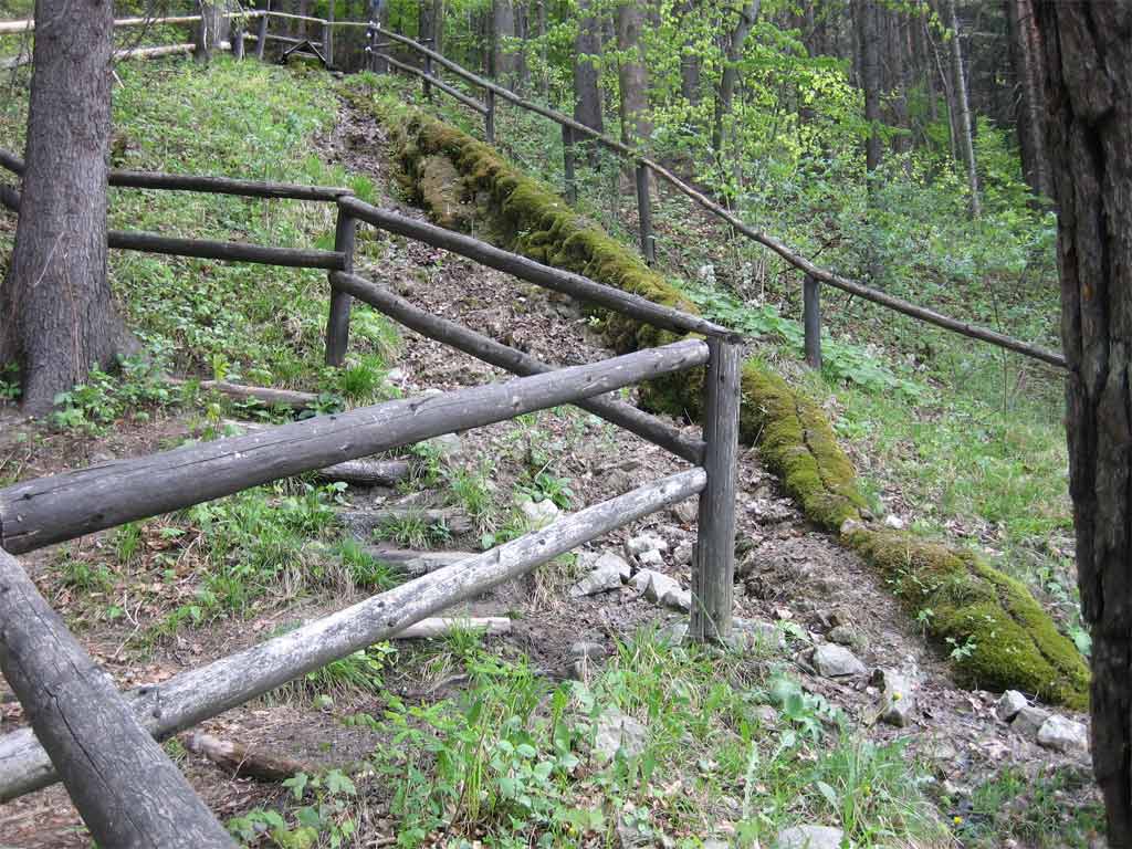
Délka takto vzniklého potucku je cca 120 m, po celé délce nepribírá
žádný prítok. Potucek vytvárí recentní travertinovou kaskádu
výrazne vyvýšenou nad okolní terén. Podloží potucku je tvoreno
travertinovým valem o výšce 10 - 70 cm. Ve vrcholové cásti valu je
vyerodováno melké koryto, hluboké 5 - 10 cm a o stejné šírce. Ve
své horní cásti protéká potucek lesem. Pres velkou rychlost tekoucí
vody jsou práve v techto místech nanášeny travertinové kaskády
nejvetší mocnosti. V druhé polovine toku se vinul potucek po okraji
louky, po povodních v roce 1997 však došlo k sesuvu okolních brehu
a byla porušena i dolní cást potucku.
Vzhledem k tomu, že výše popsaný útvar je jediným svého druhu v
okrese Nový Jicín, je chránen zákonem c. 40/1956 Sb. o státní
ochrane prírody a byl vyhlášen dnem 1. 7. 1988 chráneným prírodním
výtvorem “TRAVERTINOVÁ KASKÁDA”.
Útvar se nachází na bežne prístupném verejném prostranství.
Nevybírá se zde žádné vstupné
K uznání logu je
treba:
1.odeslat svoji fotku
v blízkosti výveru pramene (u osamnelych lovcu staci vase GPS
s pozadim
vyveru )
2. Zodpovedet následující tri
otázky:
2.1.Jaké základní
chemické složení má travertin
?
2.2.Jak dlouho se
tvorila uvedená travertinová kaskáda (staci
radove)?
2.3.Jak se jmenují
jedny z nejvetších travertinových kaskád v Evrope,
pripadne v blizke Asii
?
[ENG]
Travertine
cascade
This distinguished protected natural creation is on cadastral
municipal territory in the village of Ticha. It has formed a
productive freshwater well, that is an inflow stream named
Tichavka.
It rises on the southwest hill - side Tichavy (Tichav barnchamber)
- in altitude of about 370 m. n .m., along the south side calcite
forms. According to old residents it is said there are
underground cracks, maybe caves, where water is held. This water
rises and calcite precipitates on the grass and moss and around the
flow rivulets increase.
Longitude of this postneuritic rill is about 120 m and
throughout there is no one inflow. The rill creates recent
travertine marble cascades above the neighbouring terrain.
Subsoil rill is formed in the travertine marble space at about an
altitude of 10 - 70 cm. In the top parts there is an eroded
shallow trough which is 5 - 10 cm deep and about the same
width. In its upper parts it traverses the rill through the
forest. Above there are large rate flowing waters and in
these quarters aggradation travertine marble has a wide
thickness. In the second half of the flow the rivulet ended
up near edge meadows and after a water flood in the year 1997,
getting to the surrounding banks and bottom rill was
difficult.
Appearance of the above described formation is only one in the
district of Novy Jicin and it is protected by law. It was
noted 1. 7. in 1988 as a protected natural creation, the
"TRAVERTINOVA KASKADA".
To log this EarthCache you must:
1.Take a photo near the introduced
well
2.Answer the next three
questions:
2.1. What is the
basic chemical constitution of travertine ?
2.2 How
long did it take the travertine marble cascade to
form?
2.3 What is the
name the biggest travertine marble cascade in Europe
?
* * *
Special thanks Hurvi for tip and Geoware for english text
correction
* * *
|
FTF |
|
|
martmali
|
|
|
STF |
|
TTF |
Grako
|
|
MarcanC
|