
 The tar pits and oil seeps in Carpinteria are part of a
series of oil producing areas along the Ventura and Santa
Barbara Coast. Oil has naturally migrated to the surface in
this area creating oil seeps, asphaltium, and at one time tar
pits.
The tar pits and oil seeps in Carpinteria are part of a
series of oil producing areas along the Ventura and Santa
Barbara Coast. Oil has naturally migrated to the surface in
this area creating oil seeps, asphaltium, and at one time tar
pits.
This earthcache is at the city of Carpinteria’s Tar Pits Park.
From Carpinteria Avenue, take Concha Loma Avenue to Calle Ocho;
park at the end of Calle Ocho and walk across the railroad tracks
to the lookout point. This is an unsigned crossing, so carefully
check the tracks before crossing. A signed crossing is available to
the west on Palm Avenue near the entrance to the State Beach.
The rocks beneath this area are the Miocene Monterey Formation.
The Monterey Formation is common along the coast of California. In
fact, similar rocks were deposited throughout the Pacific Rim
during the Miocene (17.5 to 6 million years ago). All of these
rocks share similar characteristics. They are Diatomaceous (made up
of the shells of microscopic plankton called diatoms) Phosphatic
(containing phosphate) Dolomitic (containing dolomine); and Rich in
organic matter (oil and gas)
This last characteristic, being rich in organic matter, makes
these rocks economically important because they often are
reservoirs for oil and gas. Most of the off-shore oil rigs along
the California coast pump oil from this formation. Across the
Pacific, Japan has similar rocks and oil reserves.
In this area, the oil has found natural paths to the surface. In
the Pleistocene, tar pits similar to the La Brea Tar Pits existed
in the area. Scientific excavations have recovered a collection of
fossils that rivals the Rancho La Brea (earthcache hyperlink)
collection. The collection includes mammal, bird, insect, and
marine invertebrate remains. Birds are the most common animal found
with over 57 different species including the California Condor and
Golden Eagle
Unlike the collection from La Brea, a large number of fossil
plants have been collected from Carpinteria. Ferns, redwoods,
pines, and oaks are among the plant fossils. Some of these species
require a cooler and moister climate than what is currently found
in Southern California indicating that at some time during the
Pleistocene, the climate of Southern California was not as hot and
was wetter.
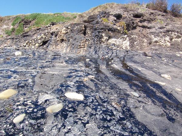 Today you specimens are continuing to be
trapped in the tar. Sea shells and rocks are being covered in
the seeping tar. In other areas where the oil continues to
seep from cliffs, wave rounded rocks, seaweed, and shells
continue to be trapped in the sticky tar.
Today you specimens are continuing to be
trapped in the tar. Sea shells and rocks are being covered in
the seeping tar. In other areas where the oil continues to
seep from cliffs, wave rounded rocks, seaweed, and shells
continue to be trapped in the sticky tar.
These tar deposits were used by the Native Americans for
waterproofing. In the 1920s, these pits were mined for road
building. Then the open pits were used as a dump.
Logging requirements:
Send me a note with :
- The text "GC127EG Tar Pits Park" (or something similar) on the
first line
- The number of people in your group.
- Examine the tar deposit at the coordinates or along the city
beach to the east and locate something stuck in one of the seeps
other than the large rocks . If you can upload a photograph of what
you found.
- Post in your log, the air temperature and the stiffness of the
tar. You may want to use something disposable for this task.
- Send me a note with the difference between the tar that had
recently seeped out of the ground and the tar that has been on the
beach for a while. Include what you think would account for the
difference.
Thanks to the City of Carpinteria’s Parks and Recreation
Department for allowing the placement of this Earthcache.
The above information was compiled from the
following sources:
- Richard J. Behl California State University,
Long Beach, Monterey Formation,
http://seis.natsci.csulb.edu/rbehl/Mont.htm
- HARTMAN MULTIMEDIA Carpinteria Asphalt Deposits
http://www.californiawildflowers.info/Santa%20Barbara%20County/carpinteria_asphalt_deposits.htm
- Ventura Basin: Geologic Introduction and Field
Trip Guidebook, Martin H. Link Editor, The Pacific Section American
Association of Petroleum Geologists, Los Angeles, California and
Los Angels Basin Geologic Society, April 16, 1988
.