Glacial Lake Iroquois was a prehistoric proglacial lake that
existed at the end of the last ice age approximately 13,000 years
ago. The lake was essentially an enlargement of the present Lake
Ontario that formed because the St. Lawrence River downstream from
the lake was blocked by the ice sheet near the present Thousand
Islands. The level of the lake was approximately 30 m (~100 ft)
above the present level of Lake Ontario.
The Lake drained to the southeast, through a channel passing
near present day Rome, New York. The channel then followed the
valley of the Mohawk River to the Hudson River.
The Lake was fed by Early Lake Erie, as well as Glacial Lake
Algonquin, an early partial manifestation of Lake Huron, that
drained directly to Lake Iroquois across southern Ontario, along
the southern edge of the ice sheet, bypassing Early Lake Erie.
The subsequent melting of the ice dam resulted in a sudden
lowering of the lake to its present level, and setting off the
Younger Dryas episode.
The prehistoric shoreline, marked by a ridge known as the
Iroquois Shoreline, can be discerned in places around Lake Ontario.
This can be seen, for instance, in Toronto paralleling Davenport
Road near Spadina Avenue, and also nearby in Scarborough, Ontario,
where the prehistoric shoreline takes the form of earthen cliffs at
the modern lakeshore (called the Scarborough Bluffs).
The lake was carved out of soft, weak Silurian rocks by the
Wisconsonian ice age glacier, which expanded the preglacial
Ontarian River valley of approximately the same orientation. The
material that was pushed southward was piled in central and western
New York in the form of drumlins, kames, and moraines, which
reorganized entire drainage systems. As the glacier retreated from
New York, it still dammed the present St. Lawrence valley, so that
the lake was at a higher level. This state is known as Lake
Iroquois. During that time the lake drained through present-day
Syracuse, New York into the Mohawk River. The old shoreline that
was created during this lake stage can be easily recognized by the
(now dry) beaches and wave-cut hills 10 to 25 miles (15 to 40 km)
south of the present shoreline.
When the glacier finally melted from the St. Lawrence valley,
the outlet was below sea level, and the lake became for a short
time a bay of the ocean. Gradually the land rebounded from the
release of the weight of about 6,500 feet (2000 m) of ice that had
been stacked on it. It is still rebounding about 12 inches (30 cm)
per century in the St. Lawrence area. Since the ice left that area
last, that is the area where the most rapid rebound still is
occurring. This means that the lake bed is gradually tilting
southward, inundating the south shore and turning river valleys
into bays. Both north and south shores have shoreline erosion, but
the tilting amplifies this effect on the south shore, causing loss
to property owners.
The Wisconsin or Wisconsinian was the last major advance of
continental glaciers in North America. This glaciation is made of
three glacial maximums (commonly called ice ages) separated by
interglacial periods (such as the one we are living in). These ice
ages are called (from oldest to youngest); Tahoe, Tenaya and Tioga.
The Tahoe reached its maximum extent perhaps about 70,000 years
ago. Little is known about the Tenaya. The Tioga was the least
severe and last of the Wisconsinan group. It began about 30,000
years ago, reached its greatest advance 20,000 years ago, and ended
about 10,000 years ago. At the height of glaciation the Bering land
bridge permitted migration of mammals and humans to North America
from Siberia
.
It radically altered the geography of North America north of the
Ohio River. At the height of the Wisconsin glaciation, ice covered
most of Canada, the Upper Midwest, and New England, as well as
parts of Montana and Washington. On Kelleys Island in Lake Erie or
in New York's Central Park, the grooves left by these glaciers can
be easily observed. In southwestern Saskatchewan and southeastern
Alberta a suture zone between the Laurentide and Cordilleran ice
sheets formed the Cypress Hills, which is the northernmost point in
North America that remained south of the continental ice
sheets.
The Great Lakes are the result of glacial scour and pooling of
meltwater at the rim of the receding ice. When the enormous mass of
the continental ice sheet retreated, the Great Lakes began
gradually moving south due to isostatic rebound of the north shore.
Niagara Falls is also a product of the glaciation, as is the course
of the Ohio River, which largely supplanted the prior Teays
River.
In its retreat, the Wisconsin glaciation left terminal moraines
that form Long Island, Nantucket and Cape Cod, and the Oak Ridges
Moraine in south central Ontario, Canada. The drumlins and eskers
formed at its melting edge are landmarks of the Lower Connecticut
River Valley.
During the final retreat of the Laurentide Ice Sheet, ice
blocked the St. Lawrence valley causing meltwater to flood the Lake
Ontario basin and create glacial Lake Iroquois. Distinctive
features of the Lake Iroquois shoreline are its prominent
shorebluff, and large sand and gravel bars deposited in the Don and
Humber river valleys. Downtown Toronto was submerged and is built
on the old lake bottom. The Lake Iroquois shoreline also forms the
headwaters for smaller streams such as Petticoat and Highland
creeks. Sand and gravel deposited along the shore of Lake Iroquois
were mined for construction and clay from the former lake bottom
was used to make bricks.
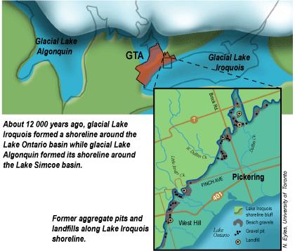
About 12 000 years ago, glacial Lake Iroquois formed a shoreline
around the Lake Ontario basin while glacial Lake Algonquin formed
its shoreline around the Lake Simcoe basin.
Former aggregate pits and landfills along Lake Iroquois
shoreline.
Historically, the natural shore of Lake Ontario was at Front
Street. Since the 1850s the Toronto shoreline has been extended
almost 1 kilometre into the harbour by dumping millions of tonnes
of fill. This originally provided land for industry and shipping.
Now this land is used for condominiums, hotels, and parks. More
recently, filling has occurred to reduce shoreline erosion and to
build parks and marinas such as Bluffer's Park and Ontario
Place.
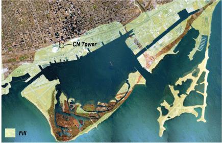
Filling since 1850 has created lots of new land in the Toronto
harbour area.
Some time between thirteen and twelve thousand years ago, the
ice disappeared from the Lake Ontario basin and the lake waters
which had had to use southern and western outlets at a higher
level, found an outlet into the Hudson River near Rome, New York.
As this was higher than today's St. Lawrence outlet, a high level
lake we know as Lake Iroquois formed.
The crustal block that underlies most of The Province of Quebec
and north-eastern Ontario,together with the eastern end of Lake
Ontario and the St. Lawrence valley had been under as much as 2 km
of ice for over 100,000 years and thus had been pushed hundreds on
metres down into the mantle. The western end of the lake was freed
from the ice several thousand years earlier than the eastern end,
and probably had only been under the ice sheet for a small part of
the Wisconsinan iceage. As a result it rebounded first, tilting
that end of the Lake Ontario basin up at the time of Lake Iroquois
(and for some time after). The eastern end of Lake Ontario and the
St. Lawrence valley, having been depressed more, have rebounded
more; thus the present in level of the Lake Iroquois shoreline
varies from 55 metres above sea level near the Humber to 68 metres
at the east end of Scarborough.
Into that cold glacial lake flowed a number of streams which are
now tributaries of the Don River, including Castle Frank Brook,
Yellow Creek and Mud Creek. See above map of the Toronto shoreline
12,000 years ago. All of downtown below Davenport Road was under
the icy waters of Lake Iroquois. Much of Leaside was covered by a
shallow bay, some times referred to as a lagoon, because it was cut
off from the lake by a sand bar along today's Danforth Ave.
For the last two million years or so, large parts of the
northern hemisphere, all of Antarctica and many mountain chains on
other continents have been covered and recovered by ice sheets. The
surface of most of Canada has been shaped by the advancing and
retreating of these glaciers. Most of Great Lakes' basins of and
other Canadian lakes both large and small were carved out by the
moving ice. Soil and rocks were scooped off the Canadian Shield and
deposited over southern parts such as Toronto.
Many causes have been suggested for the Pleistocene Glaciation and
others earlier in our planet's history including: changes in solar
flux; changes in the shape of Earth's orbit & the tilt its
axis; the massing of the continents and deep oceanic currents.
Probably it was a combination of several such influences.
North America's continental ice sheet apparently started in
Labrador or Ungava then spread south in the east and west in the
north. Other ice sheets grew from the coalescing of mountain
glaciers in the west and in the Arctic. We may be closer to new
continental ice sheets than we think. There are many such ice
fields in that area. What would it take for these small ice fields
to join and grow into a glacier covering Labrador and Quebec?
Whenever a combination of cold climate and sufficient precipitation
in the form of snow occurs, as it has several times in the past few
million years and in the more distant past, continental glaciers
form and grow.
To log this earthcache you will need to complete the
following.
1.Take a picture of yourself with the Lake in the background and
post it with your log.
2.Measure the elevation of the lake and email it to me, how do you
think the elevation has changed in the past 100 years?