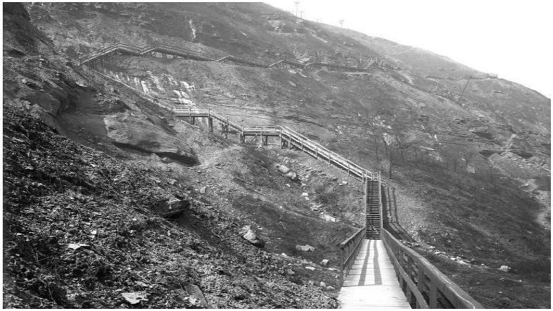
From the early 1900's to until they were dismantled in 1935, a
public wooden stairway of about 1000 steps allowed pedestrians to
reach Mount Washington from river level. Called Indian Trail,
probably following an existing trail, they started near the
Duquesne Incline, went westward, and after a switchback in a steep
section, they reached Duquesne Heights at the intersection of
Grandview Avenue and Shaler St.
Some of the original wooden posts¹ can still be found. They are
about three feet high, and come in pairs, about two feet apart.
From top to bottom, they can be found at (1) 40º 26.410N 80º
01.332W, (2) 40º 26.409N 80º 01.299W, (3) 40º 26.396N 80º 01.278W,
(4) 40º 26.392N 80º 01.230W, (5) 40º 26.393N 80º 01.206. Where the
steps switch-backed, there are signs of a relatively recent
landslide, the area is recognizable by being clear of vegetation,
and boulders and debris on the bottom of a steep section where it
flattens a bit to a grassy clearing. If following the coordinates
of the wooden posts listed above, you will encounter the landslide
right that after the last set of coordinates, making the expected
path non-transitable. One must return to the post 4 coordinates,
and from there, descend below and find a narrow ledge between two
small cliffs, at 40º 26.402N, 80º 01.215W ("Moon's Passage").
There is a tentative idea/plan of placing a couple hundred night
sticks along where the steps used to be for an upcoming Light-Up
Night to celebrate this now-gone feature that is characteristically
Pittsburgh
Terrain is difficult, and this cache should only be attempted by
expert hikers/walkers wearing footwear with strong traction.
Weather and wet conditions may increase terrain difficulty.
Do NOT cross the rail tracks along Carson Street. You may be
tempted in starting the hike from below. Crossing active rail
tracks is dangerous and unlawful. You must start your hike from the
top, at Grandview Ave and Augusta St intersection.
Start location is the same for a nearby micro cache, Take the
High Road. There is a grassy clearing off Grandview Avenue where
often many wedding photographs are made, and a small trail begins
on the western edge of it, at 40º 26.404N 80º 01.338W.
Duquesne
Incline
Other images of
Historic Pittsburgh digital library.
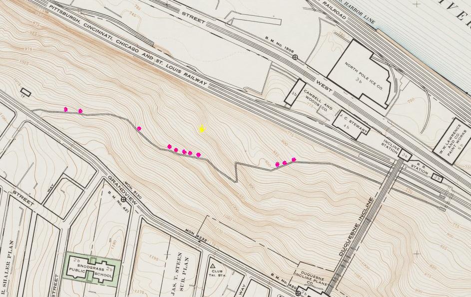
¹ Pink dots on map show where some of the
remaining posts are located. Yellow dot indicates the general
location of "Moon's Passage"