Bell-lloc Multi-cache
-
Difficulty:
-

-
Terrain:
-
Size:  (regular)
Please note Use of geocaching.com services is subject to the terms and conditions
in our disclaimer.
 Català
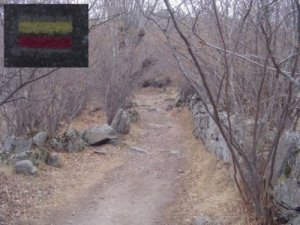
Multi-cache molt senzillet, que és recórrer un camí que va des del
poble de Dorres, fins a dalt d'un turó.
Gran història guarda aquest turó. Actualment, al cim es pot
apreciar el Santuari de Bell-lloc (format per una església romànica
del segle XII i restes d'un monestir), la Font dels Peregrins
(curiosament enterrada sota terra, al costat de l'església), i fins
hi tot restes d'un fracassat intent de muntar un important
observatori astronòmic, d'on ara només en queden els
fonaments.
A l'hivern, és molt provable trobar neu pel camí, per tant, s'ha de
tenir una mica de precaució.

Waypoint 1: El camí comença a N 42º 29.062' E 1º
55.979', on es pot trobar una placa metàl·lica en una pedra
vertical (mirar
imatge) d'on es podrà trobar el número Y, que servirà
per trobar el segon waypoint.
Un cop anotat el número Y, ara s'ha de calcular:
a = Y - 2
b = Y + 2
c = Y
d = Y
N 42º 29.ab2'
E 001º 55.cd4'
Ara s'ha de seguir el camí, seguint el PR (marques de pintura
vermella i groga) direcció Coll de Jovell (Coll de
Juell).
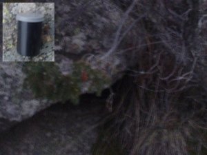
Waypoint 2: Ara s'ha de buscar un pot petit (de carret de
fotos) on hi ha les coordenades del cache final.
Waypoint final: Està a la zona de dalt del turó.
 Française
Multi-cache très facile, il consiste à parcourir un chemin qui va
du village de «Dorres» jusqu’en haut d’une
colline.
Cette colline garde une grande histoire, actuellement, dès le
sommet de la colline vous pouvez apprécier le sanctuaire de
Bell-lloc qui est formé par une église romaine du XIIe siècle et
des restes d’un monastère, vous pouvez aussi observer la
Fontaine des «peregrins» ( qui est curieusement enterrée sous
terre, à côté de l’église), et en plus vous pouvez trouver
des restes d'une tentative de construire un observatoire
astronomique très important qui a été ratée, où maintenant
seulement il y a les fondements.
En hiver, il est très probable de trouver de la neige, pour cette
raison, il faut faire attention.
Waypoint 1: Le chemin commence au N 42º 29.062' E 1º
55.979', où vous pouvez trouver une plaque métallique en une
pierre verticale (voir
image) et aussi où vous trouverez le numéro Y qui sert à
trouver le deuxième waypoint.
Une fois vous aurez noté le numéro Y, vous devrez
calculer:
a = Y - 2
b = Y + 2
c = Y
d = Y
N 42º 29.ab2'
E 001º 55.cd4'
Maintenant il faut suivre le chemin PR ( marques de peinture rouge
et jaune) en direction «Coll de Jovell» (Coll de Juell).
Waypoint 2: Maintenant il faut chercher un rouleau de photos
où vous trouverez les cordonnées du cache final.
Waypoint final: Vous êtes dans la zone d’en haut de la
colline.
 English
Very simple multi-cache, which consists on follow a way that goes
from the village of Dorres, until the above of a hill.
Great story keeps this hill. Currently, in the peak there can be
appreciated the Sancturay of Bell-lloc (formed by a Romanesque
church of the 12th century and rests of a monastery), the Font dels
Peregrins, (curiously buried underground, behind the church), and
even rests of an unsuccessful attempt to assemble an important
astronomical observatory, where now there only are the
foundations.
In winter, it's very provable to find a snow on the way, therefore
people have to go there with precaution.
Waypoint 1: The way starts in N 42º 29.062' E 1º
55.979', where there is a metallic plaque in a vertical stone
(look at the
image). In this plaque, you will view the Y number,
which will be necessary to access to the second waypoint.
Now, you have to calculate:
a = Y - 2
b = Y + 2
c = Y
d = Y
N 42º 29.ab2'
E 001º 55.cd4'
Then, you have to follow the PR way (marks of red and yellow paint)
in direction to Coll de Jovell (Coll de Juell).
Waypoint 2: Here you will have to search a small jar (of
black rollfilm of photos) where there are the coordinates of the
final cache.
Final waypoint: The cache is in the zone on the top of the
hill.
Additional Hints
(Decrypt)
[Català] - Ry pnpur rfgà ora erfthneqng ra han rfpyrgkn q'han ebpn.
[Française] - Yr pnpur rfg ovra cebgété ra har sragr q'har ebpur.
[English] - Gur pnpur vf irel xrrc vagb n ebpx svffher.