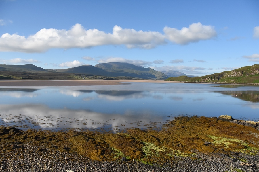
There's nothing quite like the freedom of the long open road. Never-ending back roads, wide meandering country tracks and beautiful bends through some of Scotland's finest coastal scenery are just a few things you can expect along the North Coast 500 Virtual.
The North Coast 500:
More than 500 miles of the best the North Highlands has to offer. The route starts in the northern city of Inverness, weaves along the west coast to Applecross and then northwards towards the bustling towns of Torridon and Ullapool. From there, you'll venture to some of the most northerly coastal points in Scotland, passing by Caithness and John o'Groats before heading south again through Dingwall and finally back to Inverness.
In order to claim this virtual cache, you must visit each of the four locations and send me the answers to the questions and include a photo of you or your GPSr at each of the waypoints (please don't post any spoilers). Logs without answers and photos being submitted will be deleted. You don't have to wait for confirmation of the answers, I will contact you if there are any problems.
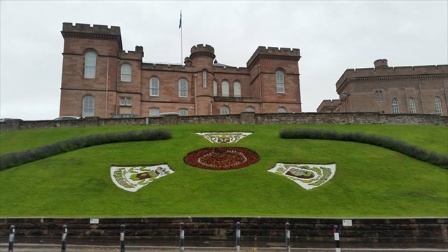
Stage 1 – Inverness Castle (N57 28.560 W4 13.535)
Inverness Castle is right in the heart of Inverness city overlooking the River Ness. It is the official start of the NC500, though if you’re looking for a big sign, or even a small sign, you’ll be disappointed.
The red sandstone structure evident today was built in 1836 by architect William Burn. It is built on the site of an 11th-century defensive structure. The castle itself is not currently open to the public, however the castle grounds and the North tower are open to the public.
Question 1 - The waypoint takes you to a statue. There is a quote on the plaque. Who is the person who made the quote? EDIT - whilst rennovations are in progress, please take a photo as close to the castle/statue as the barriers permit. No need to answer this question.
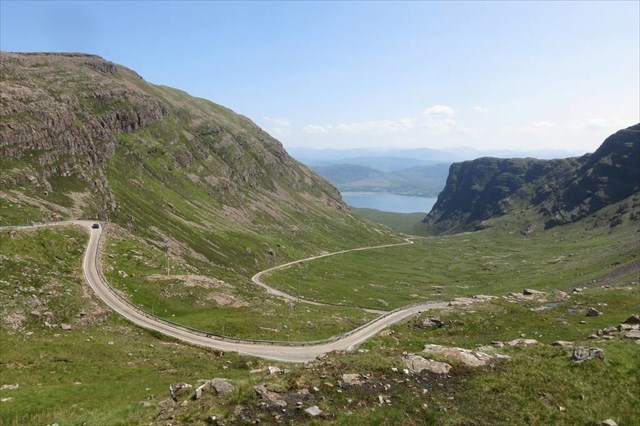
Stage 2 – Bealach na Ba (N57 25.126 W5 42.523)
The Bealach na Ba ("Pass of the cattle") is a winding, single track road through the mountains of the Applecross peninsula, in Wester Ross in the Scottish Highlands. The historic mountain pass is engineered similarly to roads through the great mountain passes in the Alps, with very tight hairpin bends that switch back and forth up the hillside and gradients that approach 20%. It boasts the steepest ascent of any road climb in the UK, rising from sea level at Applecross to 626 metres (2,054 ft), and is the third highest road in Scotland. You will NOT forget this drive as long as you live!
If you have a caravan in tow, or are driving a large motorhome, you might want to think twice at this point. It only takes ONE person who is not used to driving a large vehicle to block the road completely to the detriment of other users, those that use the road for work, and more importantly – emergency vehicles. The pass is also likely to be impassable during winter conditions.
Having enjoyed the drive up, and assuming the weather is clear, there is a parking area at the top with superb views across to Skye and the Outer Hebrides - Skye, Rum, Raasay, Rona, Harris, and Lewis stretch out before you. If that's not enough, it is possible to walk a few hundred metres back from the parking area, and then left up a track that leads up to a transmitter station. The view gets better and better as you go.......
Question 2 - The waypoint takes you to the viewpoint. What is the furthest distance away, and how far is it?
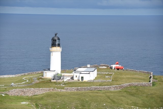
Stage 3 – Cape Wrath (N58 37.515 W4 59.934)
This route goes right out to the furthest North West point of the British mainland – a dramatic headland with its whitewashed lighthouse perched atop the cliffs. The road itself is not connected to the main public road network so access is by the Cape Wrath Ferry, a foot passenger boat from Keoldale, a mile South of Durness (make sure you arrange a return time as there’s no other way back). At the time of writing, a return Adult ticket (payable in cash only) is £7 and runs 7 days per week May to September. Places are limited and on a first come first served basis.
Note: Bikes and folded buggies can be taken on the ferry.
Once off the boat the way is obvious – there is only one road which continues for 11 miles to the lighthouse. The road is tarmac but fairly broken in places so the surface can be quite rough. After a short section parallel to the Kyle of Durness which gives wonderful views across to Balnakiel Bay the road swings inland and climbs onto open moorland which is crossed via numerous ups and downs all the way to Cape Wrath.
The Cape Wrath bus leaves from the pier on the West side where you get off the ferry. It takes about 1 hour to drive the 11 miles track to Cape Wrath, which can be bumpy in places. At the time of writing, the Cape Wrath bus costs £12 (cash only) for an adult return.
Note: The MOD own a vast amount of land on Cape Wrath and use it as a training range for UK and International troops. Its remote location and difficult and challenging terrain combined with weather conditions, which can be extremely fierce, make an excellent environment to test someone's ability to survive. During training exercises the range is termed "active", access is restricted, and the MOD will close the road while firing is taking place. The road is opened when the firing stops. There may be days when Cape Wrath may not be accessible, or only accessible for limited hours. (MoD Exercise dates)
Question 3 - The coordinates will take you to a noticeboard. According to the information on this board, how does the light now operate?
Stage 4 - John o’Groats/Duncansby Head (N58 38.631 W3 01.571)
Just 11 miles from Dunnet Head, the mostly northerly point of mainland Britain, the small coastal village of John o’Groats is the starting point for many embarking on the famous 'End to End' journey to Land's End in England, some 876 miles away.
A minor public road leads from John o’Groats to Duncansby Head, which makes it the farthest point by road from Land’s End.
Question 4 – The coordinates will take you to a notice board. What is the mission statement? 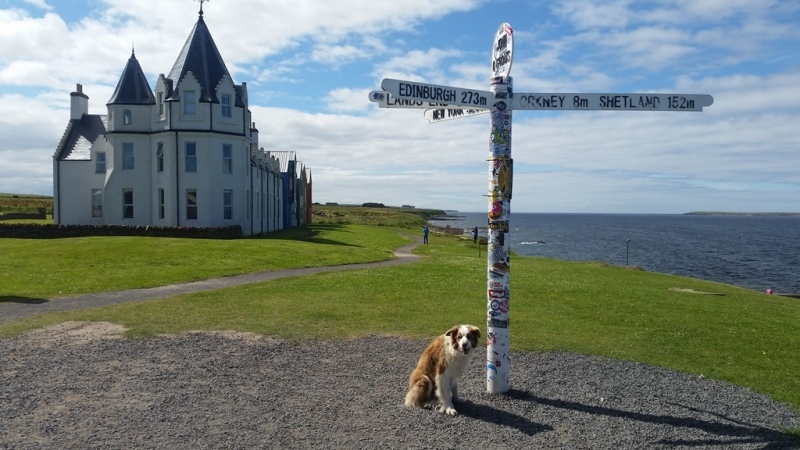
Profile Logo:
Once completed, you can add this logo to your profile:
Virtual Reward - 2017/2018
This Virtual Cache is part of a limited release of Virtuals created between August 24, 2017 and August 24, 2018. Only 4,000 cache owners were given the opportunity to hide a Virtual Cache. Learn more about Virtual Rewards on the Geocaching Blog.