The trail you want to take will be on the left side of the
creek. There is another trail across the creek that is wider but it
will NOT take you down to the falls. The terrain
will start out like any other but will get very narrow with steep
drop offs creekside so be very careful and watch your
footing. An alternate path would be to bring some old
shoes or water shoes and just walk the creek. It will bring you to
the top of the falls. Once there you can meet back up with the
trail on your left and follow it to the bottom. The water in the
creek when we were here was only about calf deep. It potentially
could be deeper after a lot of rain so use your best judgement.
This area is part of the Appalachian Valley of Virginia which is
part of the Great Appalachian Valley and is one of the major
landform features of eastern North America. It is a gigantic trough
— a chain of valley lowlands — and the central feature of the
Appalachian Mountain system. The trough stretches about 700 miles
from Canada to Alabama and has been an important north-south route
of travel since prehistoric times. These mountains are
characterized by long, even ridges, with long, continuous valleys
in between. From a great enough altitude, they look almost like
corduroy, except that the widths of the valleys are somewhat
variable and ridges sometimes meet in a vee. These curious
formations are the remnants of an ancient fold-and-thrust belt,
west of the mountain core that formed in the Alleghenian orogeny
(Stanley, 421-2). Here, strata have been folded westward, and
forced over massive thrust faults; there is little metamorphism,
and no igneous intrusion.(Stanley, 421-2) The ridges represent the
edges of the erosion-resistant strata, and the valleys portray the
absence of the more erodible strata. Smaller streams have developed
their valleys following the lines of the more easily eroded strata.
The streams can develop waterfalls along the way by eroding the
softer rock quicker such as in this case.
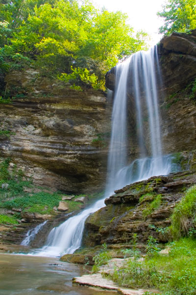
According to the USGS topo map, it calls the creek "Abrams
Creek" and it is between Leonard Hollow and Broad Hollow. It is a
branch off the North Fork of the Holston River near Mendota, VA.
The road is Abrams Falls Rd or Route 634. There is a place for
parking at the end of the road and then about a 1/4 mi hike.
A waterfall is usually a geological formation
resulting from water, often in the form of a stream, flowing over
an erosion-resistant rock formation that forms a sudden break in
elevation or nickpoint. Some waterfalls form in mountain
environments where the erosive water force is high and stream
courses may be subject to sudden and catastrophic change. In such
cases, the waterfall may not be the end product of many years of
water action over a region, but rather the result of relatively
sudden geological processes such as landslides, faults or volcanic
action.
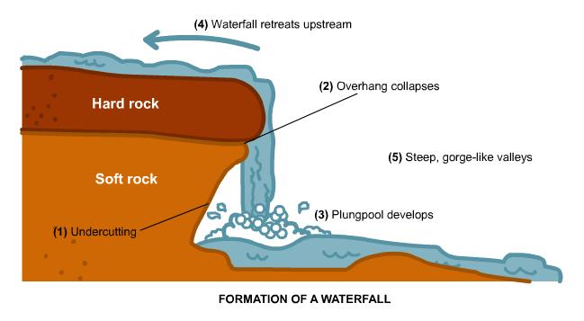
How Waterfalls are
Formed
Typically a stream or river flows
over a large step in the rocks which may have been formed by a
fault line. Over a period of years, the edges of this shelf will
gradually break away and the stream will retreat upstream, creating
a gorge of recession. Often the rock just below the more resistant
shelf will be a softer type, meaning some undercutting will occur
due to the splashback of the falling water. A shallow cave-like
formation known as a rock shelter or plunge pool under and behind
the waterfall will form. Eventually the outcropping of rock will
collapse under pressure to add blocks of rock to the base of the
waterfall. These blocks of rock are then broken down into smaller
boulder as they collide with each other and they also will continue
to erode at the base of the waterfall by abrasion, creating a
deeper plunge pool. Streams will become wider and more shallow just
above waterfall due to the flowing of the water over the rock shelf
and there is usually a deep pool just below the waterfall because
of the kinetic energy of the water hitting the bottom.
The rock canyon surrounding this waterfall is a direct
result of the above information. Over several thousands of years,
Mother Nature has used Abrams Creek to carve out the the Falls that
exist today.
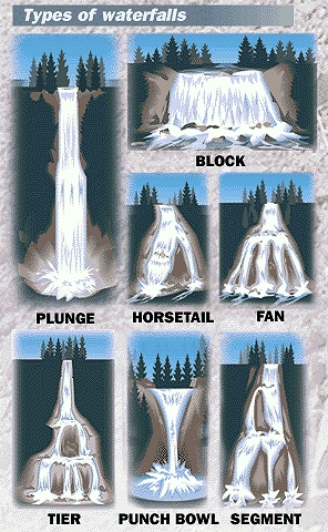
Types of Waterfalls
- Block: Water descends from a relatively wide
stream or river.
- Cascade: Water descends a series of rock
steps.
- Cataract: A large waterfall.
- Fan: Water spreads horizontally as it descends
while remaining in contact with bedrock.
- Horsetail: Descending water maintains some
contact with bedrock.
- Plunge: Water descends vertically, losing
contact with the bedrock surface.
- Punchbowl: Water descends in a constricted
form, then spreads out in a wider pool.
- Segmented: Distinctly separate flows of water
form as it descends.
- Tiered: Water drops in a series of distinct
steps or falls.
- Multi-step: A series of waterfalls one after
another of roughly the same size each with its own sunken plunge
pool.
This magnificant waterfall and pool took
millions of years to form so enjoy and take care of it.
In order to recieve credit for this Earthcache you must
do the following....
1. Post a picture of you/your group holding your gps in front of
the waterfall with your log.
2. Email the owner with answers to the following questions.
a)Describe what type of waterfall Abram Falls is--this may include
more than one of the classifications.
b) Estimate the height of Abrams Falls. (needs to be within 10
feet)