This is collectible.
Diese große - immerhin 85 mm - und großartige Coin zieht nun auch in meine Sammlung ein - ich belasse es hier bei der Erklärung der offiziellen Homepage:
This big - real 85 mm - and great coin now is moving into my collection as well - as for the explanation of it I'm copying the official description here:
Als Planisphäre wird ursprünglich die Zentralprojektion der Himmelssphäre auf eine Ebene bezeichnet.
Die Projektion erfolgt in der Regel aus einem der beiden Himmelspole, wobei die Gegend um das Projektionszentrum prinzipiell nicht abbildbar ist. Bei Projektion aus dem Südpol wird der Nordhimmel bis zum südlichen Wendekreis , aus dem Nordpol der Südhimmel bis zum nördlichen Wendekreis erfasst.
Die Konstruktion von Planisphären wird z. B. von Ptolemäus beschrieben. Obwohl keine antiken Planisphären erhalten sind, handelt es sich bei Exemplaren aus dem 8. bis 10. Jahrhundert vermutlich um direkte Kopien antiker Vorlagen.
Drehbare Sternenkarte (drehbares Stern-Diagramm):
Der durch das Fenster sichtbare Teil einer drehbaren Sternkarte ist der von einer bestimmten geographischen Breite aus im Verlauf des Jahres beobachtbare Sternenhimmel. Der Fensterrand ist das Bild des Horizonts.
Drehbare Stern-Diagramme (Planisphären) sind ideal für das Erlernen der Bestimmung der sichtbaren Sterne sowie verhalfen bei der Verwendung von Quadranten und Nocturnals zu einer schnelleren (und oft auch genaueren) Messung.
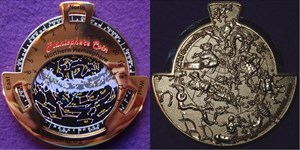
Diese Geocoin ist eine funktionierende Planisphäre (drehbare Sternkarte), mit der man auf der nördlichen Erdhalbkugel im Lauf des Jahres die Positionen der Sterne am Himmel verfolgen kann (wenn auch natürlich nicht mit der Genauigkeit eines auf eine bestimmte Position eingestellten Astronomischen Gerätes).
Es sind sowohl Versionen der nördlichen als auch der südlichen Hemisphäre verfügbar. Wir empfehlen Ihnen, beide Versionen zu erwerben, wenn Sie zwischen 30 ° nördlicher und 30 ° südlicher Breite leben.
Anleitung zur Benutzung dieser Geocoin (englisch) unter www.compassrosegeocoin.com/planisphere.php
This is a functional planisphere coin which you can actually use to locate constellations.
Planispheres are maps of the celestial stars as seen from earth. They are the replacement for the planispheric astrolabe. Planispheres drastically reduced the complexities of the planispheric astrolabes and they mapped the heavens in an easier to follow chart. The first star chart to be called a planisphere was created in 1624. Planispheres are great for learning the constellations and knowing the exact position of the stars at a particular time to get more accurate readings when used with other navigational tools such as the quadrant, nocturnal, astrolabe, back staff, and sextant.
One disadvantage of translating stars from an actual spherical view our sky to a flat disk is the effect of distortion on the real size of the constellations towards the edge of the disk. It causes the images towards the edge of the disk to become stretched out. However, with some practice you will become a pro with this device in no time and be able to compensate for this distortion.
Normally, planispheres consist of several disks which map the stars as viewed from different latitudes and for different seasons. The planisphere geocoins we have made do not have interchangeable disks; however, they still give you a good idea of where the stars are at any time of day, and provide you with a pocket sized tool to help learn the constellations. Its 3.25" diameter size makes it portable, and being made out of metal makes it very durable.
Both Northern Hemisphere and Southern Hemisphere versions are available. We recommend you get both versions if you live between the 30 degree north and 30 degree south latitudes.
Instructions for using this Geocoin (English) at www.compassrosegeocoin.com/planisphere.php